Midday Nowcast: Some Clouds and Light Rain
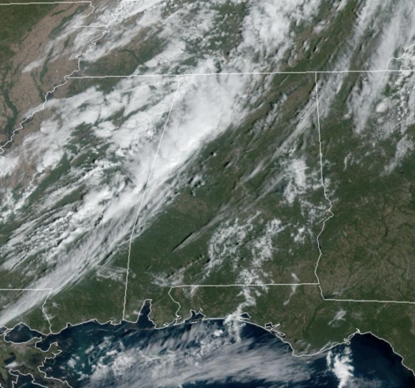
FRONT ON THE WAY: Today is a mainly dry day, but clouds are increasing, and rain chances return later today and tonight ahead of a cold front swinging through the state. Moisture will be limited, meaning rain amounts will be light; generally under a quarter of an inch. In fact, many locations will remain dry. Highs today are in those sensational 70s. The rain chances end by early tomorrow morning and the sky will be clearing by the afternoon across the state. Highs tomorrow will remain in the low to mid 70s.
FRIDAY NIGHT LIGHTS: The sky will be clear with temperatures falling from near 65° at kickoff, into the upper 50s by the final whistle. A fantastic Friday night for football across Alabama.
FANTASTIC FALL WEEKEND: Another surge of dry air rolls into the state Friday night, and the weekend will feature sunny pleasant days and clear cool nights. Highs will be in the upper 70s Saturday, followed by low to mid 70s Sunday. Nights will remain cool with 40s most common across the North/Central Alabama.
FOOTBALL WEATHER: Saturday, UAB will host Memphis at Protective Stadium in downtown Birmingham (11a CT kickoff)…the sky will be sunny with temperatures rising from near 72° at kickoff, to around 77° by the fourth quarter.
Alabama hosts Tennessee at Bryant-Denny Stadium in Tuscaloosa (2:30p CT kickoff). It will be a fine fall afternoon with temperatures in the mid to upper 70s.
And, Auburn will host Ole Miss Saturday evening (6:00p CT kickoff) at Jordan-Hare Stadium. Expect a clear sky with temperatures falling from near 70° at kickoff, into the low 60s by the final whistle.
NEXT WEEK: A ridge will build across the Deep South, meaning dry weather is likely through the week with highs mostly in the 70s, and lows in the 40s and 50s. Our next rainmaker looks to arrive towards the end of next week and into the weekend, but that is still ten days away and timing of the system will change.
IN THE TROPICS: We have Tropical Storm Tammy. Tammy is moving toward the west-northwest near 15mph. A turn toward the northwest is expected Friday night or Saturday. On the forecast track, the center of Tammy will move near or over the Leeward Islands Friday and Saturday. Data from an a NOAA Hurricane Hunter aircraft indicate that the maximum sustained winds are near 60 mph with higher gusts. Gradual strengthening is forecast during the next few days and Tammy could be near hurricane intensity by early Saturday. Tropical-storm-force winds extend outward up to 140 miles from the center. The estimated minimum central pressure is 1004 mb (29.65 inches).
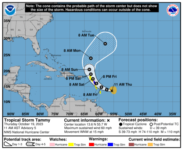
The rest of the basin is quiet. Hurricane season ends November 30th and the remaining names on list this year are Vince and Whitney.
BEACH FORECAST CENTER: Get the latest weather and rip current forecasts for the beaches from Fort Morgan to Panama City on our Beach Forecast Center page. There, you can select the forecast of the region that you are interested in visiting.
WORLD TEMPERATURE EXTREMES: Over the last 24 hours, the highest observation outside the U.S. was 109.4F at Hermosillo, Mexico. The lowest observation was -87.7F Vostok, Antarctica.
CONTIGUOUS TEMPERATURE EXTREMES: Over the last 24 hours, the highest observation was 105F at Ogilby, CA. The lowest observation was 16F at Peter Sinks, UT.
Category: Alabama's Weather, ALL POSTS
About the Author (Author Profile)
Macon, Georgia Television Chief Meteorologist, Birmingham native, and long time Contributor on AlabamaWX. Stormchaser. I did not choose Weather, it chose Me. College Football Fanatic. @Ryan_StinnetSubscribe
If you enjoyed this article, subscribe to receive more just like it.


