Midday Nowcast: Fine Friday and Warm Weekend Weather
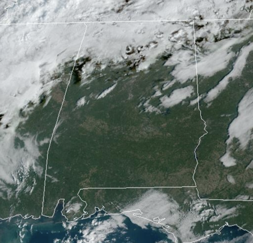
An upper ridge overhead, and surface high off the Carolina Coast, remain in control of our weather today and through the weekend. Expect partly to mainly sunny, warm days and fair nights. Temperatures will be in the upper 70s to mid 80s through Sunday, while nights will range from the mid 50s to mid 60s. It will remain dry with no chance of rain. Absolutely great weather for all the various fall festivals and events across Alabama this weekend.
FRIDAY NIGHT LIGHTS: The sky will be clear for the high school games across Alabama tonight with temperatures falling from the mid 70s at kickoff into the upper 60s by the quarter.
FOOTBALL FORECAST: For tomorrow’s Magic City Classic in Birmingham (Alabama State vs Alabama A&M, 2:30p CT kickoff at Legion Field)… the sky will be partly to mostly sunny with temperatures in the low to mid 80s. It will be a warm October afternoon.
Auburn hosts Mississippi State (2:30p CT kickoff) at Jordan Hare Stadium… dry and warm weather is the story with temperatures in the 81-84 degree for most of the game. The sky will be mostly sunny.
NEXT WEEK: A very sharp cold front will move through Alabama Monday. A few sprinkles are possible, but don’t count on the rain. Behind the front, the coldest air so far this season will roll into the state late Monday and into Tuesday. Much of next week will feature the sunny, cool days, with clear and cold nights. Highs will drop into the 50s and 60s, while lows will hold fall into the 30s and 40s. Many locations across North Alabama, will likely see the first freeze of the season. Still no signs of meaningful or beneficial rain for Alabama the next 7-10 days.
IN THE TROPICS: Tammy will likely come back from the dead. A strong extratropical cyclone (formerly Tammy) associated with an occluded front is located a few hundred miles east of Bermuda. This low is forecast to become separated from the front soon, and conditions appear favorable for the system to redevelop into a tropical storm later today or Saturday. Regardless of tropical redevelopment, the system is likely to bring gusty winds to Bermuda during the next day or so, and a gale warning is in effect for the island. Interests on Bermuda should monitor the progress of this system. Formation chance through 48 hours…high…70 percent.
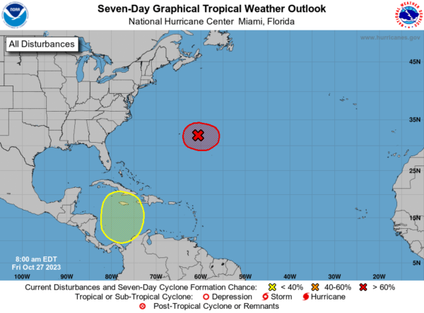
Also, in the Western Caribbean Sea, a broad area of low pressure is forecast to develop over the southwestern Caribbean Sea during the next few days. Environmental conditions could support some slow development of this system early next week while it moves generally northward. Formation chance through 7 days…low…30 percent. We will need to keep an eye on this feature next week as the long range models do pull it north towards the Gulf.
Hurricane season ends November 30th and the remaining names on list this year are Vince and Whitney.
BEACH FORECAST CENTER: Get the latest weather and rip current forecasts for the beaches from Fort Morgan to Panama City on our Beach Forecast Center page. There, you can select the forecast of the region that you are interested in visiting.
WORLD TEMPERATURE EXTREMES: Over the last 24 hours, the highest observation outside the U.S. was 125.8F at Sharurah, Saudi Arabia. The lowest observation was -77.4F Dome A, Antarctica.
CONTIGUOUS TEMPERATURE EXTREMES: Over the last 24 hours, the highest observation was 95F at Rio Grande Village, TX. The lowest observation was -17F at Peter Sinks, UT.
Category: Alabama's Weather, ALL POSTS
About the Author (Author Profile)
Macon, Georgia Television Chief Meteorologist, Birmingham native, and long time Contributor on AlabamaWX. Stormchaser. I did not choose Weather, it chose Me. College Football Fanatic. @Ryan_StinnetSubscribe
If you enjoyed this article, subscribe to receive more just like it.


