Afternoon Briefing: The Patient and the Forecast Are Holding Up Well
Our fearless leader scared us all badly last night with severe abdominal pains that sent him to the hospital for a little late night surgery. But he was texting orders by 4:30 a.m. and feeling like a new man he said. We are all thankful for the doctors and nurses who turned a bad situation into good. I know he appreciates all your thoughts and prayers! No video today as we are traveling and he hasn’t gotten his green screen installed at the hospital. Yet.
THE WEATHER ROLLS ON: The weather for the rest of this week is a blend of mild temperatures, some rain (just not enough), and gradually clearing skies in time for a decent weekend.
CLOUDS HANG TOUGH: Skies have been mostly cloudy across muckier h of North and Central Alabama on your Tuesday. There has been a tad more sunshine over the Tennessee Valley today. Temperatures are generally in the upper 60s to near 70F. Lows tonight will be in the upper 40s generally, with a few lows 50s.
ON THE WEATHER MAPS: Our surface low is south of the Louisiana coast. It is about 100 miles south of where we thought it might be, which has kept the rainfall closer to the coast. That main shield of rain has spread as far north as Greenville and Troy so far today. The low is expected to pirouette around its parent upper low and move toward the Alabama/NW Florida coast. As it does rain will increase over southern Mississippi and Alabama and it will spread into our state late tonight and in to Wednesday.
HUMP DAY: As we approach the midweek hump, rain will be likely on Wednesday, and temperatures will be cooler, with highs in the middle and upper 50s.
HOW ABOUT THURSDAY?: A few scattered showers will be left over on Thursday, even as the first low weakens, and a second low forms off the Southeast Coast of Florida. Look for highs in the middle and upper 60s.
FRIDAY: Lows will start out in the middle 50s Friday, with high temperatures warming into the upper 70s ahead of a cold front. The front won’t have a chance to create much in the way of showers, since it is short of moisture. Expect a mix of broken and overcast skies.
WEEKEND OUTLOOK: The weekend brings a shift towards cooler, clearer weather. Saturday offers a cooler high of 64°F after a morning low of 51°F, with a 30% chance of rain and partly cloudy skies. Sunday features more in the way of sunshine. featuring no rain, and a high of 65°F, under mostly clear to partly cloudy skies.
MOVING INTO VOODOO: The week two forecast period, Monday will feature highs in the 60s with some chance of rain as another disturbance moves towards us in a zonal flow. ger system will roll through on Friday with rain and storms, moving out before the weekend. Either way, Thanksgiving looks dry now now.
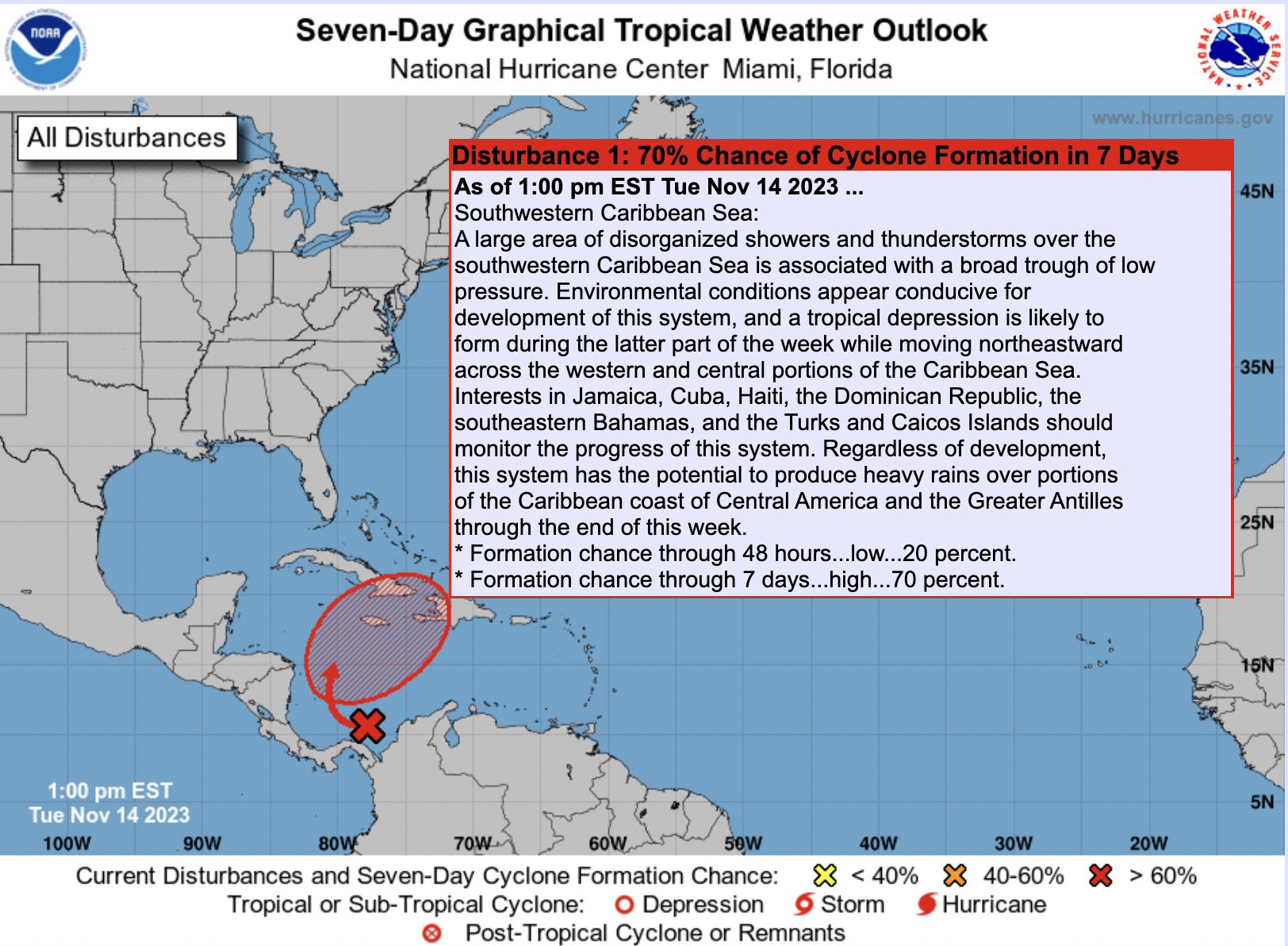
IN THE TROPICS: Low pressure is expected to form in the southwestern Caribbean in the next 24 hours and could become a tropical depression by midweek. It is expected to begin moving northeast by Thursday and could become Tropical Storm Vince by late Thursday or Friday as it moves toward Hispaniola. It will cross that island and emerge into the Atlantic north of the Dominican Republic by the weekend. There is some chance it could still become a hurricane by early in week two, but should be no threat to any land areas. There is not much certainty in this forecast though, as the latest GFS is not nearly as bullish on the idea.
BEACH FORECAST CENTER: The weather is going to go downhill fast along the beautiful beaches of Alabama and Northwest Florida as the low pressure system in the Gulf intensifies and swings their way. Winds will be increasing to 20-25 with gusts to 35-40 mph and seas will rise to 5-7 feet. The rip current risk will be high for the foreseeable future. Widespread heavy rainfall will affect the coast through Wednesday, diminishing by Thursday. The weekend looks nice. Get the latest weather and rip current forecasts for the beaches from Fort Morgan to Panama City on our Beach Forecast Center page. There, you can select the forecast of the region that you are interested in visiting.
WEATHERBRAINS: Show 930 was a lot of fun last night with Ashley Gann, a local meteorologist who has traded in her green screen for the greener pastures of higher education as the Public Information Officer at Auburn University. That show is live on all the podcast channels today.
ON THIS DATE IN 2008: An African EF3 or EF4 tornado leveled brick homes in an urban area of Molweni. 8 people died along its 10 mile path. Mud huts were completely scored away.
Category: Alabama's Weather, ALL POSTS
About the Author (Author Profile)
Bill Murray is the President of The Weather Factory. He is the site's official weather historian and a weekend forecaster. He also anchors the site's severe weather coverage. Bill Murray is the proud holder of National Weather Association Digital Seal #0001 @wxhistorianSubscribe
If you enjoyed this article, subscribe to receive more just like it.


