Midday Nowcast: A Cloudy and Wet Wednesday
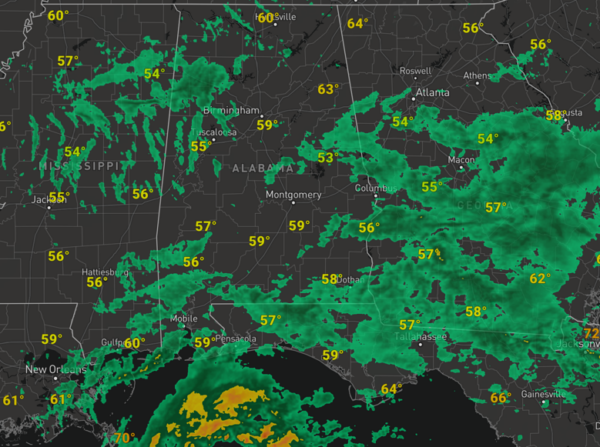
An area of low pressure in the Northern Gulf of Mexico continues to spread clouds and moisture north today. Widespread areas of rain are ongoing across much of Alabama and the Southeast today and it remains a rather wet and dreary November day for the state. With the clouds and rain, temperatures are holding in the 50s for much of Alabama today. Pockets of rain will continues tonight with lows in the low 50s. The more widespread rain and heavy downpours will remain across southern portions of the state.
TOMORROW/FRIDAY: Some lingering rain will continue across Alabama tomorrow, again, higher coverage across southern sections of the state. On Friday, a cold front will keep the chance of showers in the forecast statewide Friday, so keep the rain gear close. Highs tomorrow and Friday will be in the 60s for most locations and the sky will remain mainly cloudy both days.
WONDERFUL WEEKEND WEATHER: The weekend looks great with dry and mainly sunny days, and highs generally in the low to mid 60s. Nights will be clear and chilly, with lows in the upper 30s and lower 40s.
INTO NEXT WEEK: We are starting to get a better idea on the forecast for next week as models begin to come into agreement, but there remains challenges with timing. Good news for now, both the European and GFS American model show Thanksgiving and Iron Bowl Saturday will be dry for Alabama. As far as the rest of the week, rain and storms should begin to return as early as Monday for the state, and we will continue to leave of rain and storms in the forecast Tuesday and Wednesday for the state as the model struggle with the track and overall intensity of the low. Again timing and overall impacts remain uncertain; we could have some strong storms, or we could just be dealing with plain old rain, so stay tuned…
IN THE TROPICS: Two features the NHC is monitoring: One is in Southwestern Caribbean Sea is a broad area of disorganized showers and thunderstorms over the southwestern Caribbean Sea is associated with a trough of low pressure. Environmental conditions appear marginally conducive for development of this system, and a tropical depression could still form by the weekend while the system begins moving northeastward across the western and central portions of the Caribbean Sea. Interests in Jamaica, Cuba, Haiti, the Dominican Republic, the southeastern Bahamas, and the Turks and Caicos Islands should monitor the progress of this system. Regardless of development, this system has the potential to produce heavy rains over portions of the Caribbean coast of Central America and the Greater Antilles through the weekend. Formation chance through 7 days…medium…50 percent.
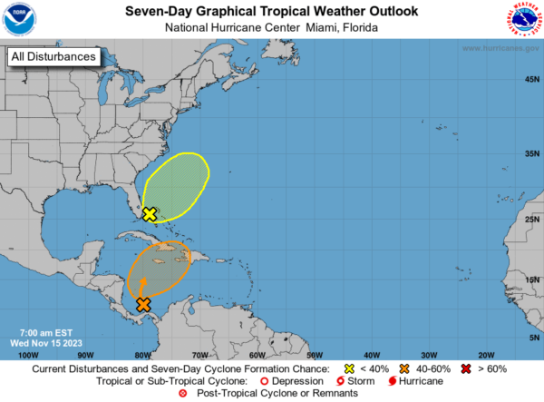
Also, off the Southeast Coast of United States, non-tropical area of low pressure is expected to develop near southern Florida along a surface trough over the next day or so. This system is then forecast to move northeastward near the Bahamas and offshore of the east coast of the U.S. late this week and over the weekend. Although development into a tropical cyclone appears unlikely, this system is expected to produce gusty winds and heavy rains across portions of southern Florida, the Florida Keys, and the Bahamas during the next couple of days. For more information on this system, including gale warnings, see High Seas Forecasts issued by the National Weather Service. Formation chance through 7 days…low…10 percent.
Hurricane season ends November 30th and the remaining names on list this year are Vince and Whitney.
BEACH FORECAST CENTER: Get the latest weather and rip current forecasts for the beaches from Fort Morgan to Panama City on our Beach Forecast Center page. There, you can select the forecast of the region that you are interested in visiting.
WORLD TEMPERATURE EXTREMES: Over the last 24 hours, the highest observation outside the U.S. was 111.0F at Vioolsdrif, South Africa. The lowest observation was -68.8F Dome A, Antarctica.
CONTIGUOUS TEMPERATURE EXTREMES: Over the last 24 hours, the highest observation was 89F at Phoenix, AZ. The lowest observation was 8F at Alamosa, CO.
Category: Alabama's Weather, ALL POSTS
About the Author (Author Profile)
Macon, Georgia Television Chief Meteorologist, Birmingham native, and long time Contributor on AlabamaWX. Stormchaser. I did not choose Weather, it chose Me. College Football Fanatic. @Ryan_StinnetSubscribe
If you enjoyed this article, subscribe to receive more just like it.


