Midday Nowcast: Some Sun and Some Clouds
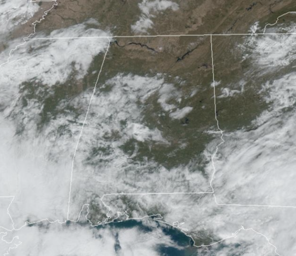
Some lingering rain will continue across portions of Alabama at times today, again, higher coverage across southern sections of the state. Tomorrow, a cold front will keep the chance of showers statewide, so keep the rain gear close just in case. Highs today and tomorrow will be in the 60s and 70s for most locations and the sky will feature sun at times and clouds at times.
FRIDAY NIGHT FOOTBALL: For those high school playoff games tomorrow night, most stadiums will be dry, but still a few lingering showers may be possible. It will remain mainly cloudy with temperatures falling through the 60s.
WONDERFUL WEEKEND WEATHER: The weekend looks great with dry and mainly sunny days, and highs generally in the low to mid 60s. Nights will be clear and chilly, with lows in the upper 30s and lower 40s.
FOOTBALL FORECAST: Alabama and the Chattanooga Mocs will tangle in Tuscaloosa at 11 a.m. The sky will be clearing and it will be perfect day of weather. Temperatures are going to be cool around 63°F at kickoff and will hold in the 60s the entire game.
Auburn vs New Mexico State, 3 pm Saturday it will be sunny with temperatures at kickoff 69°F, will have fallen to a brisk 59°F by the final whistle.
Temple at UAB, with a 2 PM kickoff at Protective Stadium in Birmingham. Temperatures at kickoff will be 62°F and fall back to a crisp 59°F by the final whistle.
INTO NEXT WEEK: Good news, both the European and GFS American model continue to show Thanksgiving, Black Friday, and Iron Bowl Saturday will be dry for Alabama, but it will be chilly with highs in the 50s and lows in the 30s. However, rain and storms will start the week, Monday and into Tuesday and we could have some strong storms mixed in with the rain. Stayed tuned, as the details of the forecast come better into focus in the coming days.
IN THE TROPICS: Two features the NHC is monitoring: In the West-Central Caribbean Sea, Showers and thunderstorms associated with a broad area of low pressure located over the west-central Caribbean Sea have become a little better organized since yesterday. Environmental conditions appear conducive for some additional development, and a tropical depression could form over the next day or two while the low moves northeastward toward Jamaica, Haiti, and eastern Cuba. An Air Force Reserve reconnaissance aircraft is scheduled to investigate the system this afternoon. Regardless of development, this system is expected to produce heavy rains that could result in flash flooding and mudslides over portions of the Greater Antilles through this weekend. Interests in Jamaica, Cuba, Haiti, the Dominican Republic, the southeastern Bahamas, and the Turks and Caicos Islands should continue to monitor the progress of this system. Formation chance through 7 days…medium…60 percent.
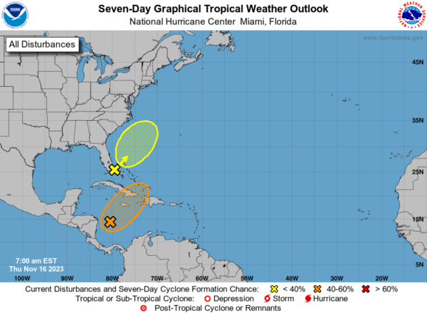
Second, offshore Southeast Coast of United States, a non-tropical area of low pressure between southern Florida and the northwestern Bahamas is associated with a frontal boundary. Development of this system into a tropical cyclone appears unlikely. However, gusty winds and heavy rains are still possible across portions of the east coast of Florida and the Bahamas during the next day or so while the low moves quickly northeastward over the southwestern Atlantic. For more information on this system, including storm warnings, see High Seas Forecasts issued by the National Weather Service. Formation chance through 7 days…low…10 percent.
Hurricane season ends November 30th and the remaining names on list this year are Vince and Whitney.
BEACH FORECAST CENTER: Get the latest weather and rip current forecasts for the beaches from Fort Morgan to Panama City on our Beach Forecast Center page. There, you can select the forecast of the region that you are interested in visiting.
WORLD TEMPERATURE EXTREMES: Over the last 24 hours, the highest observation outside the U.S. was 114.8F at Augrabies Falls, South Africa. The lowest observation was -68.4F Dome A, Antarctica.
CONTIGUOUS TEMPERATURE EXTREMES: Over the last 24 hours, the highest observation was 88F at Phoenix, AZ. The lowest observation was 17F at Davis, WV.
Category: Alabama's Weather, ALL POSTS
About the Author (Author Profile)
Macon, Georgia Television Chief Meteorologist, Birmingham native, and long time Contributor on AlabamaWX. Stormchaser. I did not choose Weather, it chose Me. College Football Fanatic. @Ryan_StinnetSubscribe
If you enjoyed this article, subscribe to receive more just like it.


