

Midday Nowcast: Showers and Storms Shifting to the East
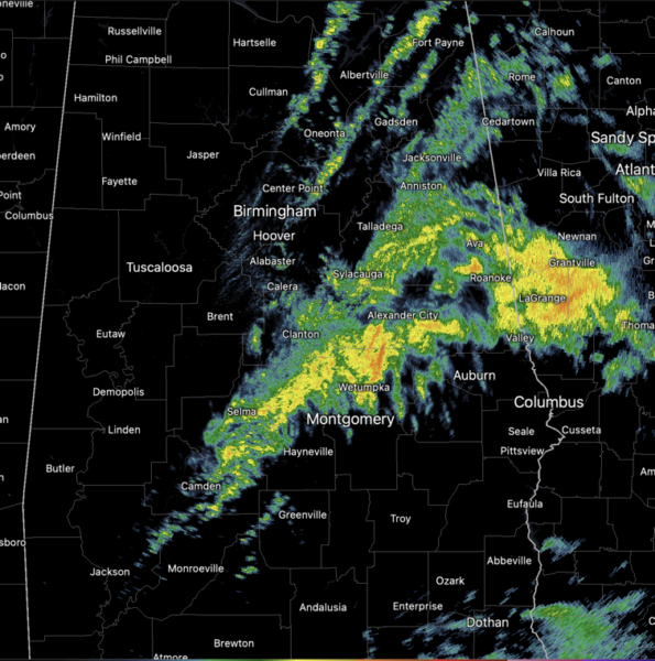
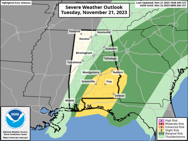
Most of the rain and storms are down across southeastern portions of the state this afternoon, and all the storms should be out of the state by late this evening. However, through the afternoon hours, the SPC maintains the risk of severe weather for eastern and southeastern portions of the state.
For North/Central Alabama, the rain will wind down through the afternoon hours, and we may see some peeks of sunshine at times. Temperatures this afternoon are mainly in the 60s. Tonight will be a colder night with lows falling back into the 40s, and we can’t completely rule out a few lingering sprinkles.
TOMORROW/THANKSGIVING: Tomorrow, an upper low will swing through the state, causing it to be a mostly cloudy and colder day with highs in the 50s. A few sprinkles are possible under the upper low over the northern third of the state. The sky should clear late in the day as drier air finally filters into the state. Thanksgiving Day will be cool and dry with a mostly sunny sky. We start the day in the upper 30s and low 40s, by the afternoon highs will be in the 50s for most of the state. Overall, a pretty decent Thanksgiving Day across Alabama.
FRIDAY AND THE WEEKEND: A weak surface low will move through the northern Gulf of Mexico, spreading some light rain northward into the state, but most of the rain will end early Friday. The greatest coverage of rain will be across southern sections of the state. By Friday afternoon and through the rest of the weekend, we are forecasting cool and dry weather with highs generally in the 50s, and lows in the 30s and 40s.
IRON BOWL FORECAST: The weather looks delightful for Saturday’s Iron Bowl (Alabama at Auburn; 2:30p CT kickoff). The sky will be partly sunny with temperatures falling from near 62 degrees at kickoff into the 50s by the fourth quarter. No risk of rain.
NEXT WEEK: For now, the week starts off dry, but by mid-week another low tracking through the northern Gulf which could spread rain back into Alabama. Highs will be in the 50s and 60s, and lows will be in the 40s. With this being an El Niño winter, get use to lows moving across the northern Gulf of Mexico as the storm track tends to be farther south during El Niño. This will be a common occurrence the next several months.
IN THE TROPICS: Still two areas the NHC is monitoring, for possible development. Hurricane season officially ends at the end of the month.
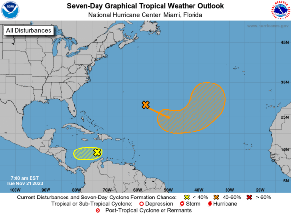
Disorganized showers and thunderstorms over the central Caribbean Sea are associated with a small area of low pressure. Nearby dry air is forecast to prevent additional significant development of the system as it begins to drift slowly westward during the next couple of days. Formation chance through 7 days…low…10 percent.
Also, in the Central Subtropical Atlantic, an area of low pressure is expected to develop along a frontal boundary over the central subtropical Atlantic later today. This non-tropical low is forecast to move southeastward across the central subtropical Atlantic over warmer sea surface temperatures during the next few days, and environmental conditions appear conducive for this system to gradually acquire tropical characteristics. A subtropical or tropical storm could form by the latter part of this week, as the system continues moving eastward followed by a turn northeastward by the weekend. Formation chance through 7 days…medium…60 percent.
BEACH FORECAST CENTER: Get the latest weather and rip current forecasts for the beaches from Fort Morgan to Panama City on our Beach Forecast Center page. There, you can select the forecast of the region that you are interested in visiting.
WORLD TEMPERATURE EXTREMES: Over the last 24 hours, the highest observation outside the U.S. was 111.9F at Marble Bar, Australia. The lowest observation was -65.2F Dome A, Antarctica.
CONTIGUOUS TEMPERATURE EXTREMES: Over the last 24 hours, the highest observation was 88F at Sunniland, FL. The lowest observation was -12F at Peter Sinks, UT.
Category: Alabama's Weather, ALL POSTS
About the Author (Author Profile)
Macon, Georgia Television Chief Meteorologist, Birmingham native, and long time Contributor on AlabamaWX. Stormchaser. I did not choose Weather, it chose Me. College Football Fanatic. @Ryan_StinnetSubscribe
If you enjoyed this article, subscribe to receive more just like it.


