Midday Nowcast: Increasing Clouds; Rain Arrives Tonight
SO LONG NOVEMBER: It will remain dry today with highs in the low 60s, but clouds are increasing and rain will return to Alabama later tonight. Enjoy what sunshine you see today, because it will likely be next week before we see it again with the active weather pattern through the weekend.
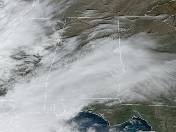
RAIN RETURNS: Multiple rounds of rain and storms will bring very beneficial rain to Alabama tomorrow and through the weekend. The rain will move into Alabama tonight, and for tomorrow, the SPC maintains a low end “marginal risk” (level 1/5) of severe thunderstorms for the southern 2/3 of Alabama (Calera and to the south). There could be sufficient instability for a few storms with gusty winds during tomorrow.
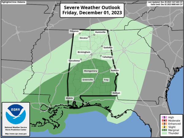
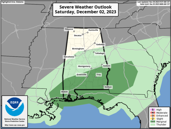
More rain and storms will occur Saturday and Sunday across Alabama. Again, the weekend won’t be a complete washout, but when it is raining, the rainfall will be heavy at times. A few thunderstorms could be involved, and there is “marginal risk” (level 1/5) for the southern counties (south of Montgomery). The main threat from the heavier storms tomorrow and Saturday over South Alabama will come from gusty winds; the tornado threat is very low.
Rain will end across the state through the day Sunday, but clouds will linger. Highs the next three days will be in the low to mid 60s for much of the state.
POTENTIAL RAINFALL: South Alabama has the potential for 2-4 inches of rain through Sunday night, with 1-2 inches over the northern half of the state. Very beneficial considering the ongoing drought. It won’t completely wipe out the drought conditions, but it will certainly help.
FOOTBALL WEATHER: For the high school playoff games tomorrow night, the sky will be mostly cloudy with temperatures in the low to mid 60s. We should be in the middle of a break in the rain for most places, but a few scattered showers or storms can’t be ruled out, mainly over the southern half of Alabama.
For fans headed to the SEC Championship game in Atlanta Saturday (Alabama vs Georgia; 3pm CT kickoff at Mercedes Benz Stadium), rain is likely with temperatures in the mid 60s during the afternoon hours. Thankfully the game will be played “indoors” under the roof.
NEXT WEEK: Next week still looks relatively quiet and dry. We will stick with highs in the 50s and 60s, and lows mainly in the 30s and 40s. Not too far from seasonal values for early December.
IN THE TROPICS: All is quiet across the Atlantic basin and hurricane season officially ends today.
BEACH FORECAST CENTER: Get the latest weather and rip current forecasts for the beaches from Fort Morgan to Panama City on our Beach Forecast Center page. There, you can select the forecast of the region that you are interested in visiting.
WORLD TEMPERATURE EXTREMES: Over the last 24 hours, the highest observation outside the U.S. was 112.3F at Vredendal, South Africa. The lowest observation was -61.2F Dome A, Antarctica.
CONTIGUOUS TEMPERATURE EXTREMES: Over the last 24 hours, the highest observation was 77F at Miami, FL and Rio Grande Village, TX. The lowest observation was -18F at Peter Sinks, UT.
Category: Alabama's Weather, ALL POSTS
About the Author (Author Profile)
Macon, Georgia Television Chief Meteorologist, Birmingham native, and long time Contributor on AlabamaWX. Stormchaser. I did not choose Weather, it chose Me. College Football Fanatic. @Ryan_StinnetSubscribe
If you enjoyed this article, subscribe to receive more just like it.


