Midday Nowcast: Quiet Weather Pattern with Sunny Days
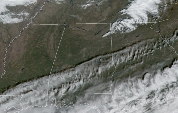
Alabama’s weather will be quiet and dry through Friday; expect mostly sunny days and fair nights. Highs today are ranging from the upper 50s to the north, to upper 60s near the coast. This afternoon, a clipper system will push a dry cold front through the state, and reinforce the dry air in place.
ACROSS THE USA: Rounds of moisture will continue to bring periods of heavy rain, mountain snow, and high winds through this week across the Northwest U.S. into the central and northern Rockies. Urban, small stream, and moderate to isolated major river flooding impacts are expected between Puget Sound and the Cascades through mid-week. Meanwhile, heavy snow across northern New England will subside by tonight.
REST OF WEEK: Colder air drops into the state Wednesday, and by early Thursday morning temperatures will be below freezing over the northern half of the state. Highs Wednesday and Thursday will be mostly in the 50s, then rising into the 60s Friday. Again, a quiet and calm week of weather for Alabama.
CHAMPIONSHIP FOOTBALL: The Alabama Super 7 high school football championships will be played Wednesday through Friday in Tuscaloosa at Bryant-Denny Stadium. The weather will be cool and dry for all the games; daytime temperatures will be in the 50s Wednesday and Thursday, and in the 60s Friday. For the evening games, temperatures will be mostly in the 40s. No risk of any rain.
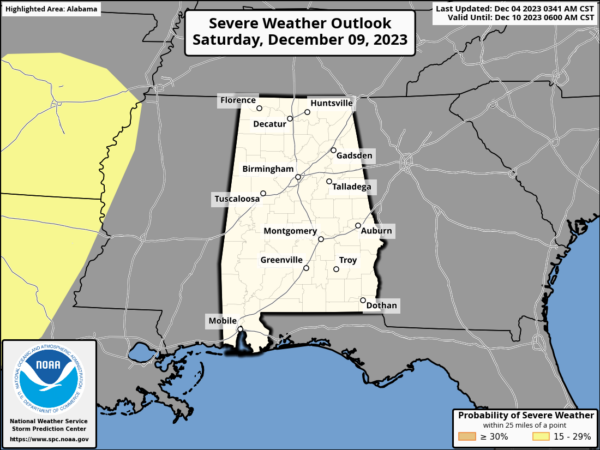
WEEKEND RAN AND STORMS: A dynamic weather system will bring rain and thunderstorms back to Alabama. For now it looks like the best chance of rain will come Saturday night into Sunday morning. The SPC has defined a risk of severe thunderstorms west of Alabama Saturday, but no formal risk has been defined here at this time. For now it looks like the storms will come through at a time when there is little to no surface based instability across the state, but we will watch model trends closely over the next few days.
More beneficial rain is expected over the weekend with amounts in the 1/2 to 1 inch range, with the heavier totals over the northern counties. Highs Saturday will be closer to 70°, but behind the front, highs Sunday would fall into the 50s with a cool north breeze. The cool and dry air mass looks to continue into at least the first half of next week.
BEACH FORECAST CENTER: Get the latest weather and rip current forecasts for the beaches from Fort Morgan to Panama City on our Beach Forecast Center page. There, you can select the forecast of the region that you are interested in visiting.
WORLD TEMPERATURE EXTREMES: Over the last 24 hours, the highest observation outside the U.S. was 114.6F at Warburton Airfield, Australia. The lowest observation was -72.4F Iema, Russia.
CONTIGUOUS TEMPERATURE EXTREMES: Over the last 24 hours, the highest observation was 90F at Boca Raton, FL. The lowest observation was 5F at Wabeno, WI.
Category: Alabama's Weather, ALL POSTS
About the Author (Author Profile)
Macon, Georgia Television Chief Meteorologist, Birmingham native, and long time Contributor on AlabamaWX. Stormchaser. I did not choose Weather, it chose Me. College Football Fanatic. @Ryan_StinnetSubscribe
If you enjoyed this article, subscribe to receive more just like it.


