Midday Nowcast: Sunshine in Full Supply for Most of Alabama
GOOD-LOOKING THURSDAY: Dry air has returned to Alabama today and afternoon temperatures are heading into the low to mid 50s. We do note that the Tennessee Valley of the state remains socked in with clouds, but the rest of the state is sunny. Tonight will be generally clear with lows ranging from the mid 20s to lower 30s.
USA BRIEF: A series of storms will continue to impact Alaska through the weekend. A storm tracking across the Southwest providing rain and snow, will spread into the central/southern Plains with accumulating snow expected. This system tracks along the Gulf coast Friday then into the mid-Atlantic region this weekend. Heavy rain across the South and Southeast, snow for portions of mid-Atlantic and Northeast.
RAIN RETURNS: The daytime hours tomorrow will be dry, but clouds will be increasing through the day as our next weather system approaches from the west. Rain should begin to enter west and southwest Alabama by the evening hours, and will spread through the state as we head into the overnight hours. This looks to be a very nice soaking rain with rainfall totals around one inch, with some isolated higher amounts. We may have a few rumbles of thunder, but there is no threat of severe weather for most of the state.
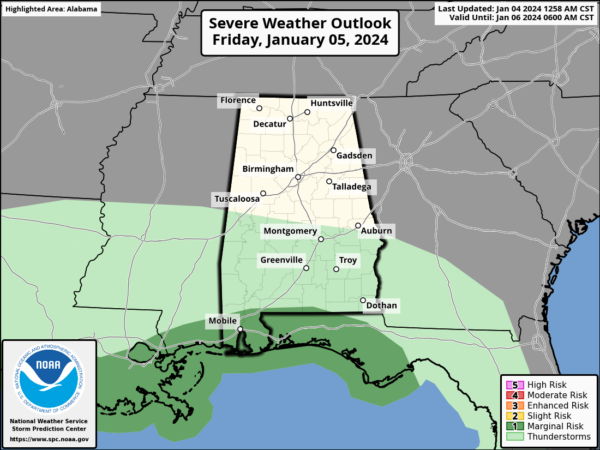
The low will remain to the south of us along the Gulf Coast, so some severe storms will be possible down that way. The SPC maintains a (level 1 of 5) “marginal risk” of severe thunderstorms for areas along the immediate Gulf Coast tomorrow night and early Saturday morning. Storms down that way could produce strong gusty winds, and a brief, isolated tornado can’t be ruled.
WEEKEND WEATHER: The rain ends during the early morning hours Saturday with clouds likely lingering most of the day. Late during the afternoon hours, the sky will begin to gradually clear. Sunday will be dry with a mostly sunny sky and highs will be in the 50s both days this weekend.
NEXT WEEK: Another dynamic system will bring rain and storms back to Alabama Monday night into Tuesday. This system has the potential to produce another 1-2 inches of rain, but could also bring some strong storms back to the state as the low will be to the north of us. For now, the SPC has the southern quarter of the state highlighted in a risk of severe storms on their “Day 5 Convective Outlook.”
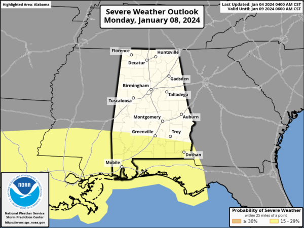
For South Alabama the main threat from stronger storms will come from strong winds, but again a brief tornado or two will be possible. At the moment it looks like most of the rain will come from about midnight Monday night through noon Tuesday. Gradient winds (not related to thunderstorms) will be strong, possibly gusting to 40 mph in spots.
We will continue to monitor trends with this system, as the severe weather threat could move farther north in future forecasts. For the rest of next week, it will be dry with highs in the 50s and lows in the 30s. The next rain maker looks to arrive over the weekend (January 13th-14th).
BEACH FORECAST CENTER: Get the latest weather and rip current forecasts for the beaches from Fort Morgan to Panama City on our Beach Forecast Center page. There, you can select the forecast of the region that you are interested in visiting.
WORLD TEMPERATURE EXTREMES: Over the last 24 hours, the highest observation outside the U.S. was 115.2F at Siteki, Eswatini. The lowest observation was -64.3F at Suhana, Russia.
CONTIGUOUS TEMPERATURE EXTREMES: Over the last 24 hours, the highest observation was 76F at Big Pine Key, FL. The lowest observation was -10F at Forest Center, MN.
Category: Alabama's Weather, ALL POSTS
About the Author (Author Profile)
Macon, Georgia Television Chief Meteorologist, Birmingham native, and long time Contributor on AlabamaWX. Stormchaser. I did not choose Weather, it chose Me. College Football Fanatic. @Ryan_StinnetSubscribe
If you enjoyed this article, subscribe to receive more just like it.


