Midday Nowcast: Howling Winds and Rain on the Way
A very dynamic storm system is getting wound up, and will bring howling winds, heavy rainfall, and severe storms to Alabama later today, tonight, and into tomorrow morning to Alabama. The core of the severe weather threat is over the southern third of Alabama, where an “Enhanced Risk” (level 3 of 5) of severe storms has been issued and this risk includes the threat of a couple of strong tornadoes (EF-2 or higher) down that way especially early tomorrow morning.
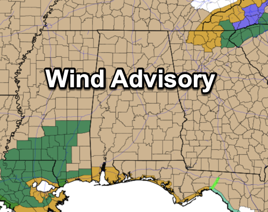
THE REST OF TODAY: A wind advisory has been issued for all of Alabama through tonight, while a High Wind Warning is in effect for the coastal counties. Before the storms arrive, gradient winds (not related to thunderstorms) will gust to 45/50 mph statewide late this afternoon, overnight, and into early tomorrow morning. This will bring potential for downed trees and power outages.
RAIN AND STORMS: The rain and storms will begin to arrive in Alabama later tonight, and will work through the state during the overnight hours. Rain amounts of 2-3 inches are likely through tomorrow morning, and some flooding issues are possible. As far as the storm threat for the northern half of Alabama, it is low, but not zero, due to lack on instability. For now, a “Marginal Risk” (level 1 of 5) of severe storms extends as far north as Reform, Tuscaloosa, Calera, Alexander City, and Auburn.
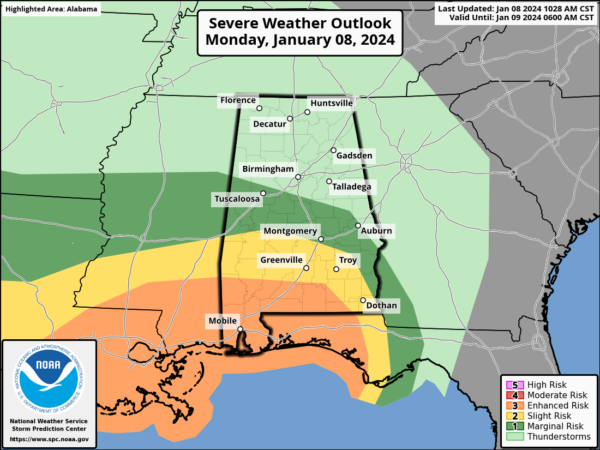
A few storms in these areas could produce damaging wind gusts, but for this event, the greatest threat of severe storms will be across South Alabama in the “Enhanced Risk” area.
CALL TO ACTION: For our friends and family in South Alabama, be ready to act immediately…Have multiple, reliable ways to receive severe weather alerts, NEVER, ever, ever rely on a siren. Every Alabama home and business needs a NOAA Weather Radio (the most popular model is the Midland WR-120, which is sold in most local big box retailers). The other way is your phone… be sure emergency alerts are enabled (look under settings, and notifications).
Know the safe place in your house, and in that safe place have helmets for everyone. Bicycle helmets and batting helmets work well. We also recommend portable air horns and hard soled shoes for everyone. If you live in an apartment complex, you can’t be above the first level. Shelter with a friend on the ground level, or ask management if they can open the clubhouse during a tornado warning.
If you live in a mobile home, you cannot stay there during a tornado warning, they offer little to know protection from severe storms. Know the location of the nearest shelter, or business that is open 24/7. Know how to get there quickly.
BE A HERO: You can help us. Tell your friends, neighbors, and relatives about the threat, and what they need to do to get ready. And, if they fall in a tornado warning polygon, call them or text them to let them know about the threat. You are our most valuable resource in spreading the word!
Many of you have anxiety about severe weather, especially those that have gone through tornadoes or other kinds of violent weather. Have comfort knowing that even on the biggest severe weather days, odds of any one home being hit by a tornado are very low. But, you have to pay attention and be prepared. We will get through the day together.
The rain tapers off statewide tomorrow morning; the day will be mostly cloudy and still windy with gusts to 30 mph possible during the afternoon hours. Temperatures will likely fall through the 40s over the northern 2/3 of the state as colder air arrives. For Wednesday and Thursday, sunny, dry weather is the story with highs in the 50s and 60s.
MORE STORMS FRIDAY: Another very dynamic system will bring more wind and rain to Alabama on Friday. The SPC has the southern 3/4 of the state in a severe weather risk in their “Day 5” Convective Outlook.
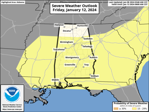
It looks like unstable air will extend farther north into the state for this event. Gradient winds will also be strong Friday, and rain amounts of 1-2 inches are likely. Let’s get through tonight’s event, and then we will focus on the end of week system in more detail.
THE ALABAMA WEEKEND: Saturday will be windy and sharply colder; temperatures will likely hold in the 30s over North Alabama, with 40s to the south. Temperatures should be well below freezing by Sunday morning. The weekend will be dry.
NEXT WEEK: We continue to see evidence the coldest air so far this season will roll into Alabama by the middle of next week, dropping lows into the teens over the northern half of the state. Before the cold air arrives, another dynamic weather system will bring rain and possible some storms back to Alabama, but has the potential to bring some wintry precipitation into Alabama Monday night or Tuesday. WAY too early to be specific, of course.
BEACH FORECAST CENTER: Get the latest weather and rip current forecasts for the beaches from Fort Morgan to Panama City on our Beach Forecast Center page. There, you can select the forecast of the region that you are interested in visiting.
WORLD TEMPERATURE EXTREMES: Over the last 24 hours, the highest observation outside the U.S. was 116.1F at Port Hedland Airport, Australia. The lowest observation was -67.2F at Yurty, Russia.
CONTIGUOUS TEMPERATURE EXTREMES: Over the last 24 hours, the highest observation was 84F at Big Pine Key, FL. The lowest observation was -15F at Havre, MT.
Category: Alabama's Weather, ALL POSTS
About the Author (Author Profile)
Macon, Georgia Television Chief Meteorologist, Birmingham native, and long time Contributor on AlabamaWX. Stormchaser. I did not choose Weather, it chose Me. College Football Fanatic. @Ryan_StinnetSubscribe
If you enjoyed this article, subscribe to receive more just like it.


