Midday Nowcast: Sunny and Cold Today; Severe Storms Return Friday
Alabama’s weather is dry today and tomorrow with a mix of sun and clouds. It is cold today with high in the upper 40s and lower 50s this afternoon. Tomorrow will be warmer, with 50s for North Alabama, and 60s to the south. These two days we are watching model and forecast trends as another round of strong to severe storms will impact Alabama on Friday.
SEVERE STORMS FRIDAY: Another high impact event is ahead for Alabama on Friday as another very dynamic storm system will bring the threat of severe thunderstorms statewide. The Storm Prediction Center has defined an “Enhanced Risk” (level 3/5) for much of East and Southeast Alabama… a “Slight Risk” (level 2/5) extends as far north as Winfield, Oneonta, and Gadsden, and the Tennessee Valley of North Alabama is in a “Marginal Risk” (level 1/5). The key message here is all of Alabama is under the threat of severe weather Friday.
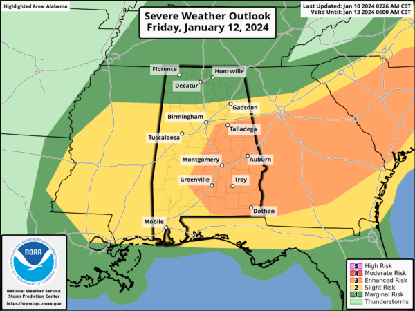
The biggest question with this system involves the amount of instability involved. For now it looks like there will be a narrow tongue of unstable air surging northward, and it will be sufficient for severe thunderstorm potential. Thunderstorms will be scattered and discrete in nature for this system and that does include the threat of supercells. Just a reminder, a supercell is a rotating thunderstorm.
Thunderstorms on Friday will be capable of producing damaging winds and few tornadoes. There is concern that this environment may support and maintain discrete supercell development with a risk for strong tornadoes, especially in the “enhanced risk” area across East and Southeast Alabama and is why this event has myself a bit more concerned than Monday night’s event. Again, each event is different, but this system has the potential to have a higher impact for portions of Alabama.
This will be a daytime event with storms entering and developing over West Alabama as early as 8AM. This threat will continue to through the daytime hours, and the storms should be exiting the state by 5PM. Stay tuned as the forecast will continue to evolve over the next couple of days.
Gradient winds (non-thunderstorm) will gust to 30/35 mph, but not as high as what we experienced with the system Monday night. Rain amounts should be around one inch with storms moving quickly, and being more scattered in nature.
WEEKEND WEATHER: Saturday will be windy and sharply colder; temperatures will likely hold in the 30s over North Alabama, with 40s to the south. Temperatures should be well below freezing by Sunday morning. The weekend will be dry.
ARCTIC FLOODGATES OPEN: Much colder air will enter Alabama Monday, and a disturbance will bring the chance of a cold rain, or maybe even some “wintry precipitation”, mostly in the form of freezing rain or sleet. We continue to stress it is simply too early to know if there will be any impact, and there is a chance we will just see a few periods of cold rain. When we get Friday’s system out of here, we can focus on Monday and be much more specific with a higher confidence forecast.
The most important message for next week is that the coldest air of the season will roll into the Deep South Monday night. By Tuesday morning, lows will be in the 10-15 degree range over the northern half of the state, with upper teens all the way down to Mobile and the I-10 corridor. The northern half of the state will stay below freezing all day Tuesday, and we drop into the teens again Wednesday morning. This will be similar to the cold wave we experienced in late December 2022. Hard freeze warnings will be required; make plans now. See the video briefing for maps, graphics, and more details.
BEACH FORECAST CENTER: Get the latest weather and rip current forecasts for the beaches from Fort Morgan to Panama City on our Beach Forecast Center page. There, you can select the forecast of the region that you are interested in visiting.
WORLD TEMPERATURE EXTREMES: Over the last 24 hours, the highest observation outside the U.S. was 118.2F at Marble Bar, Australia. The lowest observation was -68.3F at Yurty, Russia.
CONTIGUOUS TEMPERATURE EXTREMES: Over the last 24 hours, the highest observation was 82F at numerous locations across Florida. The lowest observation was -10F at Alamosa, CO.
Category: Alabama's Weather, ALL POSTS
About the Author (Author Profile)
Macon, Georgia Television Chief Meteorologist, Birmingham native, and long time Contributor on AlabamaWX. Stormchaser. I did not choose Weather, it chose Me. College Football Fanatic. @Ryan_StinnetSubscribe
If you enjoyed this article, subscribe to receive more just like it.


