Storms Intensifying Tonight Over Arkansas
Storms over Arkansas are growing in coverage and intensity tonight around what appears to be an upper-level disturbance northwest of Little Rock.
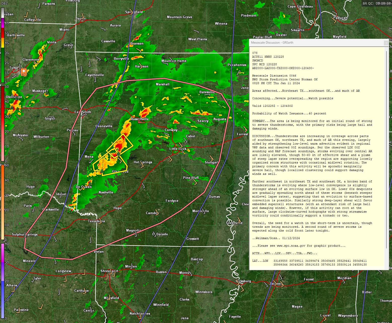
A line of storms is developing from Russellville to east of Mena to near DeQueen.
A severe thunderstorm warning was in effect a short time ago for Van Buren, Yell, Pope, and Conway counties northwest of Little Rock. Two new are now in effect for parts of Garland, Montgomery, Pike, Polk, Yell, and Scott counties west of Hot Springs.
Ahead of it, numerous storms cover the central part of the state in the warm advection pattern out in front of the cyclone, which is located near Wichita Falls Texas. A warm front is lifting north through southern parts of that state.
The storms are working with about 300-700 joules of CAPE, and that instability will continue to increase. Bulk shear values are off the chart, running near 70 knots. This will allow for organized and possibly discrete cells overnight. The threat for tornadoes will increase with storm relative helicity values over 450 m2/s2.
The SPC just issued an MCD and puts the probability of a watch at about 40 percent.
The current storms will lift into Missouri, Illinois, Kentucky, and Indiana over the next several hours.
A line of storms will form over the next few hours over Western Arkansas ahead of a cold front. Those storms will approach the Mississippi River between 7-8 a.m.
Showers and storms will break out over Mississippi after midnight and across Alabama after 3 a.m. Thunder will become widespread over western Alabama between 6-8 a.m.
The line of storms should weaken a bit over eastern Mississippi, but it will begin to rebound as it moves into Alabama between 9-10 a.m. It will reach Birmingham around 11:30 a.m.-12:30 p.m. It will pass out of eastern Alabama by 4 p.m.
The apex of instability will cross Alabama in a wave starting around 10 a.m. that will be localized to areas south of a line from Winfield to Springville to Heflin. Those CAPE values are expected to be around 1,000 joules.
Significant tornado values become pretty high from Pickens through Greene, Hale, Tuscaloosa, Jefferson, Bibb, Shelby, Talladega, and Chilton counties, and that is somewhat concerning.
The limiting factor will be modest low level moisture. That could completely limit the storms.
There will be a meager amount of instability across North Central Alabama in the afternoon as skies clear at least partially, and that instability could squeeze out a few showers, but not likely storms.
Lows tonight will be in the 40s across the area with a few 30s in the Northeast part of the state. Highs tomorrow iwll be in the lower 60s north of I-20, with middle and upper 60s near and south of I-20.
In addition to the storms, winds will increase overnight, gusting to 30 mph by morning over western sections, and 15-20 mph over eastern sections. Winds will increase with gusts to 50 mph by noon across the areas. As we saw Monday night and Tuesday, these kids of winds will cause tree limbs and entire trees to be felled, bringing down power lines and causing power outages. Be very careful with the storms, and with the strong gradient winds.
Many businesses and schools are closed or have virtual days tomorrow, which is exercising caution.
We will have frequent updates tomorrow starting with James’ video before 6 a.m. and throughout the day until we get the storms out of the state.
Have your weather sources ready and on alert all day tomorrow starting at 7 a.m.
Category: Alabama's Weather, ALL POSTS, Severe Weather
About the Author (Author Profile)
Bill Murray is the President of The Weather Factory. He is the site's official weather historian and a weekend forecaster. He also anchors the site's severe weather coverage. Bill Murray is the proud holder of National Weather Association Digital Seal #0001 @wxhistorianSubscribe
If you enjoyed this article, subscribe to receive more just like it.


