Some Housekeeping Items at 3:30 pm: Winter Storm Warning for all of the Tenn. Valley; Advisory Posted for Southwest Alabama
A few updates have occurred to the warnings and advisories. Here is the latest map:
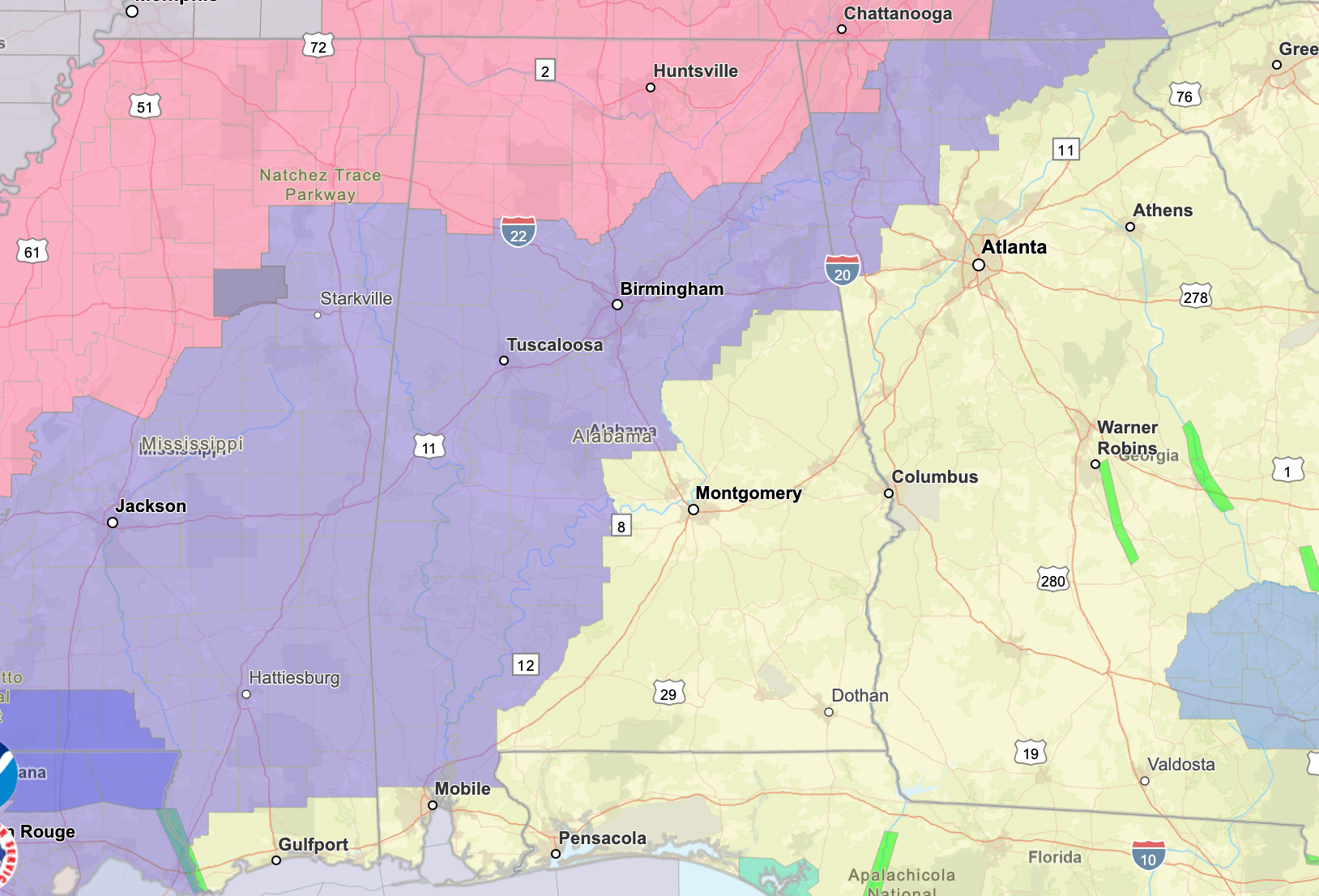
The Winter Storm Warnings are in Magenta and the Winter Weather Advisory is in Purple.
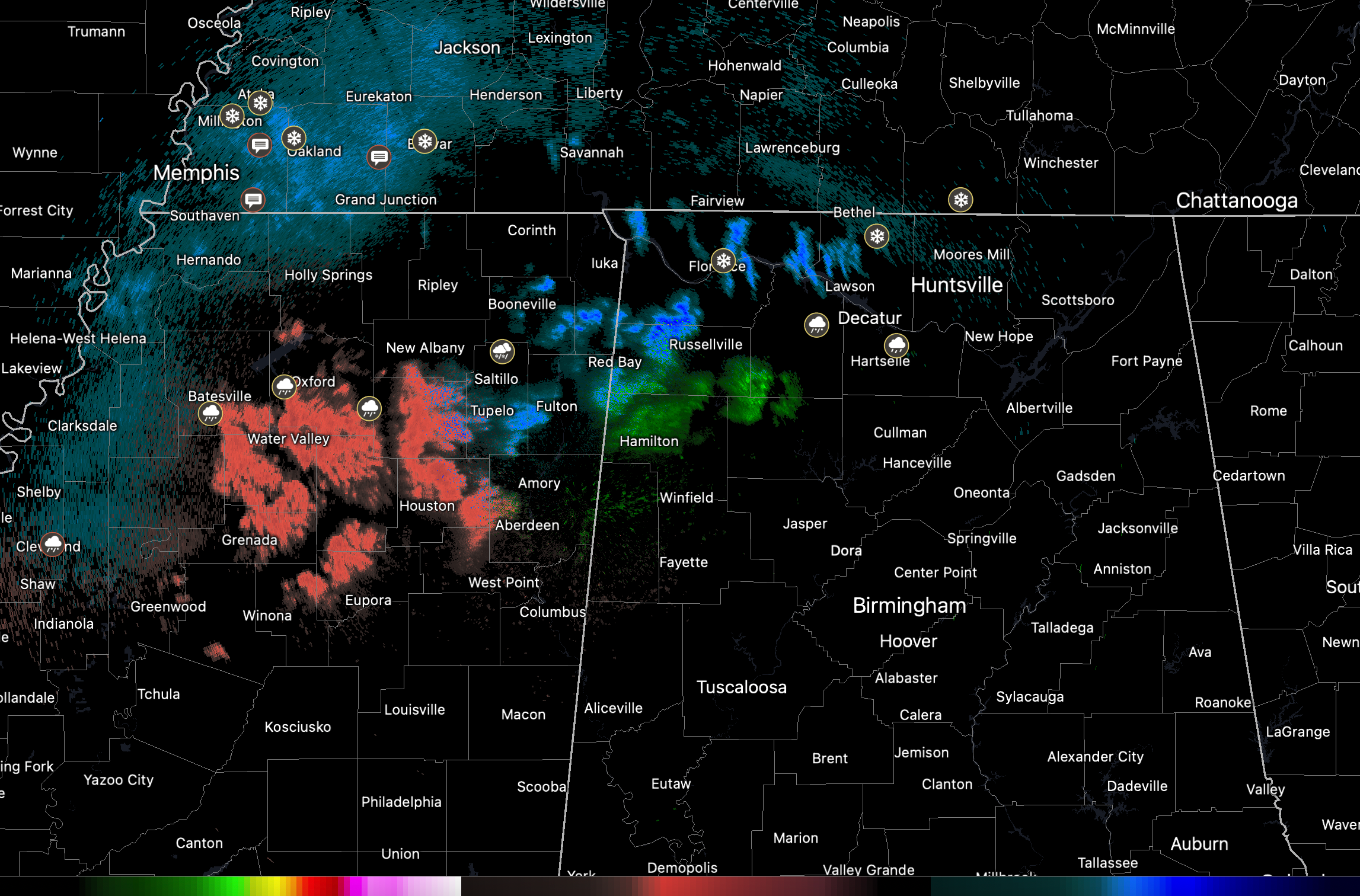
Flurries and sleet are moving into the Tennessee Valley a little earlier than expected.
The NWS in Huntsville has upgraded their entire 11 county area to a Winter Storm Warning and started it earlier. It will go into effect at 6 p.m. CST. It is set to expire at 6 a.m. Tuesday.
SLEET REPORT
…Patrick Nagel in Rogersville in Lauderdale County in Northwest Alabama shared a photo of sleet accumulating on top of a car there.
The NWS Mobile has posted a Winter Weather Advisory for some of their counties:
ALZ051>055-261-262-MSZ067-075-076-078-079-150530-
/O.NEW.KMOB.WW.Y.0001.240116T0300Z-240116T1500Z/
Choctaw-Washington-Clarke-Wilcox-Monroe-Mobile Inland-
Baldwin Inland-Wayne-Perry-Greene-Stone-George-
Including the cities of Butler, Lisman, Silas, Chatom, Millry,
Grove Hill, Jackson, Thomasville, Camden, Pine Hill, Homewood,
Monroeville, Citronelle, Saraland, Stockton, Waynesboro,
Beaumont, New Augusta, Richton, Leakesville, McLain, Wiggins,
and Lucedale
323 PM CST Sun Jan 14 2024
…WINTER WEATHER ADVISORY IN EFFECT FROM 9 PM MONDAY TO 9 AM CST
TUESDAY…
* WHAT…Freezing rain expected. Total ice accumulations of a
light glaze.
* WHERE…Portions of south central and southwest Alabama and
southeast Mississippi.
* WHEN…From 9 PM Monday to 9 AM CST Tuesday.
* IMPACTS…Roads, and especially bridges and overpasses, will
likely become slick and hazardous. The hazardous conditions
could impact the morning commute.
PRECAUTIONARY/PREPAREDNESS ACTIONS…
Delay all travel if possible. If travel is absolutely necessary,
drive with extreme caution and be prepared for sudden changes in
road conditions. Leave plenty of room between you and the vehicle
ahead of you. Allow extra time to reach your destination. Avoid
sudden braking or acceleration and be especially cautious on hills
or when making turns.
Freezing rain remains possible late Monday night into Tuesday morning northwest of Interstate 65 as a cold front crosses the area. Cold air moving over the area behind the front will limit temperatures to the upper 30s to mid 40s over most of the area Tuesday. The continued push of cold air will bring temperatures dropping into the teens and winds chills in the single digits to most of the area Tuesday night into Wednesday morning.
Category: Alabama's Weather, ALL POSTS, Winter Weather
About the Author (Author Profile)
Bill Murray is the President of The Weather Factory. He is the site's official weather historian and a weekend forecaster. He also anchors the site's severe weather coverage. Bill Murray is the proud holder of National Weather Association Digital Seal #0001 @wxhistorianSubscribe
If you enjoyed this article, subscribe to receive more just like it.


