Update on the Alabama Weather Situation at 12:10 pm
Travel conditions are not good across much of North Alabama at this hour…
Joshua Whitcomb at Jackson County EMA reports multi-vehicle accident on highway 72 at Broad Street in Scottsboro. Another accident on highway 72 at highway 35 in Woodville. Roads are incing over quickly in the area he reports.
Cullman roads are icy. Many issues there.
Bridges in Huntsville are already icy.
And more heavy snow is poised to move across the Tennessee Valley over the next few hours. Here is radar.
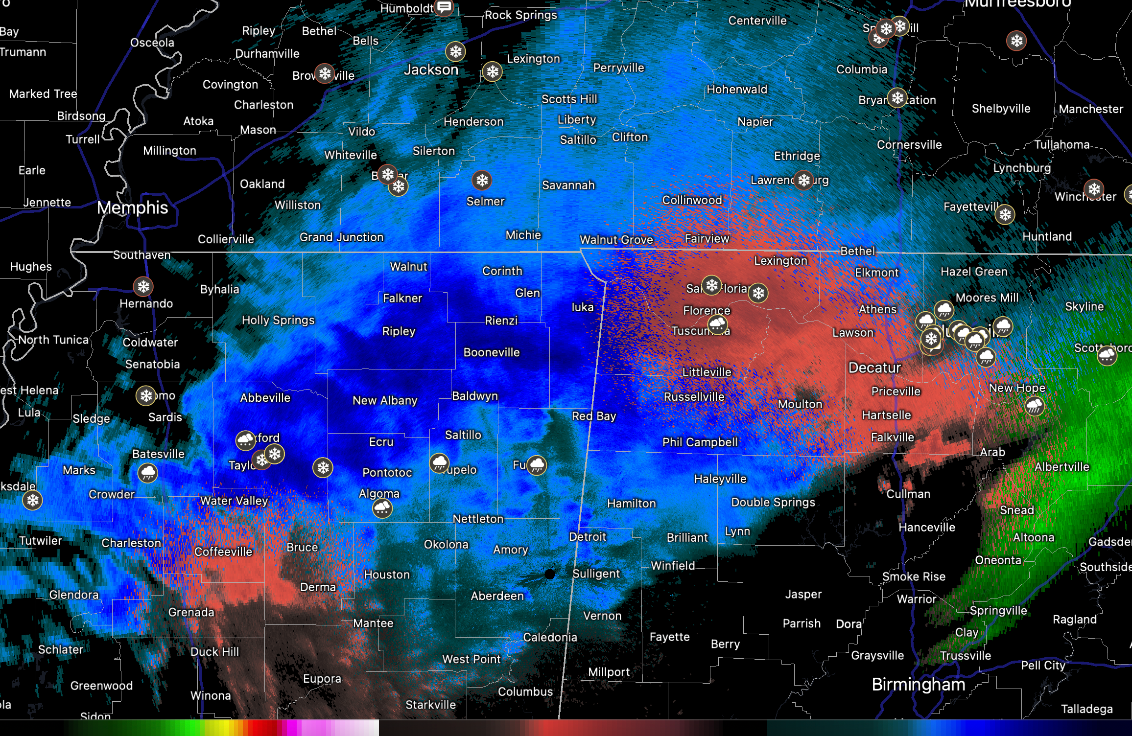
From Andy Kula at the NWS Huntsville: Radar is showing an area of accumulating sleet mixed with snow over MS heading into northwest AL. This will continue tracking east-northeast through the rest of north AL over the next 1-4 hours. The northwest end of this precipitation may be all snow including the Shoals into southern middle TN. However, southeast of this line, the precipitation will come in the form of sleet mixed with snow.
There will be some impressive snow totals over Northwest Alabama with 4-8+ across western Colbert and Lauderdale counties. 1-2 inches will fall as far south as a line from Vina to Priceville to Section. South of that, mostly a glaze of freezing rain with some isolated snowfalls of a dusting to one inch.
A wintry mix of snow, sleet, and freezing rain will drop south over the next few hours across parts of Pickens, Lamar, northern Tuscaloosa, Walker, NW Jefferson, Blount, Marshall, DeKalb, and Cherokee Counties.
The freezing rain will reach Tuscaloosa – Birmingham and Gadsden starting by late afternoon, aroun 6-7 p.m. continuing until well after midnight. Freezing rain accumulation s will reach between 0.10-0.25 inches, which is sufficient to ice all bridges and cause very dangerous driving conditions.
The activity will push into areas southeast of the Tuscaloosa – BHM – Anniston line during the late evening and conitnuing into the pre-dawn hours.
A hard freeze warning is in effect for North and much of Central Alabama for tinight and for all of the area tomorrow night. This is where temperatures are expected to be 20 degrees or colder. Protect People, Pets, and Pipes. Be careful with any space heaters.
Elsewhere…interstates are snow covered in Nashville. Travel is highliy discouraged across much of North Alabama and Tennessee in the Winter Storm Warning areas.
Interestingly, there could be some Lake Effect Snows of all things downind of the relatively warmer reservoirs and lakes of the Tennessee Valley tomorrow!
Things are not much better in Texas. Tyler has icy roads. ERCOT is concerned that they may not be able to keep up with power demand and people are being asked to conserve.
Category: Alabama's Weather, ALL POSTS, Winter Weather
About the Author (Author Profile)
Bill Murray is the President of The Weather Factory. He is the site's official weather historian and a weekend forecaster. He also anchors the site's severe weather coverage. Bill Murray is the proud holder of National Weather Association Digital Seal #0001 @wxhistorianSubscribe
If you enjoyed this article, subscribe to receive more just like it.


