Midday Nowcast: Dangerously Cold Air Dropping into Alabama
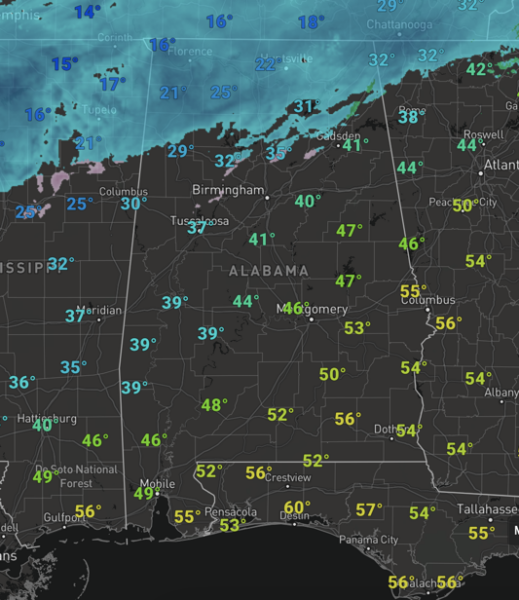
Dangerously cold Arctic air is dropping south into Alabama today brining the coldest air since December 2022 to Alabama and the Deep South. We are seeing quite the temperature gradient across the state with teens in the Tennessee Valley, and mid to upper 50s across South Alabama. More on the cold in a minute, let’s talk about the snow and ice we are seeing today and tonight.
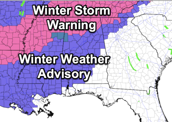
Light to moderate snow continues to fall across the northern third of the state today. A Winter Storm Warning remains in effect for Marion, Winston, Franklin, Colbert, Lauderdale, Lawrence, Limestone, Cullman, Morgan, Madison, Marshall, Jackson, and DeKalb counties in North Alabama. Roads will be icy and hazardous there. A Winter Weather Advisory is in effect west of a line from Mobile to Selma to Clanton to Sylacauga to Ranburne.
Most of the accumulating snow will come along and north of the Tennessee River where 2-4 inch totals are possible. Amounts over 5 inches are possible around the Shoals before it ends tonight. Light snow accumulation is possible as far south as Hamilton, Cullman, and Fort Payne.
For the rest of the winter weather advisory area, freezing rain and drizzle are the primary issue. This is precipitation that falls in liquid form when surface temperatures are below 32 degrees, it then freezes, bringing a glaze of ice to exposed surfaces, including bridges and some roads and will cause hazard driving conditions.
Once the temperatures fall below freezing at your location, it will remain below freezing all day tomorrow and through the late morning hours Wednesday, so travel conditions won’t improve much until then.
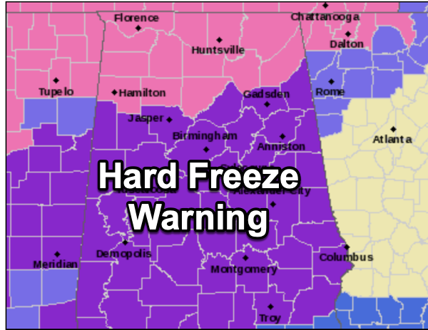
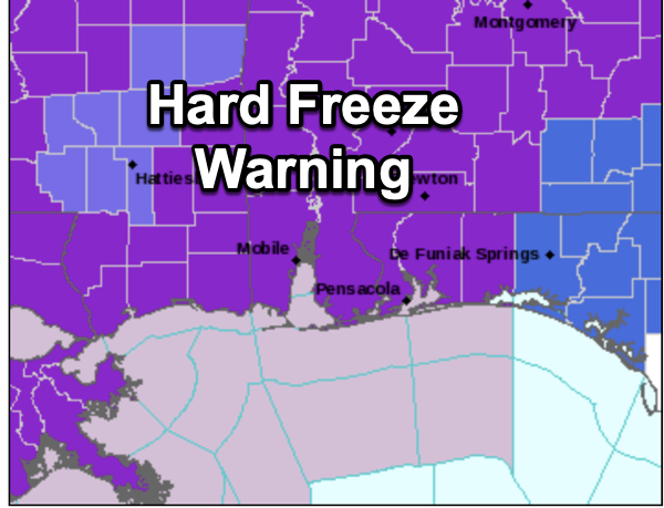
Now too the cold..A Hard Freeze Warning is now in effect for nearly all of Alabama, even down to the beaches of the Northern Gulf Coast. Temperatures drop into the teens tonight, remain below freezing tomorrow, and drop into the single digits and teens Tuesday night.
To add insult to injury, wind chills will be very low, below zero at times tomorrow, tomorrow night, and early Wednesday.
Remember the 4Ps: People, Pets, Pipes, and Plants.
Prolonged sub-freezing temperatures may cause pipes to burst. Bitterly cold temperatures and wind chills can result in hypothermia or frostbite quickly. These conditions are life-threatening to those with prolonged exposure or without access to warmth.
Check on those who may not have adequate heating and bring pets inside. Pipes will need to be properly wrapped, and you will need to keep pipes dripping/running during the overnight hours to hopefully prevent bursting. Learn how to shut off water valves for potential pipe bursts.
REST OF THIS WEEK: Wednesday will be sunny, with highs in the mid to upper 30s. Temperatures rise into the upper 40s and low 50s Thursday, but another batch of Arctic air invades the state Thursday night and Friday. Again, there is the chance for some “winter weather mischief” over the northern third of the state Thursday night. For most of the state it will be just a cold light rain at times, but let’s get through the next 24-36 hours, and will focus on the next system in future forecasts.
NEXT ARCTIC BLAST: The sky will clear on Friday with highs only in the 30s over the northern half of the state. A brisk north wind will make it feel colder. The weekend will feature more dangerously cold temperatures for Alabama. Lows will be in the teens for most places Saturday and Sunday morning. North Alabama will stay below freezing all day Saturday. Temperatures rise into the 40s Sunday afternoon as we begin to climb out of the deep freeze.
INTO NEXT WEEK: Good nows, the weather pattern flips, and we will be in the 60s by mid-week, with signs of rain showing up in the long range models for the second half of the week.
BEACH FORECAST CENTER: Get the latest weather and rip current forecasts for the beaches from Fort Morgan to Panama City on our Beach Forecast Center page. There, you can select the forecast of the region that you are interested in visiting.
WORLD TEMPERATURE EXTREMES: Over the last 24 hours, the highest observation outside the U.S. was 110.1F at Wulungurru, Australia. The lowest observation was -69.7F at Delyankir, Russia.
CONTIGUOUS TEMPERATURE EXTREMES: Over the last 24 hours, the highest observation was 81F at Falcon Village, TX. The lowest observation was -37F at Rocky Boy, MT.
Category: Alabama's Weather, ALL POSTS, Winter Weather
About the Author (Author Profile)
Macon, Georgia Television Chief Meteorologist, Birmingham native, and long time Contributor on AlabamaWX. Stormchaser. I did not choose Weather, it chose Me. College Football Fanatic. @Ryan_StinnetSubscribe
If you enjoyed this article, subscribe to receive more just like it.


