Saturday Briefing — Old Man Winter is Fixin’ to Be on Vacation

OLD MAN WINTER REFUSES TO LEAVE THIS WEEKEND
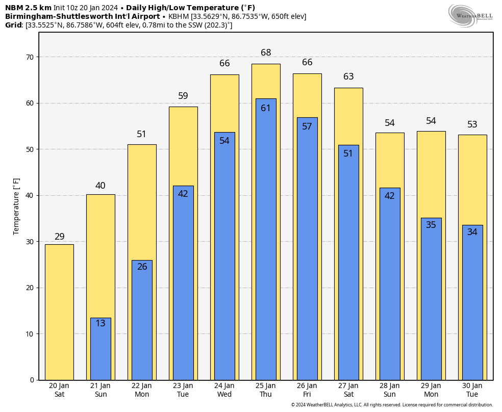
When the sun rises on Saturday morning, temperatures will be down in the lower teens to the lower 20s across the area, and all 39 counties in the CWA of NWS Birmingham will be under a Hard Freeze Warning until noon. Wind chills may drop as low as -5º, and a Wind Chill Advisory is up for Blount, Calhoun, Cherokee, Cleburne, Etowah, Fayette, Lamar, Marion, St. Clair, Walker, and Winston counties in Central Alabama until 9am, and for all of NWS Huntsville’s CWA until Sunday 9am. Skies will be mainly sunny with highs only range from the mid 20s to the lower 40s from northwest to southeast.
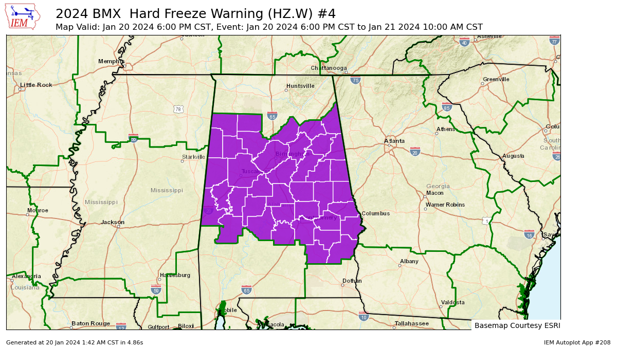
Another Hard Freeze Warning will start Saturday evening for those same Central Alabama counties, and go until 9am Sunday as early morning lows bottom out in the upper single digits to the upper teens. The good news is that we’ll have tons of sunshine through the day on Sunday and highs will top out in the upper 30s to the mid 40s.
WARMING TREND STARTS WITH SOME RAIN MIXED IN
A pattern shift begins on Monday as we transition from below normal temperatures to above normal through the work week ahead. Skies will be mostly sunny to start on Monday, but clouds will begin to increase late, and a stray shower will be possible after midnight. Highs in the upper 40s to the upper 50s.
With a southwesterly flow across the area, we’ll have a few waves move into and across Central Alabama during the work week. Tuesday will feature mostly cloudy skies and a good chance of showers through the day, with rain likely during the evening and overnight with some thunder. Highs in the mid 50s to the mid 60s. Rain and a few storms will continue at times through the day on Wednesday, but that thermometer will continue to rise as highs reach the lower 60s to the lower 70s. Same story on Thursday with highs in the mid 60s to the lower 70s.
And at the end of the forecast period, we continue to see that rain will be likely again on Friday, with some thunder possible. Highs back off just a tad, but staying mild in the lower 60s to the lower 70s.
TEMPERATURE AND RAIN OUTLOOK
For now, we do not see a big deviation in temperatures after the end of the forecast period, as highs only drop back a few degrees into the 50s and 60s.
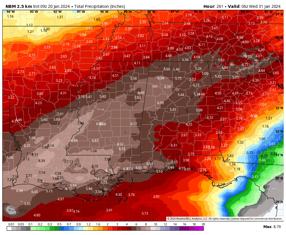
We look to get some decent rainfall as well as we are seeing projections up in the 5-6 inch range for a good portion of North and Central Alabama, with the rest of the state looking at the potential of 3–4 inches. This will definitely help out in the drought category.
ON THIS DAY IN WEATHER HISTORY
1990… While heavy thunderstorm rains drenched the Central Gulf Coast States, with 4.23 inches reported at Centreville AL in 24 hours, unseasonably warm weather continued across Florida. Five cities in Florida reported record high temperatures for the date. Tampa FL equaled their record high for January of 85 degrees.
BEACH FORECAST
Get the latest weather and rip current forecasts for the beaches from Dauphin Island, AL, to Panama City Beach, FL, on our Beach Forecast Center page. There, you can select the forecast of the region that you are interested in.
Category: Alabama's Weather, ALL POSTS, Weather Xtreme Videos
About the Author (Author Profile)
Scott Martin is an operational meteorologist, professional graphic artist, musician, husband, and father. Not only is Scott a member of the National Weather Association, but he is also the Central Alabama Chapter of the NWA president. Scott is also the co-founder of Racecast Weather, which provides forecasts for many racing series across the USA. He also supplies forecasts for the BassMaster Elite Series events including the BassMaster Classic.Subscribe
If you enjoyed this article, subscribe to receive more just like it.


