Sunday Weather Briefing Video: January Thaw Ahead
Alabama is experiencing an exceptional weather pattern, with frigid cold gripping the state in the short term and a gradual thawing trend expected in the days to come. The National Weather Service continues cold weather warnings and advisories as the region grapples with an invasion of arctic air, resulting in below-freezing temperatures and dangerously low wind chills.
THE CURRENT CHILL: Alabama residents woke up to a harsh reality Saturday as Birmingham, Huntsville, and Mobile all felt the brunt of this cold snap. On a bitterly cold Saturday morning, Central Alabama awoke to frigid temperatures that emphasized the grip of winter’s chill. In Tuscaloosa, the thermometer plummeted to a bone-chilling low of 19°F, while nearby Birmingham reported an equally frosty low of 18°F. Anniston joined the ranks of the cold with a morning low of 19°F. Across Central Alabama, lows ranged from 12F at Haleyville to 27F at Eufaula. South Alabama’s coldest was 22F at Greenville and Grove Hill.
The bitter cold is courtesy of a sprawling 1042mb ridge of high pressure centered over the Ohio Valley this morning, which has allowed arctic air to flood the Southeast. Saturday afternoon temperatures remained below freezing across much of the state, with even colder wind chills due to gusty northerly to northwest winds between 10 and 20 mph. None of the Birmingham area stations got above 32F and Tuscaloosa only made it to 34F.
Lows this morning are between 8-10F across the Tennessee Valley, with 11-17F across Central Alabama and 17-21F across South Alabama. Mobile and Gulf Shores will drop to around 25F.
WARNINGS AND ADVISORIES: NWS Offices in Birmingham, Montgomery, and Tallahassee have issued Hard Freeze Warnings for all of their counties in Alabama, emphasizing the risk of freezing pipes, damage to sensitive vegetation, and the need to protect outdoor pets from the extreme cold. The only exceptions are the coastal zones of Mobile and Baldwin Counties. Wind Chill Advisories are in effect through this morning across both the northern third and southern third of Alabama, where wind chill values through this morning will be between 6-11F across North Alabama, with values between 11-21F across Central Alabama, and in the 20s across South Alabama.
THE JANUARY THAW: Fortunately, a feature of January is almost always that we experience a nice thaw after any really cold period. It is a real thing climatologically. The good news is that one of those thawing trends is on the horizon. As the upper ridge axis shifts eastward on Sunday, upper-level ridging will take over the region, allowing the arctic air to modify. This means that we will finally rise above freezing areawide on Sunday afternoon, ranging from the upper 30s in the northwest to the mid-40s in the south, all under plenty of sunshine. While temperatures will remain chilly, this trend represents a step in the right direction to begin thawing out after days of extreme cold.
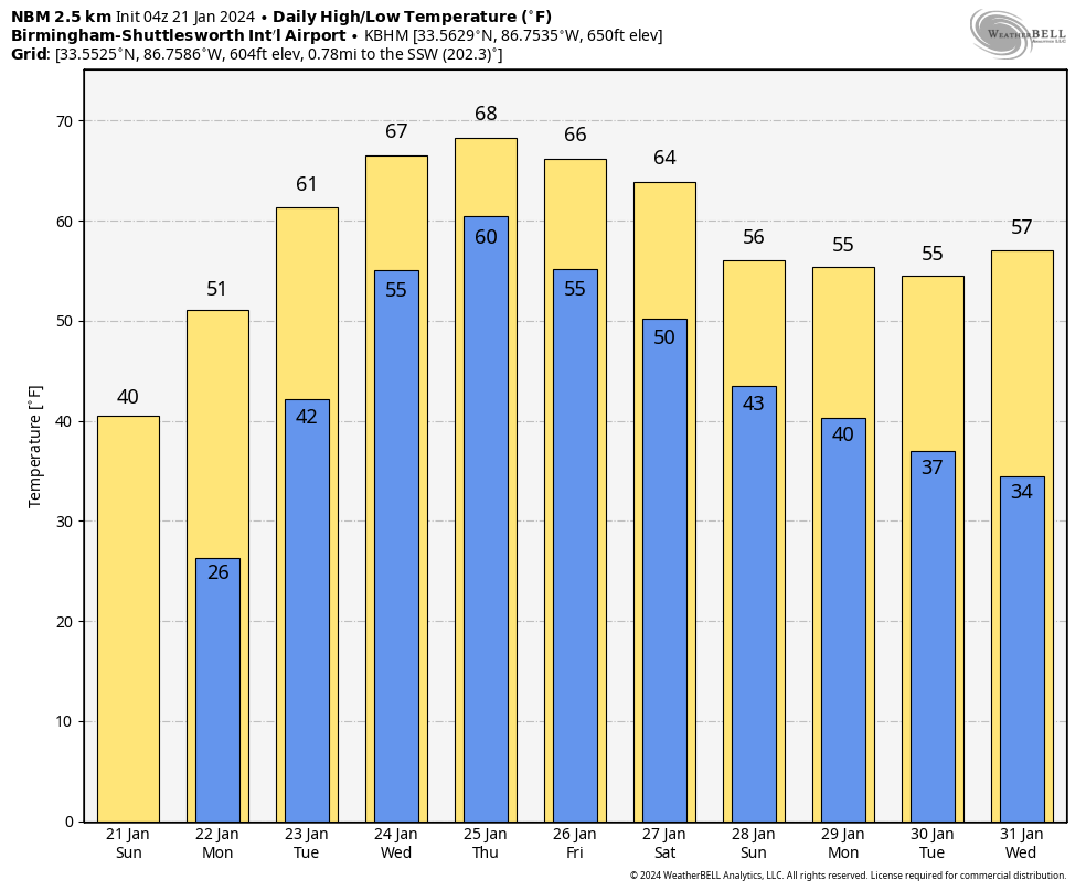
THE WEEK AHEAD: Looking beyond the short term, Alabama can expect a shift in weather patterns. Next week promises a departure from the frigid conditions with a period of warmer, unsettled weather. Rain chances are on the horizon, beginning on Tuesday and persisting through at least Friday, and perhaps into Saturday.
Multiple rounds of showers and thunderstorms are possible, with potential rainfall totals ranging from 2 to 5 inches. Diurnal temperatures will gradually increase each day, offering a welcome reprieve from the extreme cold. Highs will gradually warm from near 50F Monday, into the middle 60s through Friday. Lows will go from the 40s Monday night, into the 50s Tuesday night, and 60s by Wednesday night. Those lows will trend back into the 50s Thursday and Friday night.
The forecast scenario favors the potential for thunderstorms and locally heavy rainfall, particularly on Wednesday and Thursday when precipitable water values approach 2 inches, which will be some 200-300% above normal. Flooding is a concern, and we will be closely monitoring the situation. The potential for severe weather is low across Alabama and the Deep South, as instability will be limited.
HOW ABOUT THE WEEKEND?: As I hinted earlier, the rain will reluctantly leave on Saturday. Highs will still be in the 60s on Saturday, but will fall back into the 50s on Sunday. Lows will drop back into the 40s Sunday morning and 30s Sunday night.
VOODOO TERRITORY: That change back to colder will be the result of the passage of another full latitude trough that will be swinging though the East. That frontal system may bring a few snow showers to Tennessee and rain or snow showers to the Tennessee Valley on Monday the 29th. The end of the period, around February 3rd and 4th looks really wet and stormy across Alabama with at least two big waves of moisture coming through the state. There does look like there will be some instability involved on Sunday the 4th, so severe weather will not be out of the question.
RAIN TOTALS: Two week rainfall amounts across Alabama look pretty impressive, with widespread 4-5 inch amounts across much of the state. There could be as much as 8 inches in parts of Northwest and South Alabama.
BEACHCAST: After a beautiful but cold weekend, rain will return Monday night. And it will wear out its welcome as they week goes by. Apparently, it heard that if you pay for a week you can get a discount, cause the latest word is that it won’t check out until next Saturday night. At least temperatures will be nicer, with 60s Monday through the end of the week. Lows will warm into the 50s to near 60F. Water temperatures have taken a hit with this past week’s cold spell, and are now in the middle 50s. A high rip current risk will be present starting Monday though.
Click here to see the Beach Forecast Center page.
DANCING WITH THE STATS: Some amazing lake effect snow totals in New York over six days between the 13th and 18th. 80.4” fell in West Seneca, with 74.2” in Hamburg. Buffalo, NY picked up 61.5” of snow. The culprit has been warmer than normal lake waters, along with below normal ice coverage. The ice coverage on Lake Erie has jumped from 1% to 12% just in the past week.
ADVERTISE WITH US: Deliver your message to a highly engaged audience by advertising on the AlabamaWX.com website. We have a lot of big plans for this year. Don’t miss out! We can customize a creative, flexible, and affordable package that will suit your organization’s needs. Contact me, Bill Murray, at (205) 687-0782 and let’s talk.
WEATHERBRAINS: This week, the panel will chat with Hurricane Expert Mark Sudduth. We will talk about the 2023 hurricane season, and his plans for 2024. We will primarily, though, focus on the impacts that his parents played in following his passions. I guarantee you there will be some great lessons, and some tears. Check out the show at www.WeatherBrains.com. You can also subscribe on iTunes. You can watch the show live on our new YouTube channel for the show.You will be able to see the show on the James Spann 24×7 weather channel on cable or directly over the air on the dot 2 feed.
ON THIS DATE IN 1940: Birmingham was in the middle of its coldest 14-day period on record The average temperature from the 18th through the 31st was 22.5F. Single digit lows were reported on 6 of the mornings and 3 days never got above 20F. Follow my weather history tweets on Twitter. I am @wxhistorian at Twitter.com.
Category: Alabama's Weather, ALL POSTS, Winter Weather
About the Author (Author Profile)
Bill Murray is the President of The Weather Factory. He is the site's official weather historian and a weekend forecaster. He also anchors the site's severe weather coverage. Bill Murray is the proud holder of National Weather Association Digital Seal #0001 @wxhistorianSubscribe
If you enjoyed this article, subscribe to receive more just like it.


