A Quick Preview of What to Expect With the Weather This Week
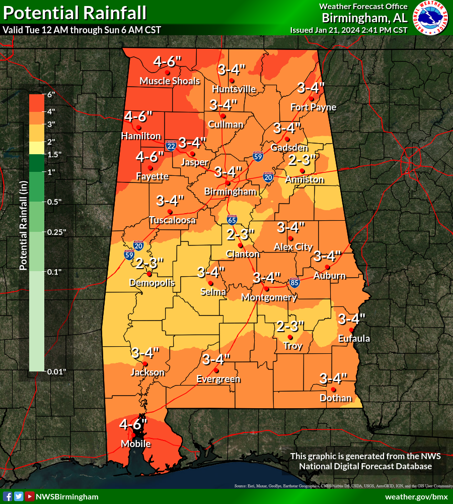
RAINFALL TOTALS FOR THE WEEK AHEAD
If this week plays out to what the forecast models are currently projecting, we could see some good rainfall totals to help make a big dent in our drought situation. However, rainfall could be heavy enough during the latter half of the week to cause some flooding issues. We could see rainfall amounts reach as much as 2–6 inches across the state, with the higher totals down near the Gulf Coast and up in the northwestern quarter.
WARMER; SOME POTENTIAL OF FLOODING THIS WEEK
A pattern shift begins on Monday as we transition from below normal temperatures to above normal through the work week ahead. We’ll start off with early morning lows in the 20s across the area, but that may be the last time we see sub-freezing temperatures through the end of the month. Skies will be mostly sunny to start, but clouds will begin to increase late, and a stray shower will be possible after midnight. Highs in the 50s.
With a southwesterly flow across the area, we’ll have a few waves move into and across Central Alabama during the work week. Tuesday will feature mostly cloudy skies and a good chance of showers through the day, with rain likely during the evening and overnight hours. Highs in the upper 50s to the upper 60s. Rain and a few storms will continue at times through the day on Wednesday, but that thermometer will continue to rise as highs reach the lower 60s to the mid 70s.
Thursday will be the day that we could see some flooding issues as rainfall could be heavy at times. WPC has placed nearly all of North and Central Alabama in a slight risk for excessive rainfall, which means there is the potential for a few localized flash flooding issues as a front will stall out over the area. We may continue to have those issues on Friday as well as rain and some thunder will continue at times through the day. Thursday will be in the mid 60s to the mid 70s, while Friday drops a couple of degrees into the lower 60s to the lower 70s.
And at the end of the forecast period, we continue to see that rain will be likely again on Friday, with some thunder possible. Highs back off just a tad, but staying mild in the lower 60s to the lower 70s.
THE CENTRAL ALABAMA WEEKEND
We continue to have a good chance for showers and storms on Saturday, but the stalled front will finally get a push it needs to make it through the rest of the area, and we dry out for Sunday. Saturday’s highs will be in the upper 50s to the lower 70s, with Sunday’s highs in the upper 40s to the lower 60s.
Category: Alabama's Weather, ALL POSTS
About the Author (Author Profile)
Scott Martin is an operational meteorologist, professional graphic artist, musician, husband, and father. Not only is Scott a member of the National Weather Association, but he is also the Central Alabama Chapter of the NWA president. Scott is also the co-founder of Racecast Weather, which provides forecasts for many racing series across the USA. He also supplies forecasts for the BassMaster Elite Series events including the BassMaster Classic.Subscribe
If you enjoyed this article, subscribe to receive more just like it.


