

Midday Nowcast: Showers Today; Heavier Rainfall Ahead
CLOUDY, SOME SHOWERS: The Alabama sky is full of clouds today and we continue to see some areas of rain across the state. These areas of rain will continue the next few hours, but should decrease in coverage this afternoon. Today is warmer with afternoon highs in the upper 50s and lower 60s.
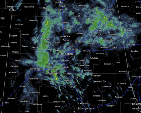
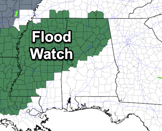
WET AND STORMY REST OF WEEK: Widespread rain and some storms are likely tomorrow, Thursday, and into Friday. The rain could be heavy at times, and a flood watch has been issued for all areas along and north of Interstate 20.
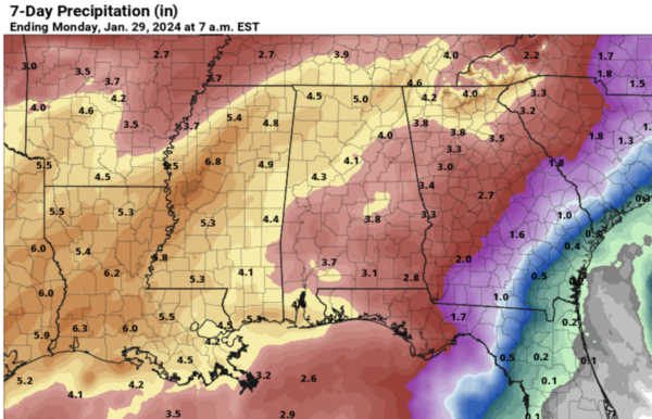
Rain amounts of 3-5 inches are likely between now and Saturday night across the state, with isolated amounts over 6 inches possible over the northern counties.
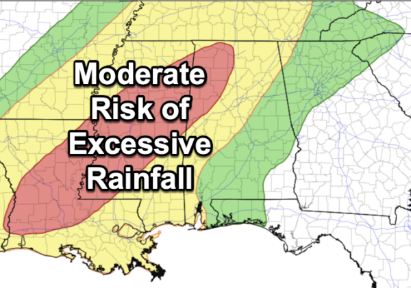
This could lead to some flooding issues. The Weather Prediction Center has issued a moderate risk of excessive rainfall the next couple of days across portions of Northwest Alabama. These would be the areas where flooding concerns are the highest.
Despite the clouds and rain, temperatures will be above average all week with afternoon highs in the mid and upper 60s, with even some low 70s possible.
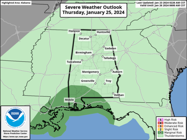
Some storms are possible, but the best chance of strong thunderstorms will be across South Alabama tomorrow and Thursday… heavier storms there could produce strong gusty winds. Portions of South Alabama is in a “marginal risk” (level 1/5) of severe thunderstorms Thursday.
We should see a break in the rain for Friday afternoon and night before another round of rain moves in on Saturday.
MORE STORMS SATURDAY: Saturday will be a mild and breezy day and another wave of every will move across Alabama. There will likely be some surface based instability available, and strong storms are possible statewide. Too early to know if severe thunderstorms will be an issue, but it is certainly is possible. Something will continue to watch over the next few days. Highs Saturday will remain in the 60s ands 70s.
SUNDAY AND NEXT WEEK: Dry air returns to Alabama on Sunday, with a partly sunny sky along with highs in the 50s, right at seasonal values for late January. For now much of the week the weather looks dry with highs mostly in the 50s, and lows in the 30s. This should give us a chance to dry out after the soggy pattern this week.
BEACH FORECAST CENTER: Get the latest weather and rip current forecasts for the beaches from Fort Morgan to Panama City on our Beach Forecast Center page. There, you can select the forecast of the region that you are interested in visiting.
WORLD TEMPERATURE EXTREMES: Over the last 24 hours, the highest observation outside the U.S. was 117.0F at Onslow Airport, Australia. The lowest observation was -69.9F at Delyankir, Russia.
CONTIGUOUS TEMPERATURE EXTREMES: Over the last 24 hours, the highest observation was 82F at Rio Grande Village, TX. The lowest observation was 1F at Walhalla, ND.
Category: Alabama's Weather, ALL POSTS
About the Author (Author Profile)
Macon, Georgia Television Chief Meteorologist, Birmingham native, and long time Contributor on AlabamaWX. Stormchaser. I did not choose Weather, it chose Me. College Football Fanatic. @Ryan_StinnetSubscribe
If you enjoyed this article, subscribe to receive more just like it.


