Midday Nowcast: Wet and Stormy Days
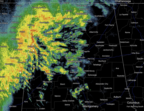
Widespread rain and some storms are ongoing across Alabama today and these will continue at times tomorrow and into Friday. The rain will be heavy at times, and the flood watch has been expanded to include the northern two-thirds of Alabama, along and north of U.S. 80, Demopolis to Montgomery, and for area in Southwest Alabama along and west of U.S. 43.

Rain amounts of 3-5 inches are likely between now and Saturday night across the state, with isolated amounts over 6 inches possible over the northern counties. There is likely to be some flooding issues in the coming days with the persistent heavy rainfall. Despite the clouds and rain, temperatures will be above average this with afternoon highs in the mid and upper 60s to low 70s
Some storms are possible, but the best chance of some strong thunderstorms will be possible across Southwest and South Alabama today and tomorrow as stronger storms there could produce strong gusty winds.
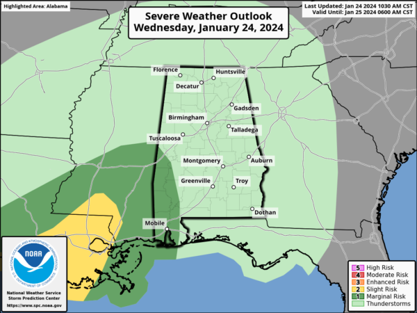
Portions of Southwest Alabama are included in a “marginal risk” (level 1/5) of severe thunderstorms later today and tonight, while much of South Alabama is in a risk area for tomorrow.
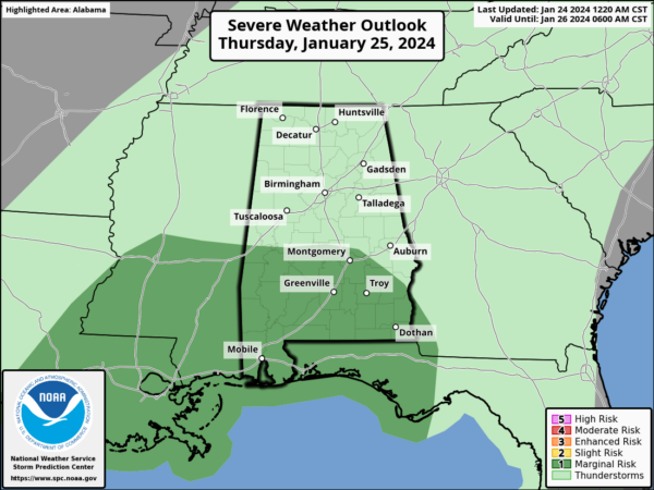
We should see a break in the rain for Friday afternoon and night before another round of rain and storms arrives on Saturday.
MORE STORMS SATURDAY: Saturday will be a mild and breezy day and another wave of energy will move across Alabama. Strong storms are possible statewide and the SPC has introduced a risk of severe storms for the eastern half of the state.
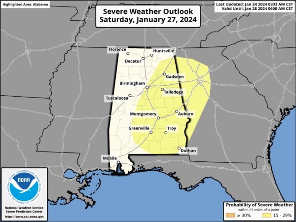
For now, damaging winds are the main concern, but we could see an increasing threat of tornadoes as well, but we still have a few days to watch this possibility. Highs Saturday will be in the low to mid 70s.
SUNDAY AND NEXT WEEK: Dry air returns to Alabama on Sunday, with a partly sunny sky along with highs in the 50s, right at seasonal levels for late January. For now much of the week the weather looks dry with highs mostly in the 50s and 60s, while lows will be in the 30s and 40s.
BEACH FORECAST CENTER: Get the latest weather and rip current forecasts for the beaches from Fort Morgan to Panama City on our Beach Forecast Center page. There, you can select the forecast of the region that you are interested in visiting.
WORLD TEMPERATURE EXTREMES: Over the last 24 hours, the highest observation outside the U.S. was 118.9F at Oodnadatta Airport, Australia. The lowest observation was -70.6F at Delyankir, Russia.
CONTIGUOUS TEMPERATURE EXTREMES: Over the last 24 hours, the highest observation was 82F at Sarasota, Tampa, Venice, and Placid, FL. The lowest observation was -17F at Presque Isle, ME.
Category: Alabama's Weather, ALL POSTS
About the Author (Author Profile)
Macon, Georgia Television Chief Meteorologist, Birmingham native, and long time Contributor on AlabamaWX. Stormchaser. I did not choose Weather, it chose Me. College Football Fanatic. @Ryan_StinnetSubscribe
If you enjoyed this article, subscribe to receive more just like it.


