Alabama Update at 3 p.m. CST: Thunderstorms Intensifying Across South Central Alabama
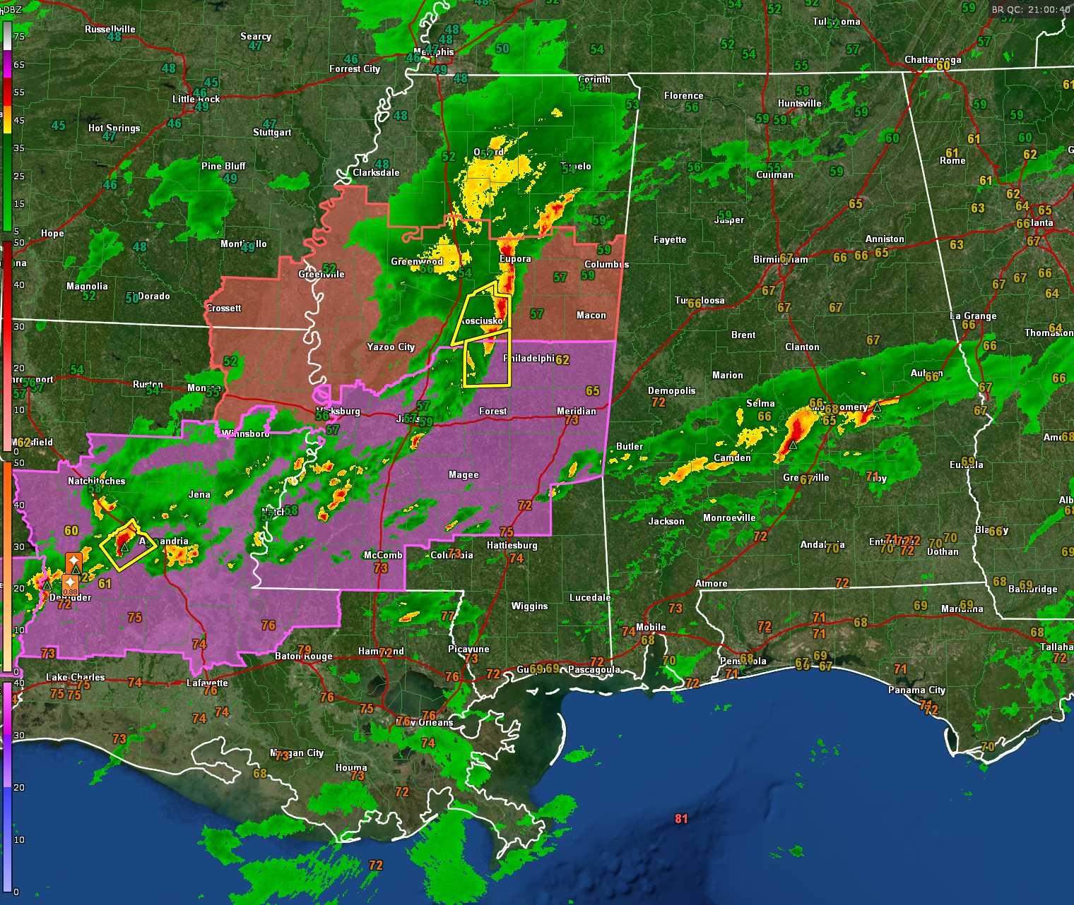
This afternoon, thunderstorms have intensified over south central Alabama, spanning from parts of southern Macon, along Highway 85 into Montgomery, Pike Road, and into southern Autauga County and Lowndes County near Hanesville and Whitehall. The storms extend back into southern Dallas County and into Wilcox and northern Clarke County.
Flood advisories were just issued for parts of Dallas, Lowndes, Autauga, and Montgomery counties where the heaviest rain is falling. A flood watch is in effect for a good bit of East Central ALabama until Monday evening. Rainfall totals will average between one and two inches across much of North and Central Alabama over the next 24 hours.
According to the National Weather Service in Mobile, one of the storms briefly reached severe levels earlier. These storms are expected to continue intensifying as they move northward into an increasingly warm and moist air mass over south central Alabama, with the potential for some storms to become severe. The Storm Prediction Center (SPC) estimates a 40% chance of issuing a severe thunderstorm watch.
Meanwhile, severe thunderstorm and tornado watches are in effect for north central and south central Mississippi. Severe thunderstorms have been reported just east of I-65 in the central part of the state near Kosciusko. In Louisiana, a tornado watch and severe thunderstorm warning are in effect for areas west of Alexandria, with reports of hail up to 1 inch in diameter.
The Storm Prediction Center has issued an enhanced risk of severe weather from central Mississippi back into central Louisiana and eastern Texas. A slight risk extends across central Alabama into western Georgia, while the rest of Alabama, except for the Tennessee Valley, is under a marginal risk for severe weather. Thunderstorms from Mississippi are expected to move into West Central Alabama later this afternoon, potentially producing damaging winds, large hail, and even a couple of tornadoes as they interact with the warm front. Stay tuned for updates as conditions evolve throughout the afternoon and evening.
Ensure you have a reliable source of weather warnings tonight and review your safety plan to know what to do if a warning is issued for your location. Stay informed with frequent updates throughout the afternoon and evening hours here on the Alabama WX weather blog.
Category: Alabama's Weather, ALL POSTS, Severe Weather
About the Author (Author Profile)
Bill Murray is the President of The Weather Factory. He is the site's official weather historian and a weekend forecaster. He also anchors the site's severe weather coverage. Bill Murray is the proud holder of National Weather Association Digital Seal #0001 @wxhistorianSubscribe
If you enjoyed this article, subscribe to receive more just like it.


