New MCD: Tornado Watch May Be Needed for Parts of Alabama This Evening
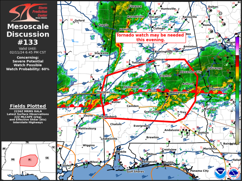
Mesoscale Discussion 0133
NWS Storm Prediction Center Norman OK
0438 PM CST Sun Feb 11 2024
Areas affected…Central Alabama
Concerning…Severe potential…Watch possible
Valid 112238Z – 120045Z
Probability of Watch Issuance…60 percent
SUMMARY…A tornado watch may be needed this evening across central
Alabama.
DISCUSSION…Low-level southerly flow has continued to destabilize
farther east across Alabama this afternoon. Additional
destabilization is expected this evening as temperatures cool aloft
ahead of the approaching mid-level trough. In addition, some
increase in low-level flow is also forecast this evening which will
elongate hodographs in the low-levels.
Thunderstorms with some supercell structures have started to mature
along and slightly north of the warm front across central
Mississippi. These storms will pose a threat for all hazards with
the greatest tornado threat associated with storms which can latch
onto or remain rooted within the more buoyant airmass south of the
warm front. There is uncertainty how likely this is, but if it does
occur, tornadoes, some potentially strong, would be possible given
the low-level shear in the region.
The evolution of these storms across Mississippi as they approach
Alabama will be monitored closely and a tornado watch may be needed
if they continue to strengthen and especially if they are able to
root along or south of the warm front.
..Bentley/Hart.. 02/11/2024
Category: Alabama's Weather, ALL POSTS, Severe Weather
About the Author (Author Profile)
Bill Murray is the President of The Weather Factory. He is the site's official weather historian and a weekend forecaster. He also anchors the site's severe weather coverage. Bill Murray is the proud holder of National Weather Association Digital Seal #0001 @wxhistorianSubscribe
If you enjoyed this article, subscribe to receive more just like it.


