Tornado Watch for South Central and South Alabama Until 9 am; Flooding Threat Exists as Well
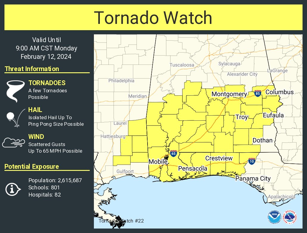
The SPC has issued a tornado watch that goes until 9 a.m. for portions of South and Central Alabama, the Florida Panhandle, and extreme southeastern Mississippi.
Here is a pretty concerning mesoscale precipitation discussion from the Weather Prediction Center.
Mesoscale Precipitation Discussion 0059
NWS Weather Prediction Center College Park MD
204 AM EST Mon Feb 12 2024
Areas affected…central Gulf Coast into the Southeast
Concerning…Heavy rainfall…Flash flooding possible
Valid 120703Z – 121303Z
Summary…Heavy rainfall related to thunderstorms increasing in
coverage across portions of the central Gulf Coast into the
Southeast could lead to hourly rain totals to 2″ with local
amounts to 4″. This would lead to isolated to widely scattered
flash flooding.
Discussion…Widespread rain with embedded scattered showers and
thunderstorms cover portions of LA, MS, AL, and GA within a broad
baroclinic leaf pattern noted on recent water vapor imagery. This
is occurring near and ahead of a surface low and its attendant
frontal boundaries, with instability noted on either side of the
slow-moving cold front in LA on SPC mesoanalyses. Inflow at 850
hPa is out of the southwest at 30-40 kts, importing 500-2000 J/kg
of MU CAPE into the region. Precipitable water values of 1.4-1.7″
lie here per recent GPS data. Cell coverage has been most
numerous generally poleward of the 4C isotherm at 700 hPa, while
activity has been more widely scattered/isolated in warmer areas
closer to the Gulf Coast thus far. Across portions of
south-central LA, there has been enough convective coverage for
short bouts of cell training overnight.
With the main upper low near the eastern OK/TX border moving
eastward, temperatures aloft (700 hPa) will cool which should
allow cell coverage to increase closer to the Gulf Coast across
southeast LA, southern MS, and portions of southern AL. The
entire heavy rain area is expected to settle slowly southeast with
time. The main heavy rain threats appear to be due to short bouts
of cell training as well as near and ahead of embedded
mesocyclones. As the cold front isn’t expected to pick up the
pace to the east until sunrise, this could allow for increased
bouts of cell training in more southern areas across LA, MS, and
AL beyond 10z. Broad warm advection will continue east of the
surface low, with heavy rainfall falling across increasingly
saturated ground across south-central MS, central AL, and central
GA. Hourly rain totals to 2″ with local amounts to 4″ are
possible, which is explicitly forecast in the mesoscale guidance
across portions of AL and GA and theoretically possible farther
southwest, given the ingredients available. This is expected to
lead to isolated to widely scattered instances of flash flooding.
Roth
Category: Alabama's Weather, ALL POSTS, Severe Weather
About the Author (Author Profile)
Bill Murray is the President of The Weather Factory. He is the site's official weather historian and a weekend forecaster. He also anchors the site's severe weather coverage. Bill Murray is the proud holder of National Weather Association Digital Seal #0001 @wxhistorianSubscribe
If you enjoyed this article, subscribe to receive more just like it.


