Midday Nowcast: Radar Remains Active
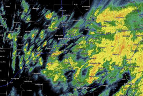
The radar remains active with rain and storms ongoing across much of Alabama today. The flood watch continue through the afternoon hours, and the severe weather threat if moving off towards the east. Late this afternoon, some partial clearing is possible. However, a narrow band of showers will likely develop along a cold front. Any additional rain this evening will be light, and the showers should be out of the state by midnight. Temperatures today are in the 60s.
USA BRIEF: A significant winter storm from the Mid-South today will transition to a strong Nor’easter for the Mid-Atlantic and New England by Tuesday. Severe thunderstorms, heavy rainfall, and flash flooding will be possible across portions of the Southeast today. A new storm system arrives across the Pacific Northwest by the middle of the week with areas of locally heavy rain and mountain snowfall.
REST OF THE WEEK: Tomorrow will be sunny and cooler with a high in the 50s for most communities. A much needed day to dry out for all of Alabama. The dry weather continues Wednesday and Thursday with highs back in the 60s. Then, we will bring in a chance of rain late Friday and Friday night ahead of a cold front. Moisture will be limited, and rain amounts should be 1/2 inch or less. No risk of severe storms.
WEEKEND WEATHER: Rain will end Saturday morning for most of the state, although lingering showers are possible during the afternoon and evening hours near the Gulf Coast. The day will be cooler with a high in the 50s. Then, on Sunday, we expect sunshine in full supply with highs remaining in the 50s. Dry weather continues into the first of the following week with a warming trend. Still no sign of any bitterly cold Arctic air for Alabama and the Deep South.
BEACH FORECAST CENTER: Get the latest weather and rip current forecasts for the beaches from Fort Morgan to Panama City on our Beach Forecast Center page. There, you can select the forecast of the region that you are interested in visiting.
WORLD TEMPERATURE EXTREMES: Over the last 24 hours, the highest observation outside the U.S. was 115.5F at Marble Bar, Australia. The lowest observation was -65.0F at Vostok, Antarctica.
CONTIGUOUS TEMPERATURE EXTREMES: Over the last 24 hours, the highest observation was 88F at Plant City, FL. The lowest observation was -12F at Angel Fire, NM.
Category: Alabama's Weather, ALL POSTS
About the Author (Author Profile)
Macon, Georgia Television Chief Meteorologist, Birmingham native, and long time Contributor on AlabamaWX. Stormchaser. I did not choose Weather, it chose Me. College Football Fanatic. @Ryan_StinnetSubscribe
If you enjoyed this article, subscribe to receive more just like it.


