Big Warm Up Ahead
Sunday, February 25, 2024
Forecaster: Bill Murray
***NO VIDEO THIS MORNING DUE TO TRAVEL***
As we wake up on this Sunday morning, Central Alabama is experiencing clear skies following the passage of a secondary cold front last night. Overnight, we’ve seen northwest to north winds, although they’re gradually tapering down from the gustier conditions we felt yesterday. Temperatures have dropped, with some areas in the northeast portion of the region dipping below freezing, while other parts are starting the day in the mid to upper 30s. Yesterday afternoon, we witnessed the passage of the secondary cold front, driven by a shortwave trough moving across the Ohio Valley towards the East Coast. Despite the front’s movement, no precipitation occurred, and we enjoyed plenty of sunshine with temperatures running slightly warmer than expected, thanks to the northwesterly flow. High temperatures ranged from the lower 60s in the north to the lower 70s in the south, though the brisk winds made it feel cooler, especially in shaded spots.
FOR YOUR SUNDAY: Looking ahead to today, ridging will become more dominant over our area, leading to gradual height rises in the atmosphere. Surface winds will shift to a more northeasterly direction as the morning progresses, and we can expect clear skies with some passing mid-level clouds. Temperatures are expected to remain relatively cool overnight, with a gradual warming trend during the day. Highs today will reach into the mid-70s in the southwest and mid-60s in the northeast.
THE WEEK AHEAD: As we head into the upcoming week, expect minor changes in temperatures through mid-week, with zonal flow aloft and moderating conditions pushing highs into the mid-70s to lower 80s by Tuesday. Towards the middle of the week, a weather system approaches, with a chance of showers and thunderstorms as a cold front moves through the region. By Wednesday, we anticipate the passage of a cold front, accompanied by a band of showers and a few embedded thunderstorms. While severe weather isn’t expected at this time, we’ll keep an eye on any developments. Behind the front, cooler air will filter into the area, leading to a more refreshing end to the week.
WEEKEND OUTLOOK: A few showers will be hanging around mainly over South Alabama by Friday, and a couple of stray showers could impact us on Saturday.
FIRE WEATHER: Fire weather conditions remain a concern, with relative humidities dropping into the 20-25 percent range south of I-20 this afternoon. Moisture levels will gradually increase as we move through the week, with rain chances returning by mid-week.
BEACHCAST: For beach enthusiasts in Alabama and Northwest Florida, the remainder of the weekend into the early week promises sunny skies with temperatures climbing to the upper 60s. Sunday sees a low rip current risk and surf heights at a manageable 1 to 2 feet, ideal for beach activities. Moving into Monday and Tuesday, expect continued sunny conditions with temperatures in the upper 60s, but be aware of increasing surf heights up to 3 to 5 feet by Tuesday, signaling a high rip current risk.
Click here to see the Beach Forecast Center page.
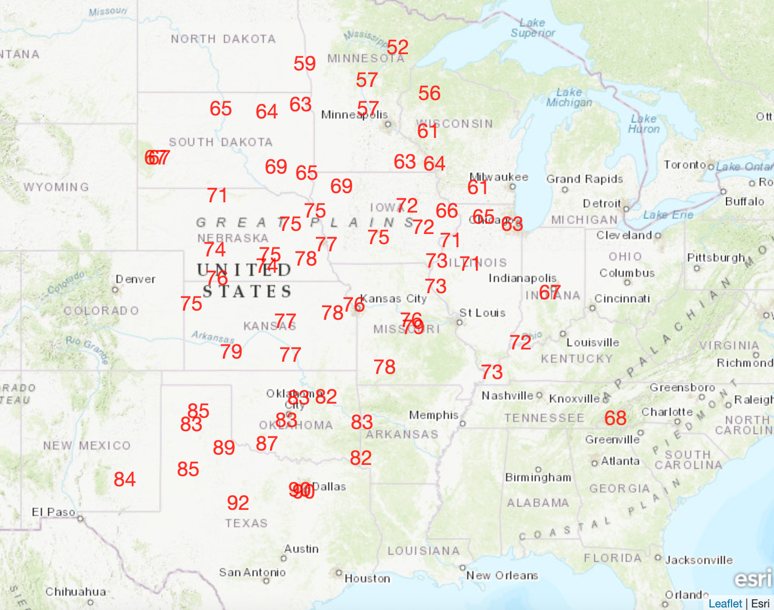
NATIONAL HIGHLIGHTS: Record warmth is expected across the Plains states early this week. Multiple cities are forecast to reach or exceed their record highs for Monday. Some areas in the Southwest may approach the 90 degree mark. Here are forecast record highs for Monday:
ADVERTISE WITH US: Deliver your message to a highly engaged audience by advertising on the AlabamaWX.com website. We have a lot of big plans for this year. Don’t miss out! We can customize a creative, flexible, and affordable package that will suit your organization’s needs. Contact me, Bill Murray, at (205) 687-0782 and let’s talk.
WEATHERBRAINS: This week, the panel will entertain one of our most famous guests ever, Tom Grazulis of the Tornado Project. He has written and maintained the definitive collection of records of significant tornadoes ever to hit the United States. He will tell his story Monday night at 7 p.m. Check out the show at www.WeatherBrains.com. You can also subscribe on iTunes. You can watch the show live on our new YouTube channel for the show.You will be able to see the show on the James Spann 24×7 weather channel on cable or directly over the air on the dot 2 feed.
ON THIS DATE IN 1934: A significant tornado outbreak impacted Mississippi, Alabama, and Georgia. The first Alabama tornado touched down around 4 p.m. in Calera, where it destroyed four adjacent homes. It went on to hit the eastern part of Columbiana, also in Shelby County. One person was killed and 12 were injured. The next significant tornado sizzled out of the sky in Clay County near Millerville and followed a 15 mile path to 3 miles south of Ashland. Four people died along the path and 40 were injured. The hardest hit area was Shady Grove. The final significant tornado of the day in Alabama occurred around 5 p.m. in Randolph County. It would cut a path all the way into Carroll County, Georgia, where it would strike Bowden College. The tornado destroyed the main campus building’s roof and a dormitory, and a house northeast of Bowden was destroyed, killing a husband and wife. The storm also caused roofing sheets to be thrown over treetops and wrapped around telephone poles, and chimneys to be blown down. Another thirty people were injured by this tornado. Follow my weather history tweets on Twitter. I am @wxhistorian at Twitter.com.
Category: Alabama's Weather, ALL POSTS, Severe Weather
About the Author (Author Profile)
Bill Murray is the President of The Weather Factory. He is the site's official weather historian and a weekend forecaster. He also anchors the site's severe weather coverage. Bill Murray is the proud holder of National Weather Association Digital Seal #0001 @wxhistorianSubscribe
If you enjoyed this article, subscribe to receive more just like it.


