Strong Storms Entering West Alabama at this Hour
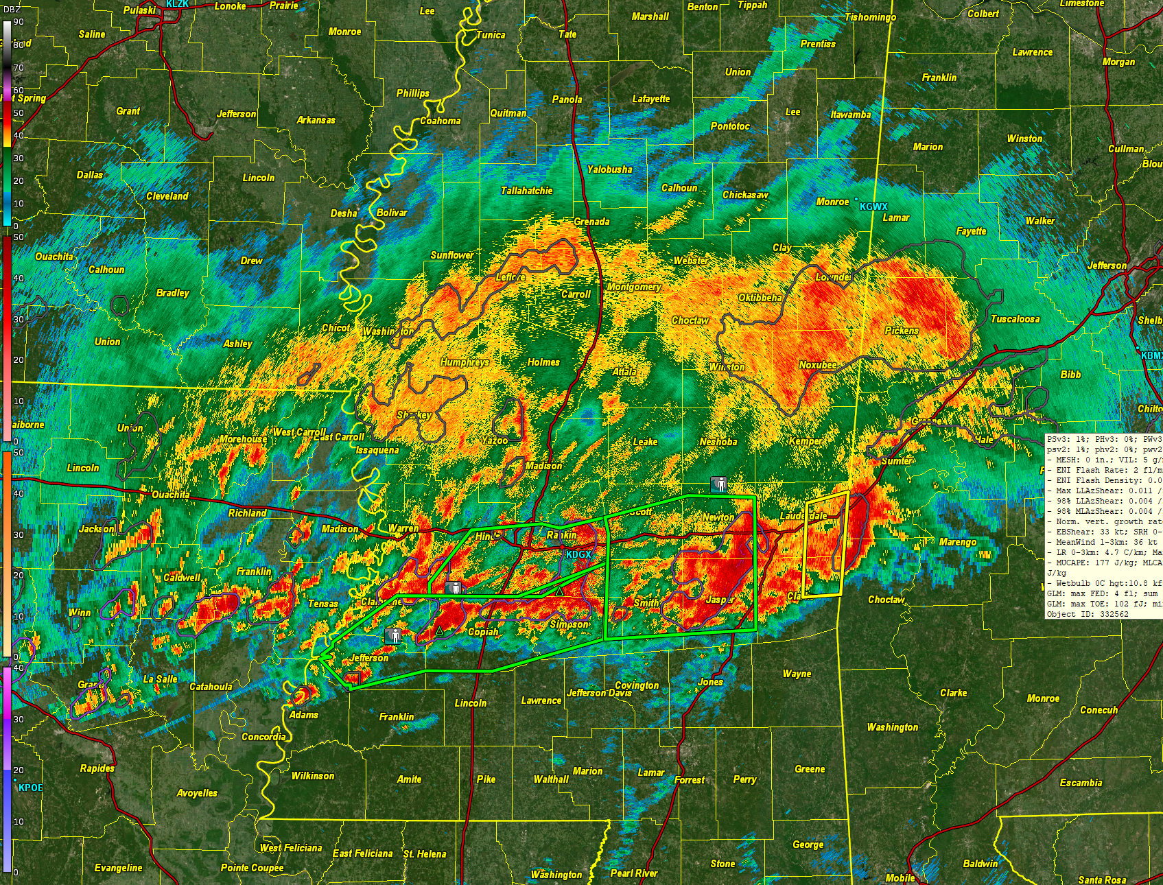
A look from the Jackson MS WSR-88D radar at12:30 pm
Flash flood concern is increasing across Central and South Alabama for this afternoon through Saturday. Severe weather is possible across South Central and South Alabama.
Strong thunderstorms coming out of Clarke and Lauderdale Counties in Mississippi are about to move into southern Sumter and northern Choctaw Counties in West Alabama.
The storms are the leading edge of an elongated mesoscale convective system that is moving eastward over Central Mississippi. The east-west orientation of these storms means that many areas will pick up repeated bouts of rain and storms, like train cars traveling down a track. Rainfall rates will reach 2 inches per hour in some cases and could reach five inches through late afternoon. This will exceed flash flood guidance values and result in some flash flooding. Some of could be serious.
Numerous flash flood warnings are in effect across Central Mississippi.
Rainfall across Central Alabama will be in the 205 inch category with some 8 inch amounts possible especially near and north of I-85.
The storms are moving into less unstable air and are weakening a bit, so severe weather is not expected at this time. Lightning rates in the lead storm have really dropped. But as the airmass to the south of the storms continues to warm and moisten over the next few hours, we can’t rule out the possibility of severe weather including the threat of tornadoes later in areas along and south of the rain cooled boundary that will set up across South Central Alabama.
The weather situation across the south right now includes a strong upper level trough axis moving across Arizona and New Mexico this afternoon. A fast flow in the mid and lower levels of the atmosphere is transporting a very moist airmass into the region.
Precipitable water values are is in the 1.7-1.9 inch range, which is near all time highs for the month of March for Central Alabama and Central Mississippi. Favorable conditions aloft are making for efficient rainmaking.
There is a slight risk of severe storms (level 2 out of 5) for the southern half of Central Alabama through about 9 a.m. Saturday. Damaging wind gusts of 60 mph and a few tornadoes are possible.
The best chances for severe weather will be between 6 pm and 1 am tonight over West Central Alabama, between 9 pm and 5 am in the I-65 Corridor, and after midnight in East Central Alabama. The threat should be over by 9 a.m.
It will be breezy today and this evening with winds of 12-18 mph gusting to over 30 mph at times through midnight tonight. The winds will be out of the east and southeast.
Cooler and drier air will move in behind the cold front, with quiet conditions Saturday night through Wednesday.
Potential frost development will occur Sunday night and Monday night, with some areas dropping below freezing Monday morning.
Stay tuned for frequent updates through the afternoon and overnight.
Category: Alabama's Weather, ALL POSTS, Severe Weather
About the Author (Author Profile)
Bill Murray is the President of The Weather Factory. He is the site's official weather historian and a weekend forecaster. He also anchors the site's severe weather coverage. Bill Murray is the proud holder of National Weather Association Digital Seal #0001 @wxhistorianSubscribe
If you enjoyed this article, subscribe to receive more just like it.


