Saturday Morning Briefing — Improving Today with Cooler Temperatures
*** Sorry for the late posting and the lack of a video. I will post a video later this morning after fixing computer issues. ***
THIS WEEKEND:
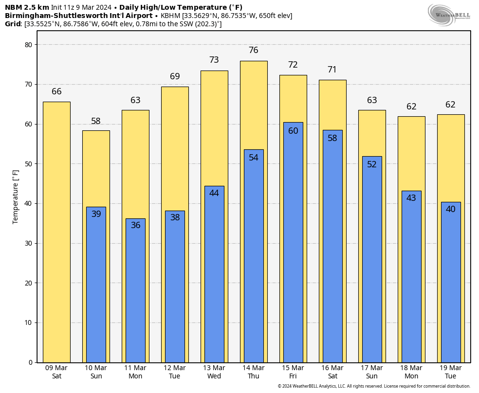
A surface low is progressing eastward across far southeast Central Alabama. An initial shortwave and low-level jetstream are ushering thunderstorms and heavy rainfall into Georgia, while a mid-level trough poised to traverse the Tennessee Valley. Northern counties can anticipate light rain and/or drizzle through the morning as a cold front approaches, ushering in breezy northwesterly winds and gradually clearing skies. Temperatures will vary significantly, with highs in the mid 50s in the northwest and near 70 in the southeast before the front’s passage, with most areas reaching their peak temperatures around midday.
Tonight and Sunday, cooler and drier conditions will prevail as cooler air settles over the region and surface high pressure holds sway to the west. Winds will remain elevated tonight, with lows ranging from the mid 30s to mid 40s. Sunday will bring sunny skies with highs in the mid 50s to lower 60s.
NEXT WEEK:
By Sunday night, the longwave trough will shift towards the East Coast, allowing broad ridging to establish across much of the CONUS. Surface high pressure will dominate near the region on Sunday and Monday nights, resulting in light winds and temperatures dipping into the 30s. Frost and freezing temperatures will be possible each night. As we head into Tuesday, the airmass will gradually moderate as the surface high shifts off the East Coast and troughing intensifies across the western US. Southerly to southwesterly flow will lead to a rebound in temperatures and moisture through midweek, with passing shortwaves contributing to increased cloud cover but having minimal impact on local weather conditions.
Towards the end of the week, a shortwave and associated surface low will progress towards the Great Lakes from the Central Plains, dragging a cold front towards the Southeast by Friday/Saturday. However, there are discrepancies in model guidance regarding the timing and extent of the front’s movement. As of now, another wet end to the workweek can be expected, but specific details may change as we approach the timeframe.
Category: Alabama's Weather, ALL POSTS, Weather Xtreme Videos
About the Author (Author Profile)
Scott Martin is an operational meteorologist, professional graphic artist, musician, husband, and father. Not only is Scott a member of the National Weather Association, but he is also the Central Alabama Chapter of the NWA president. Scott is also the co-founder of Racecast Weather, which provides forecasts for many racing series across the USA. He also supplies forecasts for the BassMaster Elite Series events including the BassMaster Classic.Subscribe
If you enjoyed this article, subscribe to receive more just like it.


