Midday Nowcast: Sunny, Warmer Days
TERRIFIC TUESDAY: Plenty of sunshine in the Alabama sky today and temperatures are warming up nicely this afternoon with upper 60s and lower 70s. Tonight, will be cold, but not as cold as it has been, we should lows in the lower 40s.
USA BRIEF: A strong Pacific storm will move ashore with strong winds, heavy mountain snows and lower elevation rain through mid-week. This storm is forecast to strengthen across the central Plains with heavy snow for the central Rockies, severe weather for portions of the Missouri Valley. Meanwhile, well above normal temperatures for most of the east. Dry conditions for the Plains may spread fires quickly.
WEDNESDAY/THURSDAY: The warming trend continues tomorrow and Thursday with more sun than clouds we will see highs in the mid to upper 70s tomorrow, followed by upper 70s and lower 80s on Thursday. Clouds will begin to increase late Thursday, with rain returning to Alabama Thursday night. A few showers may be possible across West Alabama during the afternoon.
FRIDAY & THE WEEKEND: Rain and thunderstorms are in the forecast for statewide Friday. A few strong storms are possible Friday, but for now the severe weather threat remains low due to lack of forcing. The unsettled weather will continue into the weekend. We will deal with showers on Saturday, followed by more widespread rain and storms on Sunday. It certainly won’t rain all weekend, and the sun might peek out at times Saturday, but know there will be rain possible at anytime both days.
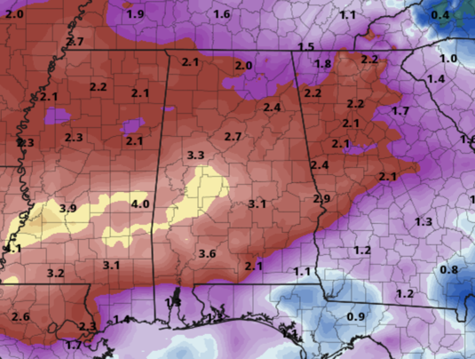
Rain totals Friday through Sunday night will be in the 2-3 inch range for most of Alabama, and some flooding issues are certainly possible. Highs will be in the 70s Friday and Saturday, followed by 60s Sunday.
ANOTHER COLD SNAP: Rain on Monday will be most likely confined to far South Alabama as a cold front pushes through the state. Tuesday will be noticeably colder and another late season freeze looks likely by Tuesday morning with lows in the 25-35 degree range over the northern half of the state. Tuesday highs look to hold in the 50s. Temperatures begin to moderate through the week and rain will likely return by either Thursday or Friday.
BEACH FORECAST CENTER: Get the latest weather and rip current forecasts for the beaches from Fort Morgan to Panama City on our Beach Forecast Center page. There, you can select the forecast of the region that you are interested in visiting.
WORLD TEMPERATURE EXTREMES: Over the last 24 hours, the highest observation outside the U.S. was 117.0F at Vioolsdrif, South Africa. The lowest observation was -85.4F at Vostok, Antarctica.
CONTIGUOUS TEMPERATURE EXTREMES: Over the last 24 hours, the highest observation was 84F at Rio Grande Village, TX. The lowest observation was -6F at Peter Sinks, UT.
Category: Alabama's Weather, ALL POSTS
About the Author (Author Profile)
Macon, Georgia Television Chief Meteorologist, Birmingham native, and long time Contributor on AlabamaWX. Stormchaser. I did not choose Weather, it chose Me. College Football Fanatic. @Ryan_StinnetSubscribe
If you enjoyed this article, subscribe to receive more just like it.


