Midday Nowcast: Sunny and Warmer First Full Day of Spring
WELCOME TO SPRING: Today is the first official full day of spring as the vernal equinox occurred at 10:06 PM CDT last night. Today started out cold, but with sunny sky we are seeing afternoon highs surging into the low 70s for many North/Central Alabama communities. Tonight will be a chilly one, but not as cold as recent nights, lows tonight will be in the low to mid 40s.
ACROSS THE USA: A cold front continues to produce lake-effect snow downwind of Lake Ontario and snow will spread across portions of the Interior Northeast and New England through Thursday. Strong, gusty winds and dry air may produce elevated fire weather conditions across portions of the Mid-Atlantic and the Southern Plains today.
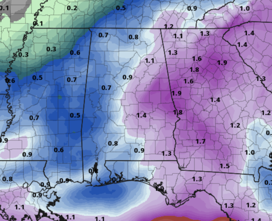
TOMORROW/FRIDAY: Clouds will increase late tomorrow and the day will be dry, but rain returns tomorrow night and is likely throughout the day on Friday a low pressure tracks along the Gulf Coast. With the low to the south of us, there is no threat of severe weather and likely very little thunder. Rain amounts should be in the 1/2-1 inch range.
Highs tomorrow will be in the 70s, while Friday will feature highs in the low to mid 60s.
THE ALABAMA WEEKEND: The low is slowing down and we will have to keep clouds in the forecast for Saturday with some showers possible across portions of East Alabama due to wrap around moisture on the back side of the low. Highs Saturday will be in the low to mid 60s. Dry air finally returns Sunday and we are expecting a sunny sky with highs in the low 70s.
NEXT WEEK: Monday will be dry with a high in the low to mid 70s, then rain and storms return to the state Tuesday. Some strong storms are possible but for now, it doesn’t look like a severe weather setup for the state due to lack of surface based instability. This could change in the coming day and we will keep an eye on model trends through the weekend. Wednesday looks dry, but a few showers looks possible Thursday. Highs most of next week will be in the 70s.
EASTER WEEKEND SNEAK PEEK: Very low confidence in the forecast for now as we are 10-12 days out and there remains model inconsistencies, but current trends suggest some rain on Friday or Saturday with another possible late season cold snap for Easter weekend.
BEACH FORECAST CENTER: Get the latest weather and rip current forecasts for the beaches from Fort Morgan to Panama City on our Beach Forecast Center page. There, you can select the forecast of the region that you are interested in visiting.
WORLD TEMPERATURE EXTREMES: Over the last 24 hours, the highest observation outside the U.S. was 113.2F at Vioolsdrif, South Africa. The lowest observation was -83.4F at Concordia, Antarctica.
CONTIGUOUS TEMPERATURE EXTREMES: Over the last 24 hours, the highest observation was 87F at Death Valley, CA. The lowest observation was -3F at Peter Sinks, UT.
Category: Alabama's Weather, ALL POSTS
About the Author (Author Profile)
Macon, Georgia Television Chief Meteorologist, Birmingham native, and long time Contributor on AlabamaWX. Stormchaser. I did not choose Weather, it chose Me. College Football Fanatic. @Ryan_StinnetSubscribe
If you enjoyed this article, subscribe to receive more just like it.


