The Sunday Briefing — Very Nice Today; A Windy & Wet Start to the Work Week
Today, we have a nice day ahead, with clear skies and temperatures warming up to the mid 60s to lower 70s in Central Alabama. We’ll have light northerly winds in the morning, which will turn easterly and then southeasterly in the afternoon. However, tonight, the winds will become gusty as the pressure gradients increase, indicating some changes are on the way.
As we move into Monday, a low-pressure system will deepen near the Rocky Mountains and head southeast, bringing more moisture and increasing clouds to our area. By Monday afternoon, we might start feeling strong winds, especially in the western parts of our region. These gusty winds are expected to continue into Tuesday morning. Wind advisories have been issued for much of the area starting on Monday afternoon and stretching into Tuesday morning.
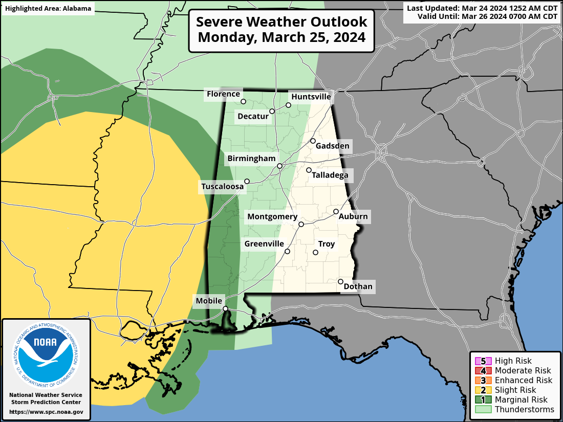
Monday night into Tuesday morning, we’re expecting a line of showers and thunderstorms to move in, mainly affecting areas west of I-65. This could bring locally heavy rainfall, possibly causing flooding in some areas. While severe weather threats are low, we might see some strong non-thunderstorm winds, gusting up to 35-45 mph.
The rain and storms should taper off by Tuesday afternoon as the system moves eastward, bringing cooler and drier air with clearing skies for the rest of the week. Temperatures will be quite comfortable, ranging from the lower 60s to the lower 80s throughout the week, with a noticeable warming trend toward the weekend.
Wednesday through Sunday is shaping up to be a stable and pleasant period for Central Alabama. A broad trough in the upper levels of the atmosphere will be positioned across the central part of the country, while flow aloft will be southwestward toward the East Coast. This setup will bring stable conditions to our region, ensuring calm weather with no significant disturbances expected.
On Wednesday, we can anticipate highs ranging from the lower 60s to the mid 70s. The day will likely be characterized by clear skies and comfortable temperatures, making it a great time to enjoy outdoor activities or simply soak in the sunshine.
As we move into Thursday, temperatures will remain similar, with highs in the mid 60s to the lower 70s. The weather pattern will continue to be stable, with no major changes expected in terms of cloud cover or precipitation.
By Friday, a noticeable warming trend will begin to take shape. Highs are expected to reach the upper 60s to the mid 70s, signaling a gradual increase in temperatures as we head into the weekend.
The weekend itself looks quite promising, with Saturday and Sunday bringing even warmer conditions. Highs on Saturday are forecasted to be in the mid 70s to the lower 80s, offering perfect weather for outdoor activities, picnics, or enjoying nature.
Sunday will follow a similar trend, with highs ranging from the mid 70s to the lower 80s. This continued warming trend will be accompanied by mostly clear skies, making it an ideal time to spend time outdoors with family and friends.
Category: Alabama's Weather, ALL POSTS, Severe Weather, Weather Xtreme Videos
About the Author (Author Profile)
Scott Martin is an operational meteorologist, professional graphic artist, musician, husband, and father. Not only is Scott a member of the National Weather Association, but he is also the Central Alabama Chapter of the NWA president. Scott is also the co-founder of Racecast Weather, which provides forecasts for many racing series across the USA. He also supplies forecasts for the BassMaster Elite Series events including the BassMaster Classic.Subscribe
If you enjoyed this article, subscribe to receive more just like it.


