

Windy, Wet Night Ahead For Alabama; Dry, Warm Easter Weekend
BREEZY AFTERNOON: Clouds are increasing across Alabama this afternoon with a mostly cloudy sky. Nothing on radar at mid afternoon.
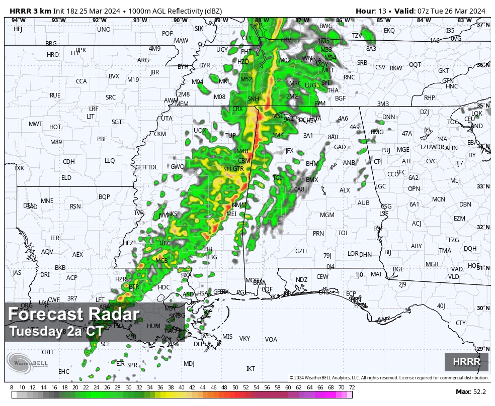
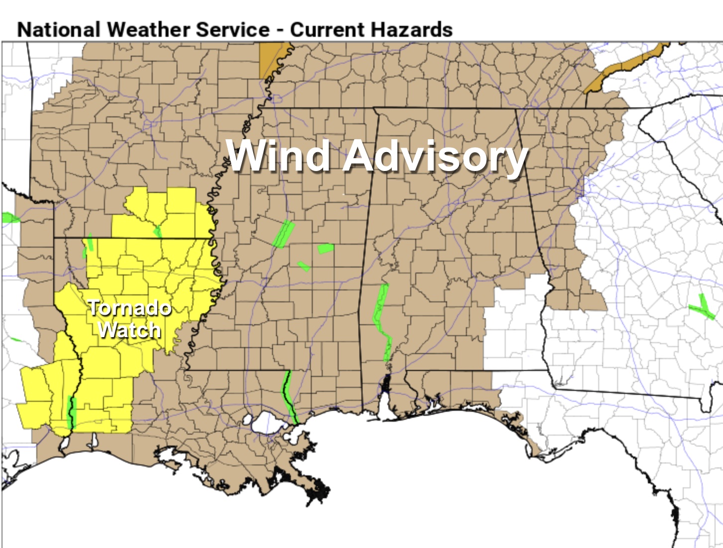
TONIGHT: A band of showers and thunderstorms will push into Alabama late tonight, mostly after midnight. Thankfully there will be little to no surface based instability available over the northern 2/3 of the state, so the line of storms will be weakening, and the threat of severe storms remains low in our state. The air will be somewhat unstable over Southwest Alabama, but the main dynamic support will be lifting away from that area. Still, a few storms over Southwest Alabama could produce strong, gusty winds. It is very clear the main risk of severe storms will be west of Alabama late today and tonight over parts of Arkansas, Louisiana, and Mississippi.
GRADIENT WIND: The main concern tonight is gradient winds, not related to thunderstorms. Winds tonight will average 15-30 mph, with potential for gusts to 40/45 mph in spots. Be sure and secure any loose objects on your property, and know there could be a few scattered power outages tonight. Winds will diminish after the thunderstorm line passes after midnight.
RAIN: Rain amounts will average 1-2 inches for most of Alabama over the next 36 hours; parts of West Alabama could see over 2 inches. A few isolated flooding issues are possible. Most of the rain will come from around midnight tonight through noon tomorrow.
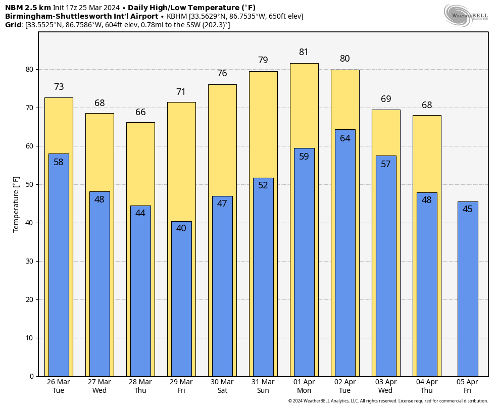
Some clearing is possible tomorrow afternoon as dry air works into the Deep South; the high tomorrow will be in the low to mid 70s in most places.
REST OF THE WEEK: While a lingering shower can’t be totally ruled out across the southeast corner of the state tomorrow night and Wednesday, the rest of the state will be dry with cool mornings and pleasant afternoons. Highs will be in the 65-72 degree range; colder spots across North Alabama could see lows in the mid to upper 30s early Friday morning.
EASTER WEEKEND: The weather looks dry and warmer. The high Saturday will be well into the 70s, with potential for 80 degree warm Sunday for much of Alabama. Expect partly to mostly sunny days and fair nights.
The first half of next week looks dry; global models aer advertising the next chance of rain by late Wednesday or Thursday. See the video briefing for maps, graphics, and more details.
ON THIS DATE IN 2021: Eleven tornadoes touched down across Alabama; some of them were long track. The most stunning tornado of the event was the long track EF-3 tornado that carved a path of damage spanning 80.38 miles over its 98 minute lifespan from Hale to Shelby Counties. This was a single tornado, putting it at #7 for the longest single tornado track in the state of Alabama.
Six people were killed by an EF-3 tornado that was down for 38 miles through parts of Calhoun and Cherokee counties. Another EF-3 tornado touched down near West Blocton, and then moved through some highly populated neighborhoods in north Shelby County. Damage was severe in neighborhoods like Eagle Point, Greystone Farms, and Shoal Creek. This tornado was down for 50 miles, and there were five injuries.
Look for the next video briefing here by 6:00 a.m. tomorrow…
Category: Alabama's Weather, ALL POSTS, Weather Xtreme Videos
About the Author (Author Profile)
James Spann is one of the most recognized and trusted television meteorologists in the industry. He holds the AMS CCM designation and television seals from the AMS and NWA. He is a past winner of the Broadcast Meteorologist of the Year from both professional organizations.Subscribe
If you enjoyed this article, subscribe to receive more just like it.


