Severe Weather Alert: A Potent Storm System Targets Alabama
As Alabama basks in the brief respite of sunshine and unseasonably warm temperatures reaching into the low to mid-80s, residents are advised to stay vigilant for a severe weather threat tomorrow. The looming threat of severe weather is expected to unfold starting Tuesday afternoon through the early hours of Wednesday. The heart of the concern lies in a developing system off to our west, marked by an upper trough that will dig southward into the southern plains, propelling toward the lower Mississippi Valley.
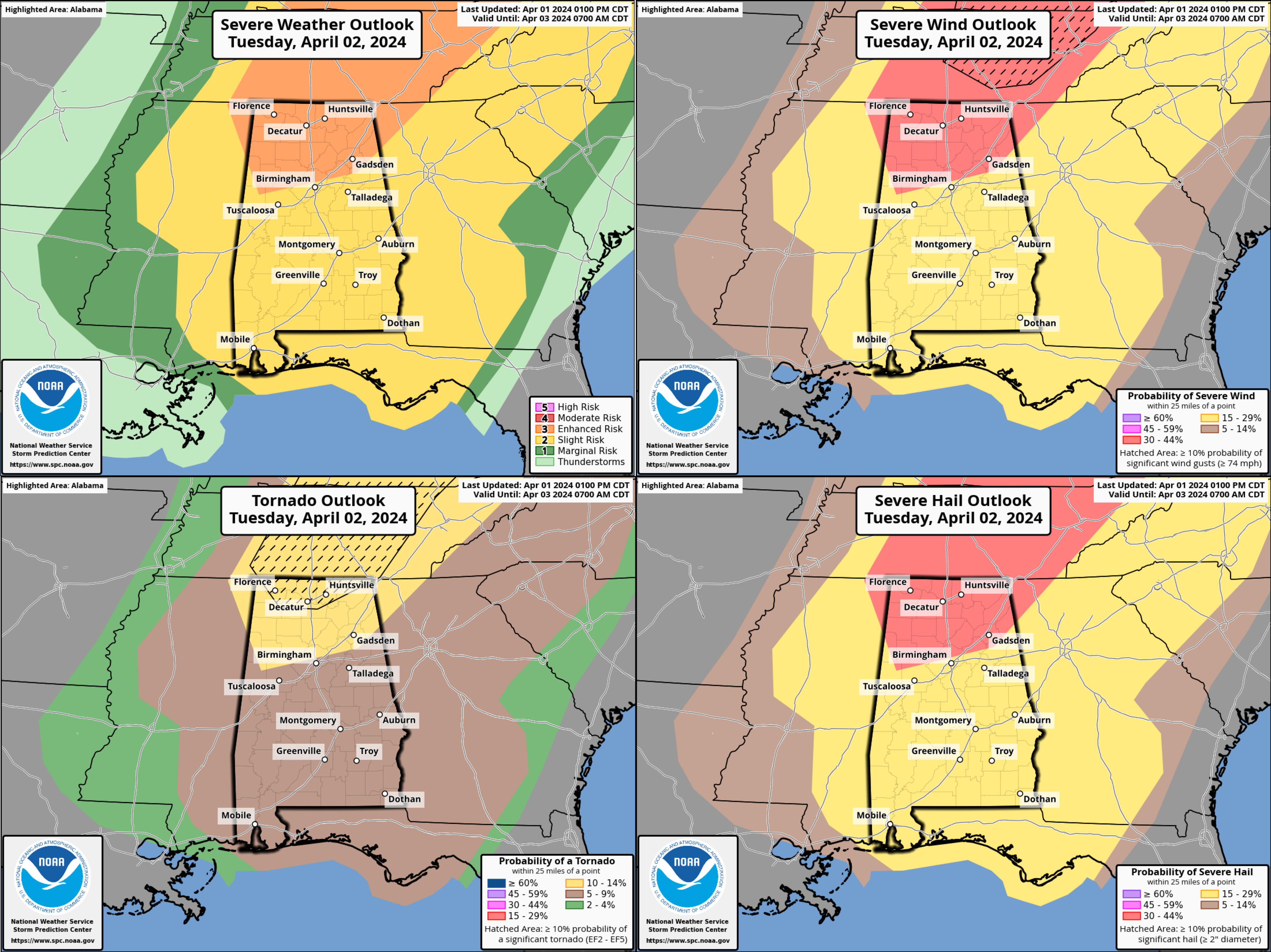
Tuesday’s weather scenario sets the stage with a broken line of showers and storms anticipated to form ahead of an approaching cold front. The synergy of a deepening surface low and high pressure off the Florida coast will ramp up southerly winds to 15-25 mph, with gusts up to 30 mph possible. This setup will contribute to a moderately unstable environment by Tuesday afternoon, increasing the risk for severe weather, including damaging winds and large hail, across northern Alabama and southern middle Tennessee.
This initial wave could bring hail and wind threats, particularly to our Tennessee Valley counties, as well as Lamar, Marion, and Winston Counties between 3 pm and 5 pm, with a few tornadoes also in the realm of possibility. This system, driven by effective shear of 60 to 70 knots and SBCAPE of 1000-1500 J/kg, poses a significant risk as it advances into northwestern Alabama.
Moving into Tuesday evening, the threat escalates with a line of thunderstorms marching into Central Alabama from the northwest. This event will likely carry through to the late night, fueled by ample instability and deep-layer shear conducive to strong to severe storms. The primary concerns are damaging winds and hail, although the potential for tornadoes cannot be overlooked. This severe weather episode is tied closely to a more southerly flow ahead of the cold front, enhancing the low-level directional shear.
The Storm Prediction Center has upgraded the Day Two Severe Weather Outlook for Alabama and areas to the north, indicating a moderate risk across Ohio and into parts of southeastern Indiana, northern Kentucky, and western West Virginia. This broad swath of the country is on alert for a severe weather outbreak that could include significant, long-track tornadoes, with the highest probabilities centered over Ohio and stretching southward across the Tennessee Valley.
Residents across Alabama and the broader are urged to monitor updates closely and prepare for the incoming severe weather. Safety measures should be reviewed, and emergency plans in place to navigate the potential impacts of this significant storm system. Stay informed, stay prepared, and most importantly, stay safe as we face the unfolding weather challenges together.
Post-storm, Central Alabama can expect a shift toward cooler, drier conditions from Wednesday through Friday. Morning lows are forecast to drop into the 40s and mid-30s, introducing a likelihood of frost, particularly in northern counties.
Category: Alabama's Weather, ALL POSTS, Severe Weather
About the Author (Author Profile)
Bill Murray is the President of The Weather Factory. He is the site's official weather historian and a weekend forecaster. He also anchors the site's severe weather coverage. Bill Murray is the proud holder of National Weather Association Digital Seal #0001 @wxhistorianSubscribe
If you enjoyed this article, subscribe to receive more just like it.


