Midday Nowcast: Warm and Cloudy Monday; Strong Storms Late Tomorrow
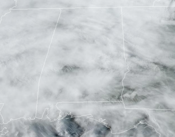
WELCOME TO APRIL: The new month starts off the way the last one ended, dry and very warm. Today we are seeing temperatures surge into the 80s for most locations despite more clouds than sun in the sky. Tonight will be mainly cloudy with lows in the mid to upper 60s.
USA BRIEF: A strengthening storm system will track from the southern Plains to New England this week with widespread hazardous weather. Severe thunderstorms and excessive rainfall possible from the Plains to the Ohio and Tennessee River Valleys. Dry, gusty winds bringing critical fire weather to the southern High Plains. Heavy snow and high winds possible over high elevations of New England later this week.
STORMS RETURN TOMORROW: The weather becomes active late tomorrow and tomorrow night as an organized band of showers and thunderstorms moves into the Deep South ahead of a cold front. The Storm Prediction Center has defined an “enhanced risk” (level 3/5) of severe thunderstorms for the Tennessee Valley of North Alabama; a “slight risk” (level 2/5) extends as far south as Demopolis, Clanton, and Ranburne. For South Alabama, a “marginal risk” (level 1/5) is in place.
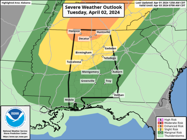
Most of tomorrow will be fine, but late tomorrow afternoon strong storms will roll into the state. For now, the main window for storms will come from 4PM through 2AM Wednesday. The main threat for Alabama will come from strong, potentially damaging straight line winds. The main parameters needed for tornadoes will be to the north, mainly across the Ohio River Valley, but an isolated tornado or two can’t be ruled out across North Alabama tomorrow night. Some hail is possible as well.
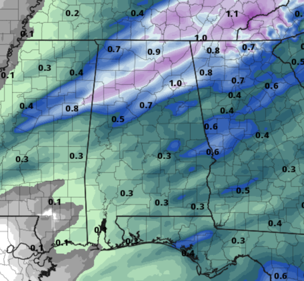
Rain amounts will be in the 1/2 to 1 inch for the northern half of Alabama, and under 1/2 inch for the southern counties of the state. Certainly enough to wash away the current coating of pollen on everything.
MUCH COOLER REST OF WEEK: Wednesday will be breezy and much cooler with highs in the upper 50s to lower 60s with lingering clouds.Thursday and Friday will be sunny and cool statewide with a high in the 60s, which are below average for the first week of April as average high for Birmingham is 72°.
GROWERS BEWARE: We have the potential for frost over the northern 2/3 of Alabama Friday, and possibly Saturday morning. Colder spots could see a freeze. Growers will need to monitor temperature forecasts and may need to protect sensitive vegetation. Just a point of reference, over the last 30 years, the average last freeze for Birmingham occurs on March 25th. However, during this time frame, the latest last freeze to occur was April 22, 1993. Again, we always say it is best not to plant anything before Tax Day (April 15th) just to be safe.
THE WEEKEND: Dry weather continues over the weekend with lots of sun. Temperatures will begin to moderate as well, as highs looks to return to the 70s. Next chance of showers will be at some point around the middle part of the next week.
ECLIPSE WEATHER: We are a week away from the eclipse when Alabama will experience a partial solar eclipse next Monday April 8th. For now we are forecasting a partly sunny sky, with temperatures near 70°.
BEACH FORECAST CENTER: Get the latest weather and rip current forecasts for the beaches from Fort Morgan to Panama City on our Beach Forecast Center page. There, you can select the forecast of the region that you are interested in visiting.
WORLD TEMPERATURE EXTREMES: Over the last 24 hours, the highest observation outside the U.S. was 115.2F at Ndjamena, Chad. The lowest observation was -98.0F at Concordia, Antarctica.
CONTIGUOUS TEMPERATURE EXTREMES: Over the last 24 hours, the highest observation was 99F at Rio Grande Village, TX The lowest observation was 0F at Wahsatch, UT.
Category: Alabama's Weather, ALL POSTS
About the Author (Author Profile)
Macon, Georgia Television Chief Meteorologist, Birmingham native, and long time Contributor on AlabamaWX. Stormchaser. I did not choose Weather, it chose Me. College Football Fanatic. @Ryan_StinnetSubscribe
If you enjoyed this article, subscribe to receive more just like it.


