A Tornado Watch Likely To Be Issued Soon for Central Alabama
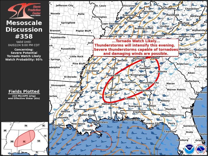
A Tornado Watch is likely to be issued soon, according to the latest information from the National Weather Service. Here are the key details:
• Validity: From 2253Z to 0200Z (time in UTC)
• Probability of Watch Issuance: 95 percent
Thunderstorms are expected to increase in number through the evening, bringing a higher risk of tornadoes and damaging winds. Watch issuance is anticipated within the next few hours.
A warm and moist air mass with moderate instability is present across southern Mississippi and Alabama, with dewpoints in the mid to upper 60s. Radar observations indicate isolated showers and thunderstorms forming in this area. Models indicate the development of a strong southerly low-level jet by mid-evening, leading to northward transport of moisture and strengthening low-level winds. Forecast soundings suggest a rapid increase in hodographs (wind profiles) after dark, creating favorable conditions for supercells capable of producing tornadoes and damaging winds. A tornado watch will likely be issued for parts of this region as convective activity intensifies in the next few hours.
Stay updated with weather alerts and be prepared to take action if a Tornado Watch is issued for your area.
Category: Alabama's Weather, ALL POSTS, Severe Weather
About the Author (Author Profile)
Scott Martin is an operational meteorologist, professional graphic artist, musician, husband, and father. Not only is Scott a member of the National Weather Association, but he is also the Central Alabama Chapter of the NWA president. Scott is also the co-founder of Racecast Weather, which provides forecasts for many racing series across the USA. He also supplies forecasts for the BassMaster Elite Series events including the BassMaster Classic.Subscribe
If you enjoyed this article, subscribe to receive more just like it.


