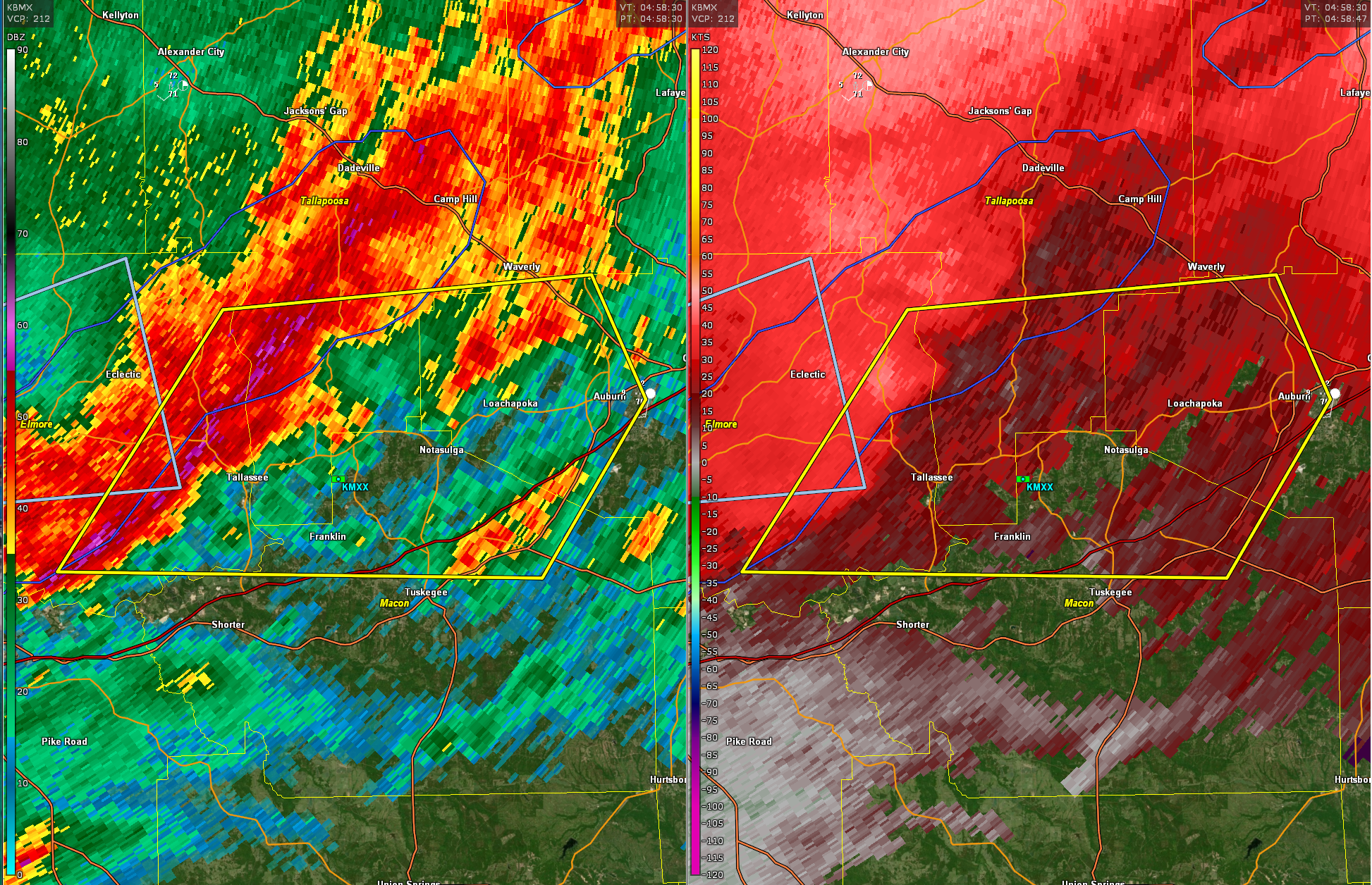
New Severe Thunderstorm Warning for Elmore, Lee, Macon, and Tallapoosa
No tornado at this time, but damaging winds are likely with this storm. The warning includes the Auburn area.
BULLETIN – IMMEDIATE BROADCAST REQUESTED
Severe Thunderstorm Warning
National Weather Service Birmingham AL
1157 PM CDT Tue Apr 2 2024
The National Weather Service in Birmingham has issued a
* Severe Thunderstorm Warning for…
Southeastern Elmore County in east central Alabama…
Northwestern Lee County in east central Alabama…
Northern Macon County in southeastern Alabama…
Southeastern Tallapoosa County in east central Alabama…
* Until 1245 AM CDT.
* At 1156 PM CDT, severe thunderstorms were located along a line
extending from Martin Dam to near Emerald Mountain, moving east at
50 mph.
HAZARD…60 mph wind gusts.
SOURCE…Radar indicated.
IMPACT…Expect damage to roofs, siding, and trees.
* Locations impacted include…
Auburn, Tuskegee, Tallassee, Notasulga, Franklin, Waverly, Martin
Dam, Liberty City, Reeves Airport, Auburn University, Tallapoosa
City, Tuskegee National Forest, Southern Lake Martin, Loachapoka,
Yates Dam, I 85 Rest Area, Uphapee Creek, Ware, Roxana, and
Reeltown.
PRECAUTIONARY/PREPAREDNESS ACTIONS…
For your protection move to an interior room on the lowest floor of a
building.
A Tornado Watch remains in effect until 200 AM CDT for southeastern
and east central Alabama.
&&
LAT…LON 3273 8550 3261 8544 3244 8556 3245 8611
3270 8592
TIME…MOT…LOC 0456Z 265DEG 44KT 3267 8590 3249 8604
HAIL THREAT…RADAR INDICATED
MAX HAIL SIZE…<.75 IN
WIND THREAT...RADAR INDICATED
MAX WIND GUST...60 MPH
Category: Alabama's Weather, ALL POSTS, Severe Weather
About the Author (Author Profile)
Bill Murray is the President of The Weather Factory. He is the site's official weather historian and a weekend forecaster. He also anchors the site's severe weather coverage. Bill Murray is the proud holder of National Weather Association Digital Seal #0001 @wxhistorianSubscribe
If you enjoyed this article, subscribe to receive more just like it.


