Friday Morning Weather Briefing Video: Fine Weather In Store For Your Weekend, Early Part Of Next Week
Your boy gets the privilege and honor of subbing for our main man, James Spann, on this Friday afternoon as he jets off to Northern Illinois University to share his wisdom with students at their AMS Chapter there. Thank you for indulging me the opportunity! Only one video today with a calm period of weather ahead and James out of town.
APRIL, APRIL, DER MACHT WAS ER WILL: I saw this piece of weather folklore in the original German yesterday in The Weather Channel newsletter, which I also enjoy very much. Translated, it says April, April, it does whatever it wants. It means that April’s weather can be very changeable, as it was yesterday across Alabama.
YESTERDAY WAS AN INTERESTING WEATHER DAY ACROSS ALABAMA: The morning started off mostly cloudy across North and Central Alabama with some sunshine across west central portions of the state. The sunny areas quickly filled back in with stratocumulus clouds in the instability created by the warming surface layer and the colder air aloft. Bands of showers moved across the state during the day, and an area of rain moved across the northern third of the state late in the day. Clearing began quickly behind that area of rain and western sections enjoyed at least a little sun to end the day. Temperatures started out in the lower 60s during the morning and rose into the upper 60s to near 70F before beginning to fall during the afternoon. As the trough axis passed through Alabama and a cold knifed through the state, temperatures fell into the 40s overnight.
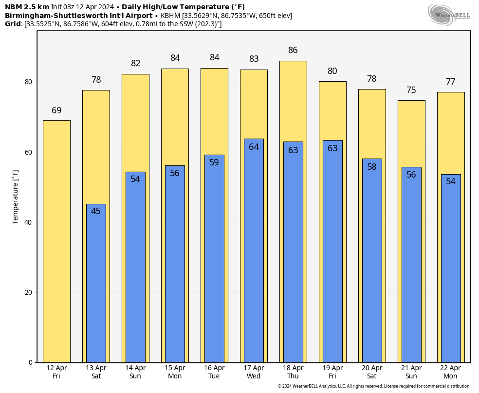
ENTERING A CALM PERIOD: The trough that is over the southeastern United States will lift out to the northeast and a big ridge of high pressure will takes its place in the upper atmosphere. A surface anticyclone will be in place over Alabama by Saturday. Today will feature bright blue robins egg skies across Alabama with few, if any, clouds. Highs today will be in the middle and upper 60s over the northern half of the state, and lower 70s over the south. Lows tonight will be in the 40s again areawide, but fortunately, no frost this go round. Saturday will be an absolutely perfect day for all of the outdoor plans scheduled, including the home opener for the Birmingham Stallions at Protective Stadium. Temperatures will top out in the upper 70s. Sunday highs will be in the 80s with near total sunshine, although a few clouds could tease North Alabama during the afternoon and overnight.
NEXT WEEK: An upper ridge will set the stage for the warmest week so far this year with daily highs in the low to mid 80s. There could even be some upper 80s across South Alabama through the week. Monday and Tuesday will be partly cloudy to partly sunny, but showers will enter northwestern Alabama during the overnight hours Tuesday. A few showers and storms will affect areas mainly northwest of I-59 during the day. Highs both days will be in the 80s, with lows in the upper 50s to middle 60s. We move into a progressive period with fast moving systems for the end of the week, with showers departing in time for dry conditions on Thursday, but rain and storms return on Friday. Some of those storms could be strong, especially across Central Alabama. Saturday will be dry, and then Sunday will feature more rain, but no severe weather.
VOODOO COUNTRY: The following week looks really nice with dry, mild weather.
BEACH FORECAST CENTER: Rain will not return to the beautiful beaches of Alabama and Northwest Florida until Wednesday night, and even then it will be only a few light showers. It is going to be a nearly perfect week to be at the beach, with highs in the upper 70s and lows in the 50s and eventually 60s. Water temperatures are in the upper 60s, still a little cool for my blood. The rip current risk will be low to moderate through the weekend. Get the latest weather and rip current forecasts for the beaches from Fort Morgan to Panama City on our Beach Forecast Center page. There, you can select the forecast of the region that you are interested in visiting.
NATIONAL NOTES: Heavy rains caused flooding across a wide area of western Pennsylvania overnight. A flash flood emergency was issued for Allegheny and Washington Counties on the western side of Pittsburgh where 3-5 inches of rain fell. There were numerous road closures and mudslides as well as fire assistance calls for flooded basements. Tornado watches were issued for areas from Eastern Kentucky to Central Virginia during the day and overnight, and for the Florida Panhandle during the morning. A fairly significant tornado touched down in areas west of St. Augustine, Florida during the morning.
WEATHERBRAINS: Next week, the panel will entertain Weather Channel Legend Heather Tesch. Troy will lead the interview this week as I will be at the Tyler Childers concert in Legacy Arena Monday night. I hate I am going to miss Heather’s appearance. We will all just watch it or listen to it later! Check out the show at www.WeatherBrains.com. You can also subscribe on iTunes. You can watch the show live on our new YouTube channel for the show.You will be able to see the show on the James Spann 24×7 weather channel on cable or directly over the air on the dot 2 feed.
ON THIS DATE IN 1979: Up to a foot of rain fell across North Alabama causing severe flooding. Two waves of rainfall inundated much of the state for hours and when it was finished, up to fourteen inches of rain had fallen across parts of West Alabama. Ten inches of rain was reported in the Tuscaloosa/Northport area. Six to eight inches fell across Jefferson County. Village Creek overflowed in the Avondale/Kingston and Ensley areas of Birmingham, forcing 1,500 people from their homes. The Warrior River crested nineteen feet above flood stage in Tuscaloosa . Much of the city of Northport, AL was under water. Follow my weather history tweets on Twitter. I am @wxhistorian at Twitter.com.
Category: Alabama's Weather, ALL POSTS
About the Author (Author Profile)
Bill Murray is the President of The Weather Factory. He is the site's official weather historian and a weekend forecaster. He also anchors the site's severe weather coverage. Bill Murray is the proud holder of National Weather Association Digital Seal #0001 @wxhistorianSubscribe
If you enjoyed this article, subscribe to receive more just like it.


