Sunday Weather Briefing Video: A Great Sunday
GENERAL OUTLOOK: The weather forecast for North and Central Alabama over the next week shows a mix of sunny days and potential showers, with mild to warm temperatures prevailing.
SATURDAY’S WEATHER: Today, expect sunny weather with temperatures reaching up to the upper 70s to low 80s. A northwesterly flow, accompanied by light winds, dominates due to a surface high pressure centered over Louisiana. This evening, the low will move off the Alabama coastline, maintaining light to calm winds throughout the area.
FOR YOUR SUNDAY: Sunday will continue to be sunny with the high pressure moving off the west coast of Florida. This shift will cause the winds to turn more southwesterly, a little gusty at times due to the pressure gradient. Temperatures are expected to climb a bit higher, ranging from low to mid-80s. The weather will stay predominantly sunny with some possible fair weather cumulus and high cirrus clouds.
MONDAY, MONDAY: The beginning of the week will see an upper-level ridge moving across the Deep South, leading to dry and warm conditions with afternoon temperatures expected to stay in the low to mid-80s. The day will likely be sunny with some clouds increasing later on.
MIDWEEK OUTLOOK: Tuesday will see the warming trend continued with highs in the low to mid 80s. Clouds will begin to increase during the day on Tuesday. By Tuesday night into Wednesday, a weakening front from the Plains towards the Great Lakes and Ohio Valley will bring scattered showers and thunderstorms, primarily to the northern and central parts of Alabama. The cold front will pass during during the day. With rain arriving Tuesday night into Wednesday morning, the chances for destabiliztion of the airmass will be minimal, leading us to believe the threat of severe weather. But an arrival on Tuesday evening could spell a different story, so we will be monitoring. A dry slot will lower our rain chances for Wednesday evening.
LATE WEEK: Another trough from the Upper Midwest and Great Lakes will approach on Thursday. This should energize the rain machine for another round of showers and storms during the day, pushing into South Alabama by evening.
WEEKEND OUTLOOK: Friday looks dry again, but another upper disturbance will refire shower and thunderstorm chances by Friday night. Saturday looks wet, unfortunately, especially for Talladega fans. Showers may continue into Sunday, but a washout doesn’t look likely. That portends well for the Sunday race as the World’s Fastest Speedway.
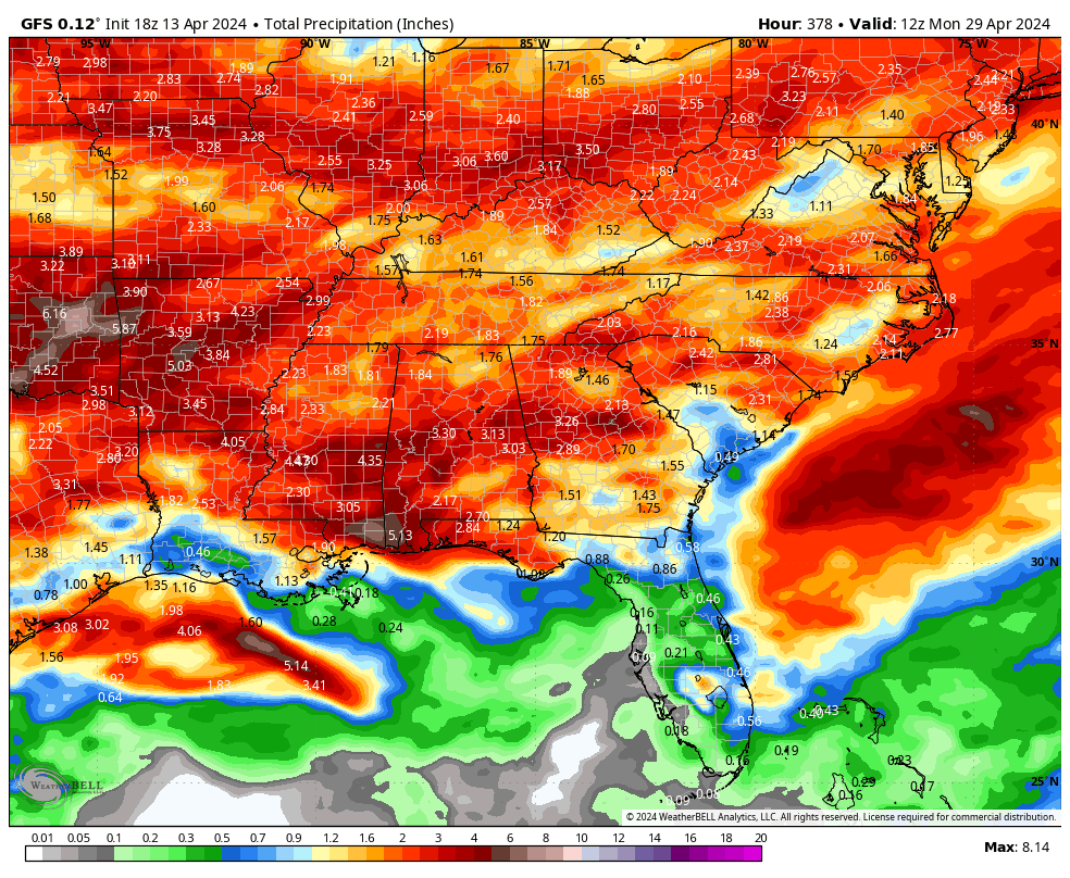
RAINFALL TOTALS: Week one totals are about one-half inch over the northern half of the state. Week two looks more promising in this department, with 1-3 inches likely in most areas.
DROUGHTLOOK: The drought situation in Alabama is looking really good now, with the only deficient rainfall areas over parts of Mobile and Baldwin counties. That means those week two rains could be very positive in eradicating that dryness.
SEVERE WEATHER SAFETY: Weather can be unpredictable, catching us off guard with its sudden changes. From thunderstorms to tornadoes or flash floods, being ready beforehand can be a lifesaver. Alabama, with its varied climate, faces its share of severe weather. That’s why having a solid safety plan is so important for everyone. Check out our Severe Weather Safety Guide for valuable tips on how to stay safe when severe weather is on the horizon.
BEACH FORECAST CENTER: Please visit our Beach Forecast Center page to access the most up-to-date weather and rip current forecasts for the beaches spanning from Fort Morgan to Panama City. On this platform, you can choose the forecast specific to the region you intend to visit, ensuring you have accurate and relevant information for your plans.
ADVERTISE ON THE BLOG: Ensure you don’t miss this opportunity! Allow us to tailor a bespoke package designed to meet the unique requirements of your organization. Our offerings are creative, flexible, and affordably priced. For further details and inquiries, please reach out to Bill Murray at (205) 687-0782.
E-FORECAST SIGN UP: Receive the Alabama Weather Blog’s comprehensive Seven-Day Forecast directly to your inbox via email, delivered twice daily. Recognized as the most detailed weather forecast accessible in Central Alabama, our service ensures you stay informed and prepared. Subscribe now to access this valuable resource at no cost!
ON THIS DATE IN 2021: A SEACOR Power lift boat capsized in Gulf of Mexico near Port Fourchon, LA amid violent weather, high winds due to wake low and 8mb pressure gradient. Coast Guard rescued 5, 7 died, 7 missing. Safety reviews followed.
Category: Alabama's Weather, ALL POSTS
About the Author (Author Profile)
Bill Murray is the President of The Weather Factory. He is the site's official weather historian and a weekend forecaster. He also anchors the site's severe weather coverage. Bill Murray is the proud holder of National Weather Association Digital Seal #0001 @wxhistorianSubscribe
If you enjoyed this article, subscribe to receive more just like it.


