

Midday Nowcast: Mainly Sunny, Warm Days
WARMEST WEEK SO FAR: Temperatures are rising into the mid 80s across Alabama this afternoon, with a sky featuring plenty of sunshine. Not much change tomorrow as temperatures will again be in the mid-80s with passing clouds.
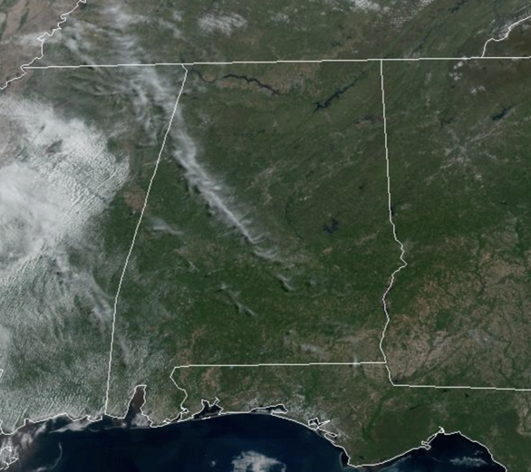
A few showers are possible Wednesday afternoon and evening for the northern third of the state as a dynamic storm system passes well north of Alabama. Rain amounts, where it falls, will be light and spotty. With the added clouds, we are expecting highs in the upper 70s to low 80s. Thursday will be dry with temperatures surging into the mid and upper 80s, and should be the warmest day for most of Alabama so far this year.
BIRMINGHAM ALMANAC: For April 15th, the average high for Birmingham is 75° and the average low is 52°. The record high is 88° set in 1936, while the record low is 31° set in 1950. We average 0.17” of precipitation on this date, and the record value is 1.76” set in 1922.
FRIDAY AND THE WEEKEND: A surface front will approach from the northwest, and we will bring in a chance of showers on a daily basis Friday through the weekend. Rain amounts should be generally under 1/2 inch over the these three days, and no individual day will be a wash-out. But, just understand that if you have something planned outside occasional showers are likely. The high Friday will be in the low 80s, followed by upper 70s Saturday, and upper 60s Sunday as cooler air drops into the Deep South. There could be a rumble of thunder, but no risk of severe storms Friday through Sunday.
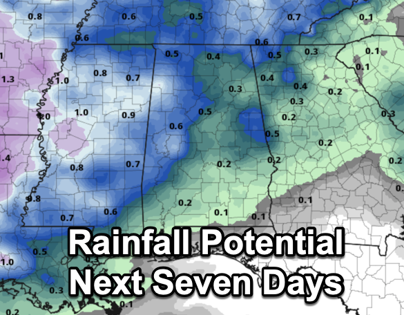
RACE WEEKEND: The sky will be mostly cloudy at Talladega this weekend, and we have the risk of showers both days. Understand this won’t be a wash-out, but rain delays are certainly possible for the races Saturday, and the Geico 500 Sunday. The high Saturday will be in the 75-79 degree range, followed by upper 60s Sunday.
BEACH FORECAST CENTER: Get the latest weather and rip current forecasts for the beaches from Fort Morgan to Panama City on our Beach Forecast Center page. There, you can select the forecast of the region that you are interested in visiting.
WORLD TEMPERATURE EXTREMES: Over the last 24 hours, the highest observation outside the U.S. was 112.8F at Ndjamena, Chad. The lowest observation was -86.3F at Concordia, Antarctica.
CONTIGUOUS TEMPERATURE EXTREMES: Over the last 24 hours, the highest observation was 106F at Rio Grande Village, TX. The lowest observation was 18F at Foxpark, WY.
WEATHER ON THIS DATE IN 2011: The “Forgotten” Tornado Outbreak of April 15, 2011, when 45 tornadoes touched down across West, Central, and South Alabama. Five EF-3 tornadoes did the most damage and claimed the lives of four people in the Boones Chapel community in Autauga County.
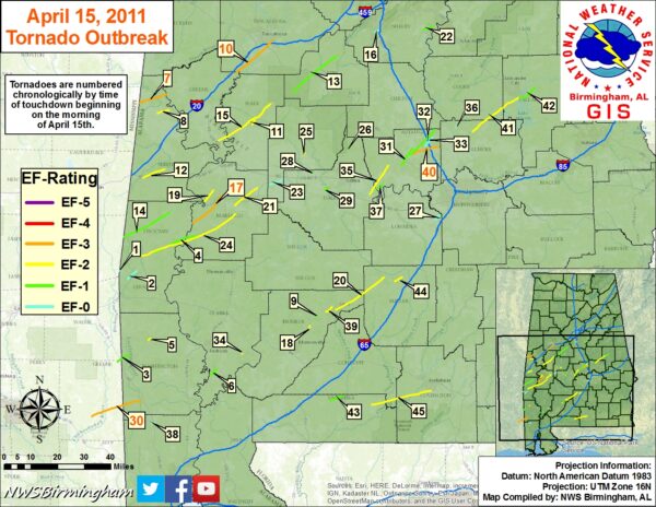
Additionally, there were 17 EF-2s, 14 EF-1s, nine EF-0s tornadoes. It was at the time, the most active tornado day in Alabama history. However, it is deemed the “Forgotten Outbreak” by many due to what would happen 12 days later on April 27, 2011, when a generational tornado outbreak of 62 tornadoes would kill 252 people in Alabama.
Category: Alabama's Weather, ALL POSTS
About the Author (Author Profile)
Macon, Georgia Television Chief Meteorologist, Birmingham native, and long time Contributor on AlabamaWX. Stormchaser. I did not choose Weather, it chose Me. College Football Fanatic. @Ryan_StinnetSubscribe
If you enjoyed this article, subscribe to receive more just like it.


