

Stormy At Times Tonight/Tomorrow
RADAR CHECK: We have a few isolated, small showers across Alabama this afternoon, otherwise the sky features a mix of sun and clouds with temperatures mostly in the 80s. Low 90s are being reported across the southeast counties of the state; Ozark is up to 93 degrees at mid-afternoon.
We have a complex pattern ahead for the next 36 hours. Here is a breakdown of what to expect…
TONIGHT: High resolution models suggest a few thunderstorms could form this evening (in the 6pm to midnight) time frame across the Tennessee Valley. If these do form, they could be strong with potential for some small hail and strong, gusty winds.
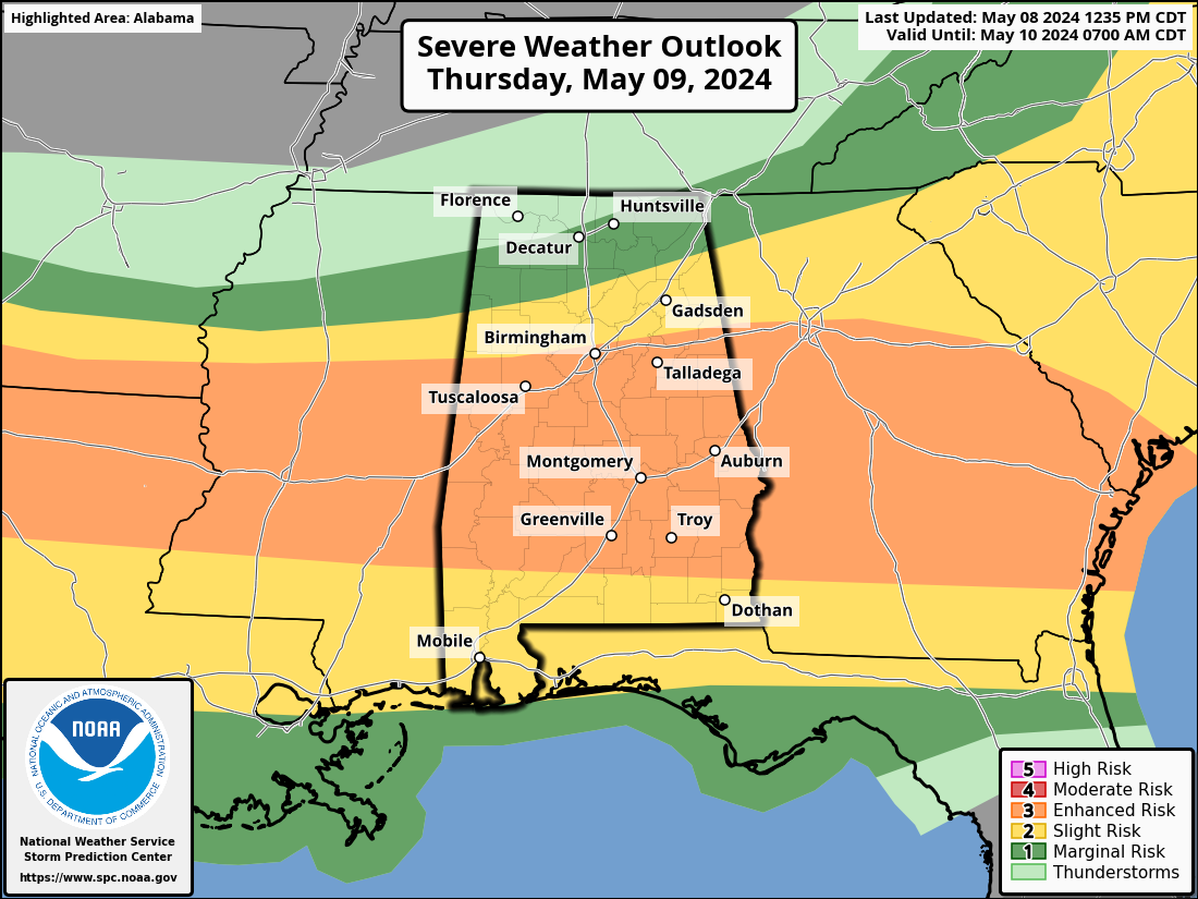
TOMORROW MORNING: An organized batch of rain and storms will move into the Tennessee Valley of North Alabama after midnight (the pre-dawn hours tomorrow). These storms could be strong to severe with potential for damaging wind and some hail. A brief, isolated tornado can’t be ruled out. The storms will move slowly southward, reaching the I-20/59 corridor (Birmingham, Tuscaloosa, Anniston, Gadsden) by mid-morning tomorrow. Again, the main concern will come from straight line winds and small hail, but the chance of a brief tornado is non-zero.
These showers and storms will drift into South Alabama and slowly weaken tomorrow afternoon.
TOMORROW NIGHT: There is a chance that additional thunderstorms could form again tomorrow night (after 6:00 p.m.) ahead of a cold front. High resolution model guidance suggests the air will be unstable, and these storms could become severe. SPC has introduced an “enhanced risk” (level 3/5) for parts of Central Alabama… the main concern is from straight line winds, but again, an isolated tornado can’t be totally ruled out. The highest severe weather potential tomorrow night will be along and south of I-20 (south of a line from Tuscaloosa to Birmingham to Anniston).
Showers and storms will shift into South Alabama after midnight tomorrow night.
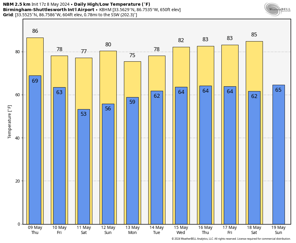
FRIDAY AND THE WEEKEND: Cooler, drier air rolls into Alabama Friday. The sky becomes partly to mostly sunny, and any showers will be confined to the far southern counties of the state. The weekend will feature mostly sunny pleasant days and fair cool nights. Highs will be in the 70s, and lows mostly in the 50s. Colder spots across North Alabama will dip into the 40s early Saturday morning.
NEXT WEEK: We will bring back a chance of showers and thunderstorms Monday and Tuesday as moist air returns… Wednesday looks drier, but showers/storms will need to be in the forecast for part of the day Thursday and Friday based on new model output. See the video briefing for maps, graphics, and more details.
ON THIS DATE IN 1993: Serious flooding occurred in central Oklahoma following torrential rain and hail on this date through the 8th. Rainfall amounts on this date were generally around one inch. Oklahoma City, OK then recorded 6.64 inches of rain on the 8th, the third greatest daily rainfall amount ever observed in the city. Extensive flooding resulted, which killed four people, and the fire department had to rescue 183 others.
Look for the next video briefing here by 6:00 a.m. tomorrow…
Category: Alabama's Weather, ALL POSTS, Weather Xtreme Videos
About the Author (Author Profile)
James Spann is one of the most recognized and trusted television meteorologists in the industry. He holds the AMS CCM designation and television seals from the AMS and NWA. He is a past winner of the Broadcast Meteorologist of the Year from both professional organizations.Subscribe
If you enjoyed this article, subscribe to receive more just like it.


