LIVE BLOG: Updates on North Alabama Outbreak
Refresh this post frequently for the latest information.
1130PM Suspending this running post now…going back to regular posts.
The two tornadic supercells in North Alabama appear to be becoming outflow dominant now and will hopefully weaken. The NWS in Atlanta has issued a PDS Tornado Warning in case it doesn’t for their areas on their side of the border.
1126PM TORNADO EMERGENCY
BULLETIN – EAS ACTIVATION REQUESTED
Tornado Warning
National Weather Service Huntsville AL
1125 PM CDT Wed May 8 2024
The National Weather Service in Huntsville Alabama has issued a
* Tornado Warning for…
East central DeKalb County in northeastern Alabama…
* Until 1145 PM CDT.
* At 1124 PM CDT, a confirmed large and extremely dangerous tornado
was located near Henagar, or 10 miles northeast of Fort Payne,
moving east at 35 mph. This tornado has caused significant damage
in Henagar, AL.
This is a PARTICULARLY DANGEROUS SITUATION. TAKE COVER NOW!
HAZARD…Damaging tornado.
SOURCE…Radar and spotter confirmed tornado.
IMPACT…You are in a life-threatening situation. Flying debris
may be deadly to those caught without shelter. Mobile
homes will be destroyed. Considerable damage to homes,
businesses, and vehicles is likely and complete
destruction is possible.
* This tornadic thunderstorm will remain over mainly rural areas of
east central DeKalb County, including the following locations…
Hammondville, Mentone, and Valley Head.
PRECAUTIONARY/PREPAREDNESS ACTIONS…
To repeat, a large, extremely dangerous and potentially deadly
tornado is on the ground. To protect your life, TAKE COVER NOW! Move
to a basement or an interior room on the lowest floor of a sturdy
building. Avoid windows. If you are outdoors, in a mobile home, or in
a vehicle, move to the closest substantial shelter and protect
yourself from flying debris.
1125PM
Starting to get damage reports from DEKalb County in the Henagar area along AL-75. Trees down on homes and on roads.
Lots of reports of damage from around Henagar.
1117PM
Folks in Valley Head and Hammondville need to be in the safe places now. Power flashes were seen on tower cams near Henagar.
The tornado will be crossing I-59 shortly near Hammondville.
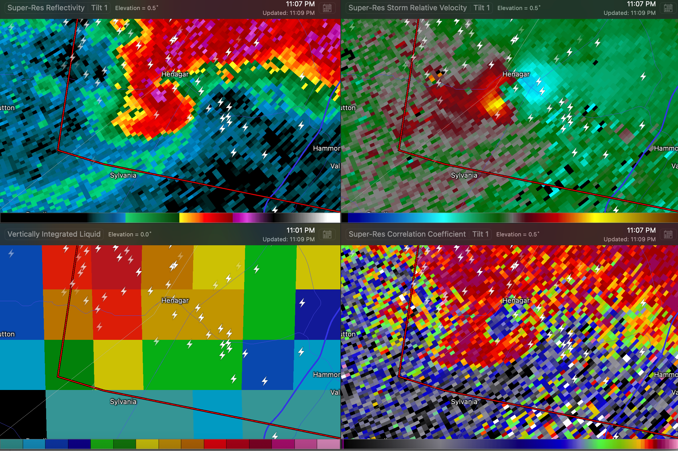
1110PM TORNADO EMERGENCY!!
…TORNADO EMERGENCY FOR Henagar, Hammondville, and Mentone…
…A TORNADO WARNING REMAINS IN EFFECT UNTIL 1130 PM CDT FOR EAST
CENTRAL DEKALB COUNTY…
At 1108 PM CDT, a confirmed large and destructive tornado was located
over Henagar, or 9 miles north of Rainsville, moving east at 20 mph.
TORNADO EMERGENCY for Henagar, Hammondville, and Mentone. This is a
PARTICULARLY DANGEROUS SITUATION. TAKE COVER NOW!
HAZARD…Deadly tornado.
SOURCE…Radar confirmed tornado.
IMPACT…You are in a life-threatening situation. Flying debris may
be deadly to those caught without shelter. Mobile homes
will be destroyed. Considerable damage to homes,
businesses, and vehicles is likely and complete destruction
is possible.
The tornado will be near…
Henagar and Ider around 1115 PM CDT.
Other locations impacted by this tornadic thunderstorm include
Sulpher Springs, Valley Head, Mentone, and Hammondville.
PRECAUTIONARY/PREPAREDNESS ACTIONS…
To repeat, a large, extremely dangerous, and potentially deadly
tornado is on the ground. To protect your life, TAKE COVER NOW! Move
to an interior room on the lowest floor of a sturdy building. Avoid
windows. If in a mobile home, a vehicle or outdoors, move to the
closest substantial shelter and protect yourself from flying debris.
1109 TDS South of Henagar
A tornado debris signature just exploded in Jackson County south of Henagar.
1101 PM TORNADO APPROACHING HENAGAR
Strong indications of rotation on radar west of Henagar. Everyone in and around the town of Henagar must be in their safe place now!!!
1058PM FLASH FLOOD WARNING
The National Weather Service in Huntsville has issued a
* Flash Flood Warning for…
East Central Limestone County in north central Alabama…
Central Madison County in north central Alabama…
West Central Jackson County in northeastern Alabama…
* Until 200 AM CDT.
* At 1056 PM CDT, Trained weather spotters reported thunderstorms
producing heavy rain across the warned area, with localized flash
flooding reporting. Between 1 and 3 inches of rain have fallen.
Flash flooding is ongoing or expected to begin shortly.
HAZARD…Flash flooding caused by thunderstorms.
SOURCE…Trained spotters reported.
IMPACT…Flash flooding of small creeks and streams, urban
areas, highways, streets and underpasses as well as
other poor drainage and low-lying areas.
* Some locations that will experience flash flooding include…
Huntsville, Madison, Athens, Scottsboro, Moores Mill,
Meridianville, Redstone Arsenal, Hollywood, Skyline, Gurley,
Alabama A And M University, University Of Alabama In Huntsville,
Harvest, Pleasant Groves, Ryland, Brownsboro, Maysville, Garth,
Trenton and Hollytree.
PRECAUTIONARY/PREPAREDNESS ACTIONS…
Turn around, don’t drown when encountering flooded roads. Most flood
deaths occur in vehicles.
Be especially cautious at night when it is harder to recognize the
dangers of flooding.
In hilly terrain there are hundreds of low water crossings which are
potentially dangerous in heavy rain. Do not attempt to cross flooded
roads. Find an alternate route.
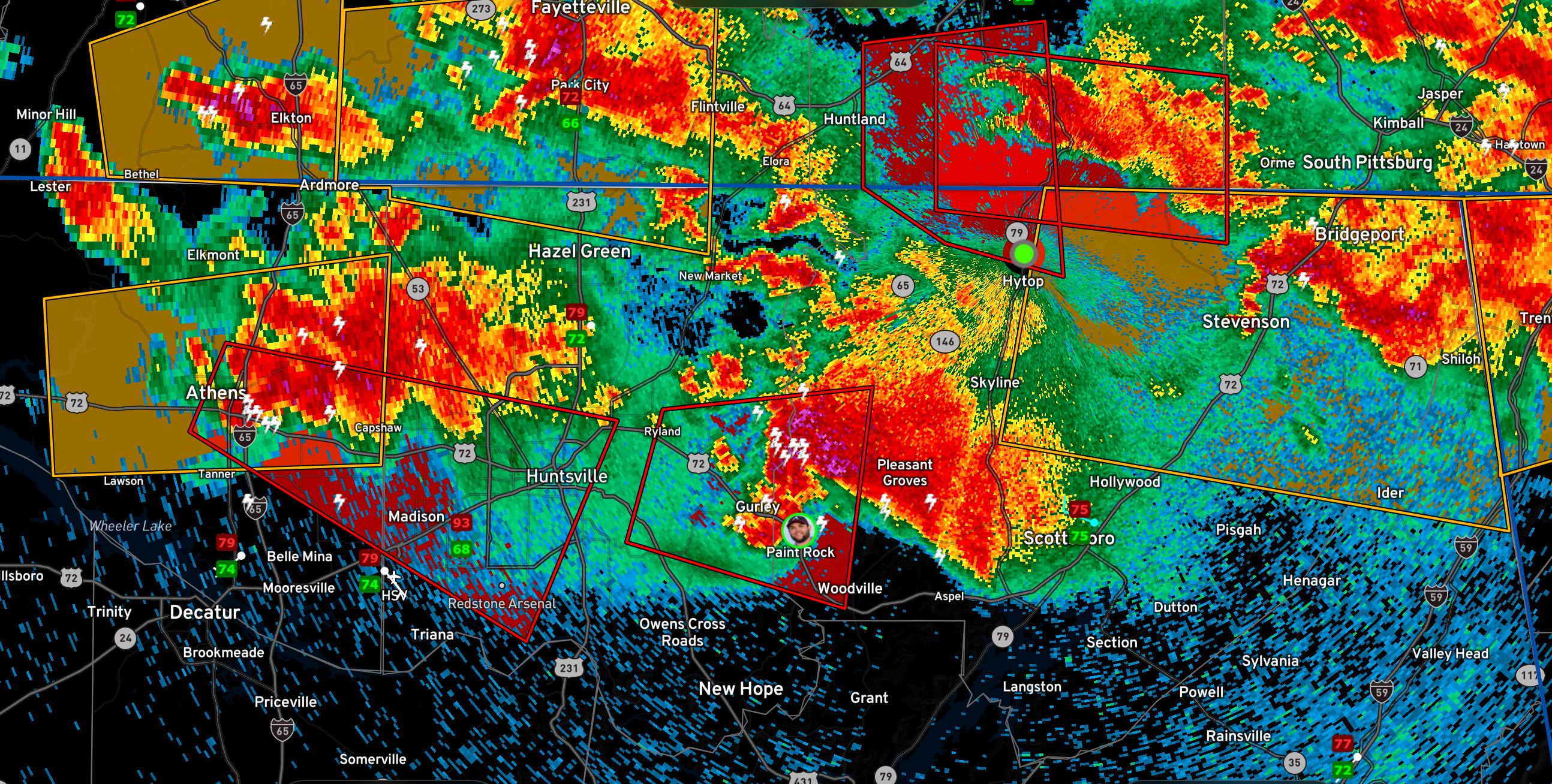
1046PM
The second Huntsville tornado is taking a similar path to the first. Chasers have a cone tornado sighted on the ground now.
1045PM
Flooding is becoming severe in Tennessee including a flash flood emergency. Make sure friends and family know that the flooding is serious tonight.
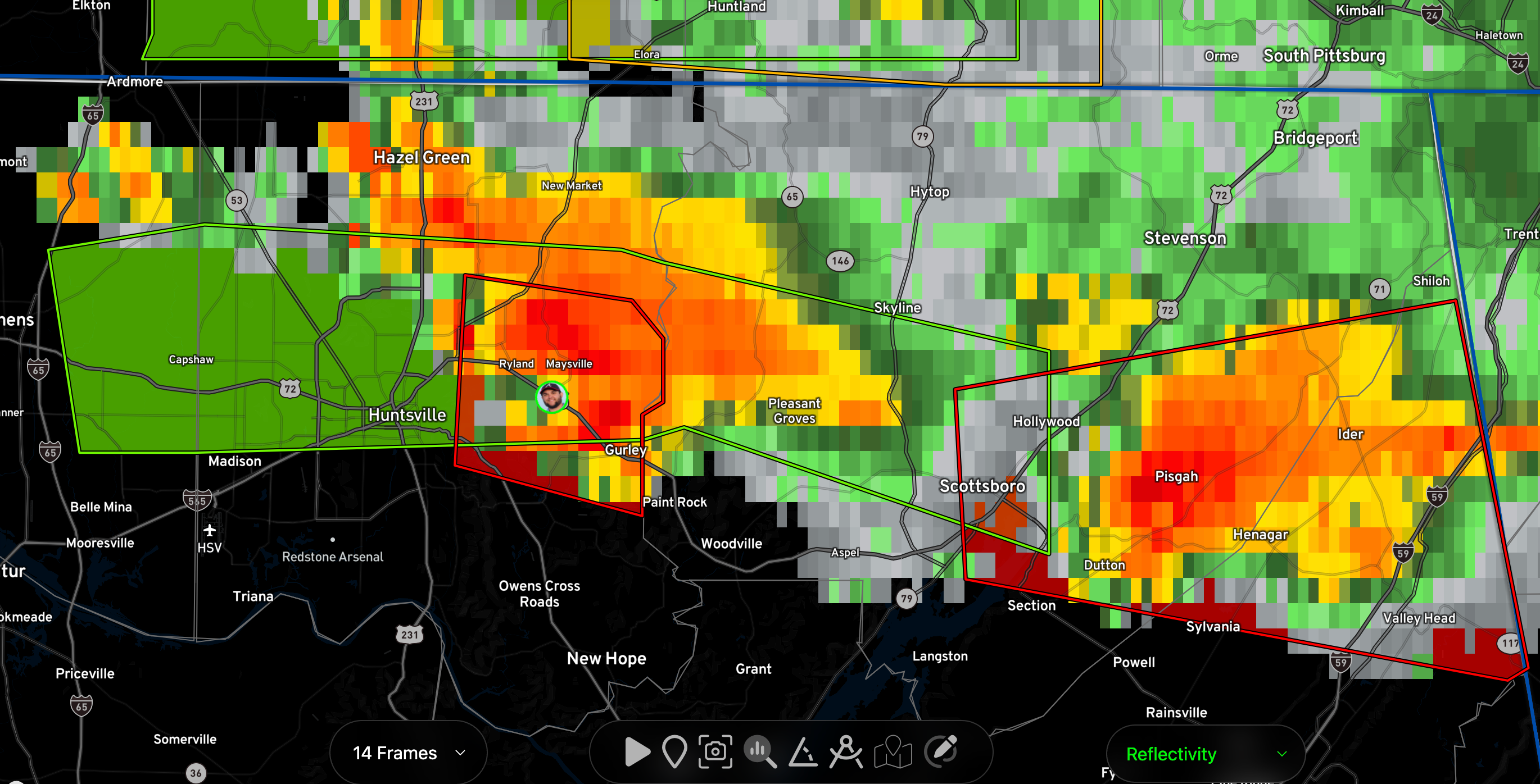
1044PM
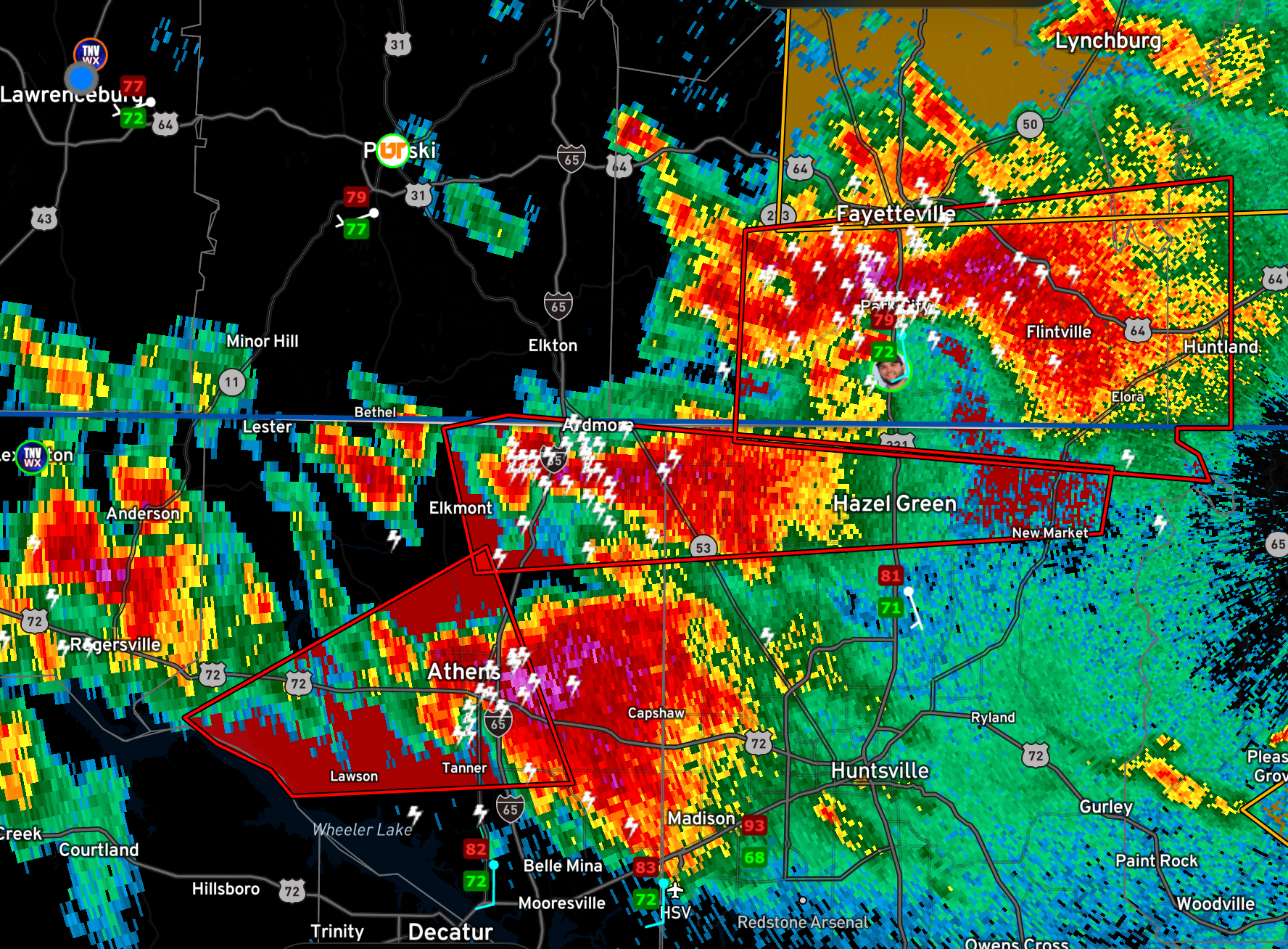
The Jackson County storm has a new tornado warning that includes areas east of Scottsboro including Henagar and Pisgah.
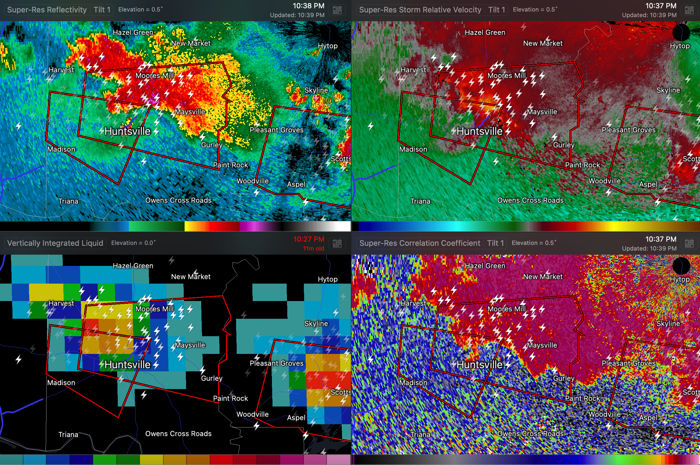
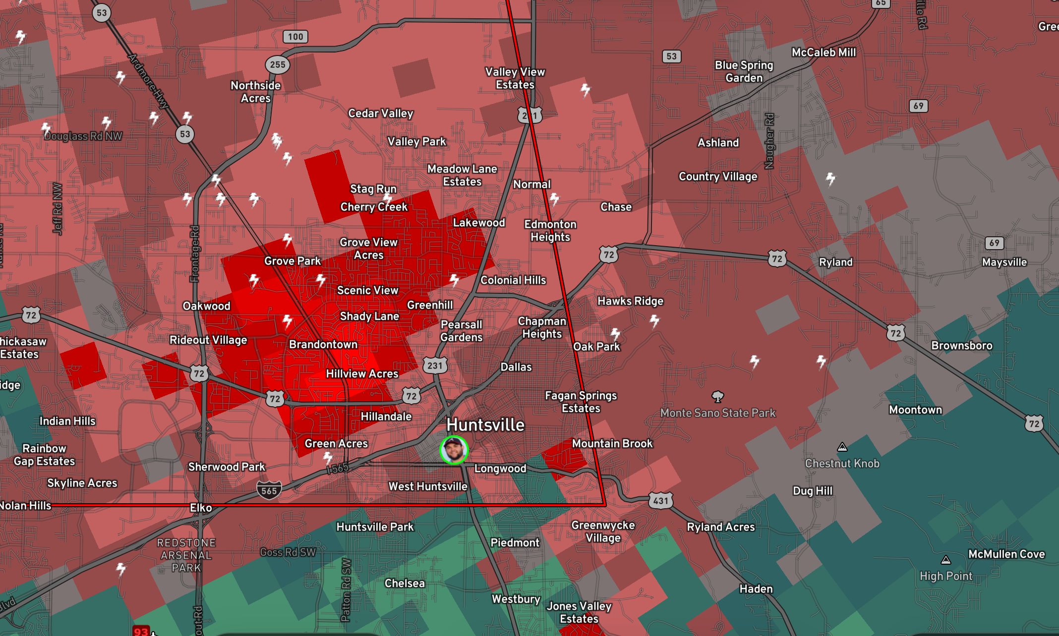
1039PM Another tornado on the ground in Huntsville. Near Cherry Creek on north side of Huntsville.
1025PM
Tornado on the ground near Lime Rock in Jackson County.
1021PM
Supercell near Madison could produce a tornado at any time.
1018PM
Another TDS near Scottsboro. Be in safe shelter now!
1004PM
The storm that produced the Huntsville tornado has prompted a tornado warning for Jackson County. The dangerous art of the storm is moving toward Scottsboro.
10PM RADAR
954PM
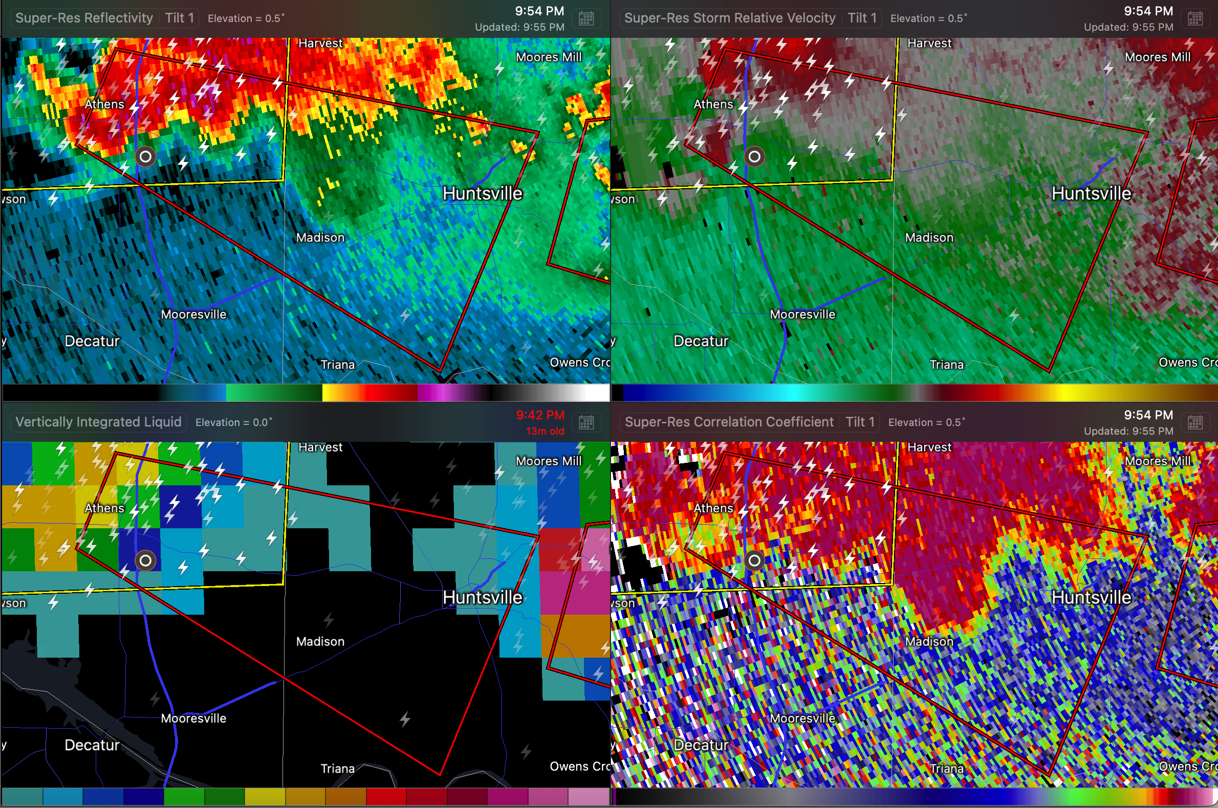
Rotation near Athens at the 72/I-65 interchange. Tornado warning for Limestone and Madison Counties.
947PM
Circulation has weakened, but storm may be cycling. Tornado warning remains in effect. Storm is approaching areas near an north of Gurley. NWS Huntsville has relayed a reoprt from EMA that there is damage in the Five Points section of Huntsville.
938PM GURLEY BE IN SAFE SHELTER
Strong rotation indicating damaging tornado is moving east southeast toward Gurley along US-72.
935PM
PDS Tornado Warning for areas just east of Huntsville. Moving toward Dug Hill and McMullen Cove. Large damaging tornado on the ground in the vicinity of US-431. Take shelter now!!!
933PM
Huntsville storm is showing right turn indications. Folks along US-72 down to Gurley, Paint Rock, and Woodville need to be in teh safe places now!!!
931 PM
Multiple sources reporting tornado on the ground northern side of Huntsville.
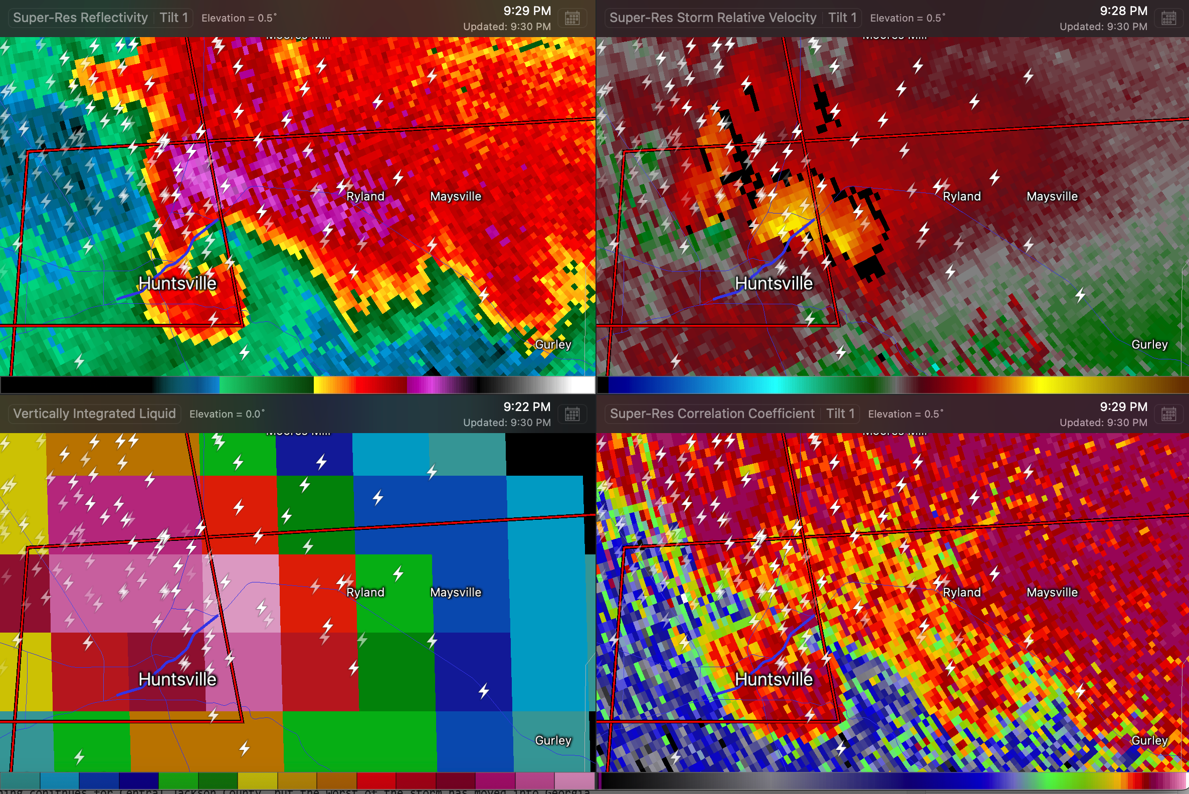
927PM
New Tornado Warning for Madison and Jackson Counties…tornado observed by storm chasers near Chapman Mountain or over eastern Huntsville…moving east at 35. Will move over US-72 northwest of Gurley. We want our friends in Ryland, Gurley, Maysville, and Paint Rock to be in their safe shelters.
927PM
Tornado warning continues for Central Jackson County, but the worst of the storm has moved into Georgia.
925PM
There continues to be a tornado warning for northern Madison and Jackson Counties, but the subject storm is in Tennessee and should stay north of the border.
924PM
Chasers reporting power flashes in northern Huntsville.
920PM
The tornado warning for Madison County has been upgraded to RADAR CONFIRMED. Neighborhoods on the northern side of Huntsville need to be in safe shelter. The storm definitely has a hook echo. There is no debris signature although reflectivity may be showing derbis ball.
912PM
Strong rotation on US-72 west northwest of Huntsville. This is on the northern side of Madison. This possible tornado could affect northern parts of Huntsville.
911PM
Another storm is intensifying south of Rogersville…not warned at this time.
907 PM TORNADO WARNING
For Madison and Jackson Counties…very strong indications of a tornado in southern Tennssee west of Huntland. Circulation should stay in Tenenssee…
…NWS Huntsville reporting that the Lauderdale/Limestone storm tightened briefly…about to enter Limestone County…moving west northwest
9:06PM UPDATE
Severe thunderstorm warning for Lauderdale and Limestone. Severe storm south of Anderson moving toward Elkmont.
Tornado warning for northern Limestone/Madison Counties…multiple severe storms moving across this warning. Best rotation is south of Ardmore
Tornado warning for Limestone and Madison Counties…severe storms along I-565 west of Huntsville. Broad rotation northwest of Madison.
Tornado warning for Jackson and DeKalb…rotation east of Hollywood. Lots of heavy rain and hail with this.
Tornado warning for DeKalb…strongest part of storm about to enter Georgia…rotation northeast of Valley head.
Damage Report: home destroyed near Brigadoon in Limestone Co, on the Tennessee River.
853PM NEW TORNADO WARNING FOR LIMESTONE AND MADISON
Strengthening rotation southeast of Athens. Will move near Copeland, Fairview, Clarksdale, and south of Harvest. Large hail and very heavy rain on the northern side of the storm.
848PM RADAR AND TORNADO WARNINGS
845PM MODERATE RISK EXPANDED INTO NORTH ALABAMA BY SPC
The SPC has upgraded parts of North Alabama to a level 4/5 Moderate Risk.
…THERE IS A MODERATE RISK OF SEVERE THUNDERSTORMS FROM SOUTHEAST
MO INTO WESTERN KY…WESTERN/MIDDLE TN…NORTHERN AL…FAR NORTHWEST
GA…
CORRECTED FOR WIND GRAPHIC
…SUMMARY…
Severe thunderstorms remain likely this evening from parts of the
mid Mississippi, Ohio, and Tennessee Valleys into the southern
Plains. All severe hazards, including tornadoes, very large hail,
and potentially significant damaging winds are possible. Some
tornadoes may be strong, especially this evening from far northern
Alabama into southeast Tennessee.
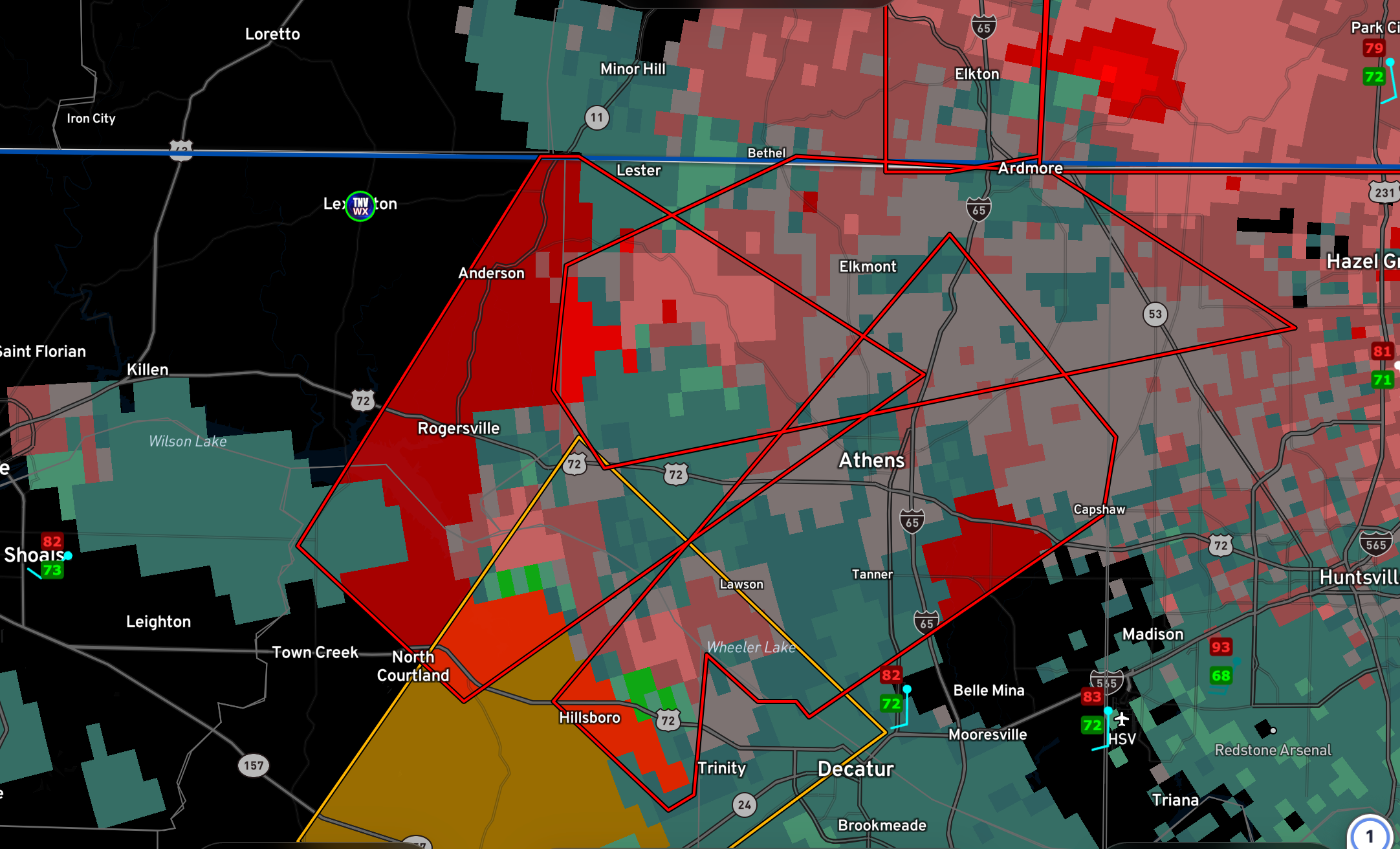
CIRCULATION EAST OF ELKMONT 842 PM
The rotation is strengthening and about to cross I-65 east of Elkmont, AL. Will move northeast to near or south of Ardmore AL. Be in safe shelter in the tornado warning.
RADAR AND WARNINGS AT 840 PM
827 pm
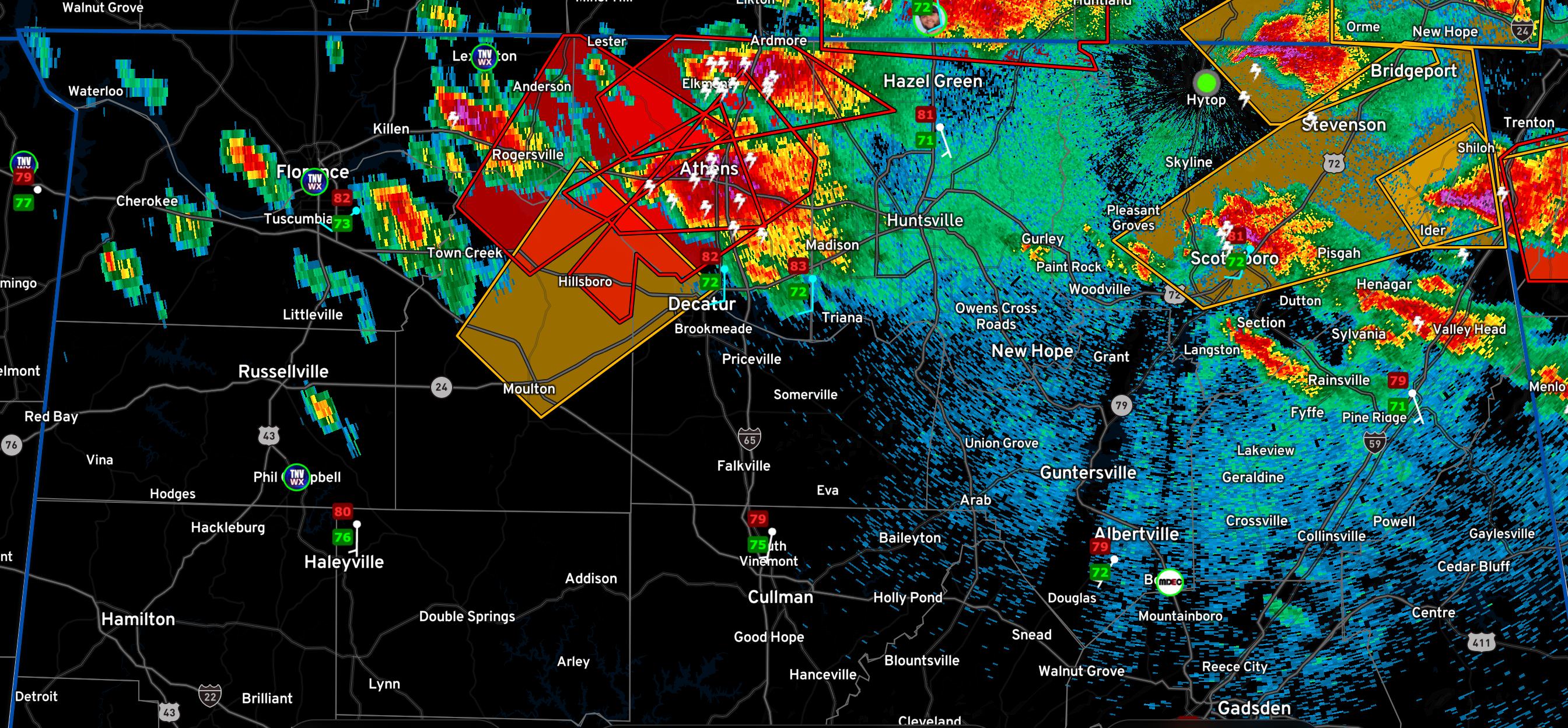
Tornado debris signature in southern Limestone County near Ripley, south of Coxey. Will reach Athens around 843p. Tornado is on the ground.

820 pm
Multiple possible tornadoes are on the ground in Lawrence County in North Alabama…
Several dangerous storms are moving across the Tennessee Valley of North Alabama.
New tornado warning for parts of Limestone and Lawrence counties til 845pm. Possible tornado on the ground near the Tennessee River southwest of Coxey. The other is southwest of Lawson southwest of Athens. These storms seem to be merging.
Category: Alabama's Weather, ALL POSTS, Severe Weather
About the Author (Author Profile)
Bill Murray is the President of The Weather Factory. He is the site's official weather historian and a weekend forecaster. He also anchors the site's severe weather coverage. Bill Murray is the proud holder of National Weather Association Digital Seal #0001 @wxhistorianSubscribe
If you enjoyed this article, subscribe to receive more just like it.


