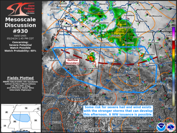
Strong Storms Etowah and St. Clair…SPC Says 40% Chance of a Watch for North and Central Alabama
A strong storm has formed just northwest of Gadsden. It is moving northeast at 25-30 mph. Lots of heavy rain and lightning. Winds could gust to 50 mph as well. Hail could reach size of nickels. Other storms are over parts of St. Clair County and Calhoun County.
Other storms are forming along I-59 from Jackson County through DeKalb County from Henagar and Valley Head to Fort Payne and Collinsville.
Decent bulk shear at 43 knots and decent CAPE at 1,362 joules in East Alabama so the storms could become severe especially as instability gradually increases during the afternoon. Downdraft CAPEs are not especially high yet, so the threat of microbursts is relatively low,, but there could easily be damaging wind gusts to 60 mph with stronger storms. Low level helicities are very low so no chance of tornadoes. Precipitable waters are high at 1.6 inches so heavy rain is a possibility if training cells set up over any one area.
Widespread rain with rumbles of thunder covers the central Tennessee valley.
SPC puts the chance of a watch at 40% for North and Central Alabama in a mesoscale discussion.
Mesoscale Discussion 0930
NWS Storm Prediction Center Norman OK
1217 PM CDT Fri May 24 2024
Areas affected…portions of northern and central
Mississippi…northern and central Alabama
Concerning…Severe potential…Watch possible
Valid 241717Z – 241845Z
Probability of Watch Issuance…40 percent
SUMMARY…At least isolated to potentially scattered instances of
severe wind or hail may occur with the stronger storms across
portions of the Southeast. Convective trends are being monitored for
the need of a WW issuance.
DISCUSSION…Scattered strong thunderstorms have recently developed
along the leading edge of outflow and ahead of an MCV from a
dissipating MCS across northern parts of MS and AL. Immediately
ahead of the outflow boundary, strong diurnal heating is supporting
boundary-layer deepening, with agitated CU already developing, and
over 1500 J/kg MLCAPE evident via 17Z mesoanalysis. Over 50 kts of
westerly 500 mb flow is contributing to strong unidirectional speed
shear and modestly curved/elongated hodographs. Multicells should be
the predominant mode of convection, though a transient supercell or
two cannot be ruled out. Severe wind and hail may accompany the
stronger storms. Coverage of severe storms is still somewhat
uncertain, but convective trends are being monitored for the need of
a WW issuance.
..Squitieri/Guyer.. 05/24/2024
Category: Alabama's Weather, ALL POSTS, Severe Weather


