EXPIRED Severe T-Storm Warning — Parts of Cullman, Franklin, Lawrence, Limestone, Madison, Morgan Co. Until 3:15 am
The National Weather Service in Huntsville, Alabama, has issued a Severe Thunderstorm Warning for several counties in north central and northwestern Alabama.
Affected Counties:
Western Madison County
Southeastern Limestone County
Northwestern Cullman County
Eastern Franklin County
Morgan County
Lawrence County
Remains in Effect Until:
The warning is in effect until 3:15 AM CDT.
Details:
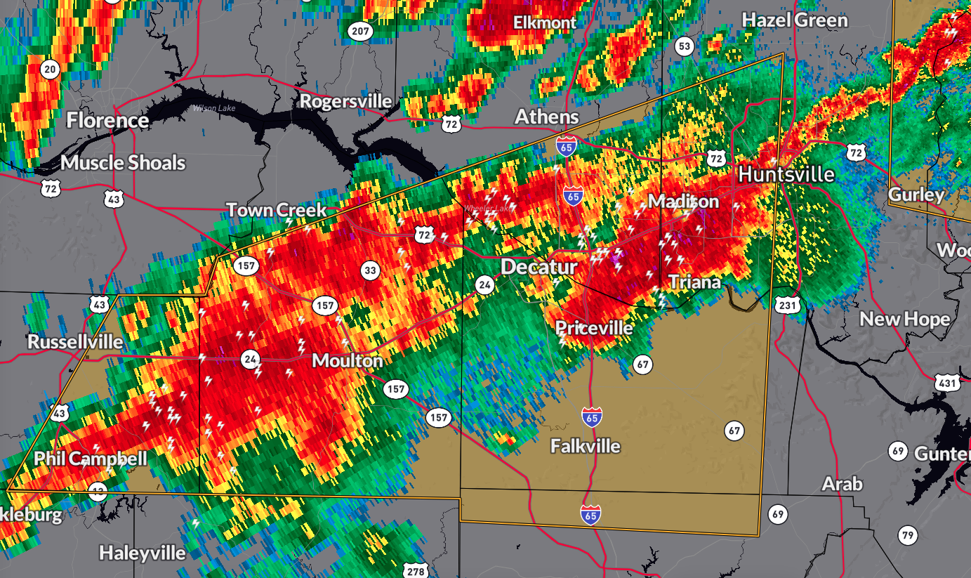
At 2:40 AM CDT, a severe thunderstorm was identified 10 miles west of Moulton, moving east at 45 mph. The storm brings a hazard of 60 mph wind gusts and quarter-size hail, as indicated by radar.
Impact:
Expect hail damage to vehicles and potential wind damage to roofs, siding, and trees in the affected areas, including Huntsville, Decatur, Madison, Athens, Hartselle, Russellville, Moulton, Redstone Arsenal, Meridianville, and Priceville.
Precautionary/Preparedness Actions:
Stay alert for possible tornado development. Tornadoes can form quickly from severe thunderstorms.
Take shelter immediately in a basement or central room of a sturdy building if you spot a tornado.
Move to the lowest floor’s interior room for protection.
Note that a Tornado Watch remains in effect until 5:00 AM CDT for Middle Tennessee and until 8:00 AM CDT for north central, northeastern, and northwestern Alabama. Stay updated with weather alerts and stay safe!
Category: Alabama's Weather, ALL POSTS, Severe Weather
About the Author (Author Profile)
Scott Martin is an operational meteorologist, professional graphic artist, musician, husband, and father. Not only is Scott a member of the National Weather Association, but he is also the Central Alabama Chapter of the NWA president. Scott is also the co-founder of Racecast Weather, which provides forecasts for many racing series across the USA. He also supplies forecasts for the BassMaster Elite Series events including the BassMaster Classic.Subscribe
If you enjoyed this article, subscribe to receive more just like it.


