Midday Nowcast: Sunny and Very Hot Weather
TODAY AND TOMORROW: Today is a hot and mostly dry day with a highs again in the upper 90s and low 100s. Rain chances are very low, but not zero, but really worth mentioning in the forecast. Tomorrow, scattered showers and storms return as the air becomes more unstable and moisture levels rise. It won’t rain everywhere, but rain chances will be in the 40-50%t range. Otherwise, expect a mix of sun and clouds with a high in the upper 90s with some low 100s possible.
OZONE ALERT: The Alabama Department of Environmental Management, ADEM, has issued an Air Quality Alert for Jefferson and Shelby Counties for Tuesday, June 25. Under Code Orange conditions, ground level ozone concentrations are expected to reach levels that are unhealthy for sensitive groups. Children and people with asthma are individuals most at risk under these expected conditions.
BIRMINGHAM ALMANAC: For June 25th, the average high for Birmingham is 90° and the average low is 70°. The record high is 101° set in 1931, while the record low is 49° set in 1974. We average 0.17” of precipitation on this date, and the record value is 1.99” set in 1932.
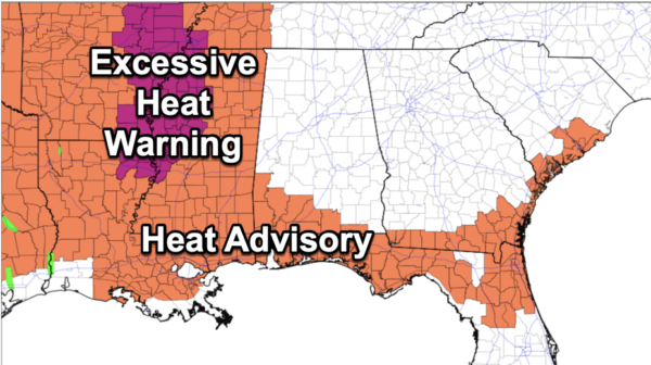
ACROSS THE USA: Severe thunderstorms are possible across the Central Plains into the central Great Lakes Tuesday afternoon and evening. Damaging winds, large hail, and a tornado or two may occur. A Slight Risk (level 2 of 5) of severe thunderstorms is in effect. A heat wave will continue into Tuesday from the Great Plains into the lower Mississippi River Valley and in northern Florida.
THURSDAY THROUGH THE WEEKEND: Routine summer weather is the story for the end of the week and the weekend. Partly sunny, hot, humid days with a few random, scattered, mostly afternoon and evening showers and storms possible. Highs will be in the mid and upper 90s on most days and that heat index will be over 100° at times. Rain chances will be in the 20-30% Thursday through Saturday, and look to increase some to the 30-40% Sunday.
NEXT WEEK: Not much change; highs in the 90s, lows in the 70s. Partly sunny days; the risk of a pop up afternoon shower or storm in scattered spots.
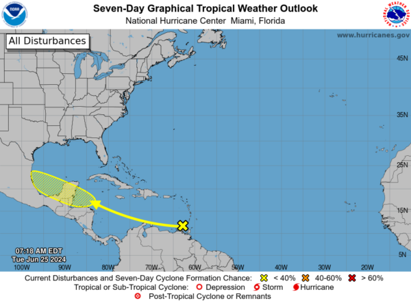
IN THE TROPICS: A westward-moving tropical wave located over the southeastern Caribbean Sea is producing disorganized showers and thunderstorms. Environmental conditions appear conducive for slow development once the wave reaches the western Caribbean late this week. Formation chance through 7 days…low…20 percent. Next name up is Beryl.
BEACH FORECAST CENTER: Highs in the upper 80s and lower 90s with daily afternoon storms. Water temperatures are very warm with mid-80s being reported up and down the Northern Gulf Coast. Again, PLEASE pay attention to the Rip Current Flags System at each beach for the update on rip currents. Low to Moderate rip currents are being reported from Dauphin Island east to Destin, while Panama City is reporting High rip current threats. Get the latest weather and rip current forecasts for the beaches from Fort Morgan to Panama City on our Beach Forecast Center page. There, you can select the forecast of the region that you are interested in visiting.
WORLD TEMPERATURE EXTREMES: Over the last 24 hours, the highest observation outside the U.S. was 121.3F at King Fahad International Airport, Dammam, Saudi Arabia. The lowest observation was -114.8F at Dumont D’Urville, Antarctica.
CONTIGUOUS TEMPERATURE EXTREMES: Over the last 24 hours, the highest observation was 121F at Death Valley and Stovepipe Wells, CA. The lowest observation was 28F at Crescent, OR.
Category: Alabama's Weather, ALL POSTS
About the Author (Author Profile)
Macon, Georgia Television Chief Meteorologist, Birmingham native, and long time Contributor on AlabamaWX. Stormchaser. I did not choose Weather, it chose Me. College Football Fanatic. @Ryan_StinnetSubscribe
If you enjoyed this article, subscribe to receive more just like it.


