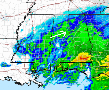
Heavier snow now moving in
Almost 1″ of snow has already accumulated on grassy areas here in Trussville, and the heaviest snow is about to move into the Birmingham area over the next 2 hours. The upper-level disturbance will move on through this afternoon, so the heaviest snow will be between now and 3 pm in TCL and BHM, and maybe after 2 pm in ANB/GAD/FTP.
Temperatures have settled near 32 over most of north and central Alabama, as they often do when it snows. Usually, melting of the snow lowers the temperature to 32, then it stops melting and sticks.
You may have noticed that the snow falling now is in the form of small flakes. This is because temperatures are very cold just above the surface. At 850 mb (4,000 feet), it is about -3 to -4 C (25-27 F). Therefore, the snow is not wet and can’t stick together and form bigger flakes. We rarely see dry, powdery snow like this in the deep South.
So, with the snowflakes falling at 25 degrees, temperatures will hold near 32, or maybe drop to 30 or 31, this afternoon. This will cause bridge icing, and some icing on all roads as the snow continues. If you need to drive anywhere (home from work, etc.), go ahead now. There may already be icy spots, so drive very carefully.
For your meteorological consulting needs, call Coleman and Peters, LLC, at (205) 568-4401, or at colemanpetersllc.com. We help attorneys and insurance people with weather issues in their legal cases.
Category: Uncategorized


