Sunday Video Briefing: A Break in the Heat by Midweek
The heat continues across Alabama, but there is a break in sight as the ridge over the United States weakens in the next few days. Temperatures on Saturday were hot, with highs ranging from 94F at Auburn to 101F at Eutaw. Across Central Alabama, highs included 95F at Calera, 96F at Anniston, and 97F at Tuscaloosa and Birmingham.
JULY MONTH TO DATE: So far, July has been a hot one, with the month to date average temperature across the state has run 1-3 degrees above normal. At Birmingham, the average temperature so far this month through yesterday afternoon is running 83.92 degrees, with is nearly 2 degrees above normal.
ON THE WEATHER MAPS: In the mid and upper levels of the atmosphere, the United States is blanketed by a big ridge of high pressure. But that ridge is weakening. A big trough is taking shape over Central Canada, and as it progresses eastward, it will weaken the ridge in its middle, splitting in two as the trough deepens. A piece of energy will break off over the Arklatex by mid to late week, and a weak upper-level low will retrograde (move to the west) during the weekend. A strong subtropical ridge will hold on for the coming days over the Atlantic. The Bermuda Azores high is displaced to the west, and it will act as a huge moisture pump, bringing rich moisture up into Alabama and the Southeast.
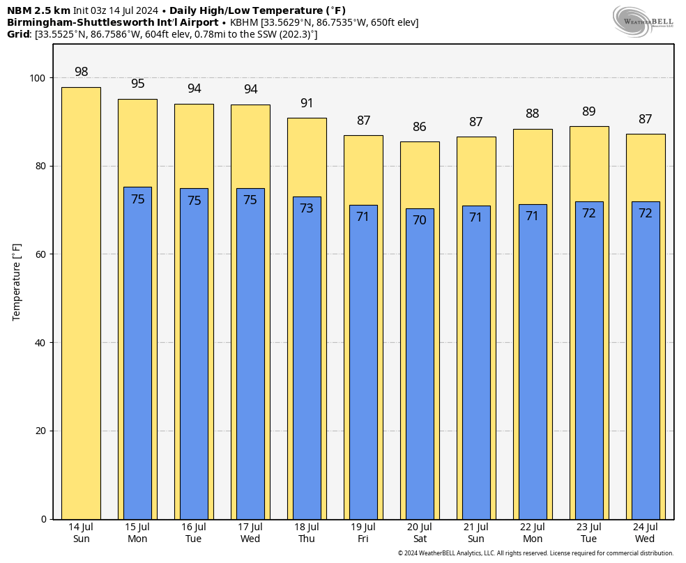
FOR YOUR SUNDAY: The ridge will remain in control, and the heat and humidity will continue. Highs today will range from 95-100F across North and Central Alabama. Morning dewpoints will be 70F or higher. They will mix out in the afternoon into the middle and upper 60s. This will put heat index values into the 99-103F range, just short of heat advisory criteria. Remember your heat safety tips: take frequent rest breaks in the shade or air conditioning; bring pets indoors or provide shade and plenty of water; avoid strenuous activity during the hottest part of the day; wear lightweight, light-colored, loose clothing; check on elderly or ill neighbors and family members; avoid alcohol and caffeine; watch for signs of heat illness; drink plenty of water, even if not thirsty; never leave kids or pets unattended in vehicles. Isolated showers/storms will form, but they will struggle to maintain themselves. They will die out around sunset. Lows tonight will be in the lower 70s.
START OF THE WORK WEEK: Monday and Tuesday will feature more of the same, with partly cloudy, hot, and humid conditions, with only isolated showers and storms. Highs will be in the middle and upper 90s on both days. Lows will be in the middle 70s.
RIDGE BEGINS TO BREAK DOWN: By Wednesday, the ridge will begin breaking down. We will watch for a cold front approaching from the north. Rain chances will edge up starting on Wednesday, and we could see fairly widespread storms by Thursday. The front should stall over Central Alabama by Friday, and a wave of low pressure could keep rain chances high on Friday and Friday night. We will be grateful for any rain that we can gather at the end of the week. Rainfall totals through next Saturday look like they will average 2-2.5 inches. Some lucky spots will get more. Temperatures on Wednesday will still be hot in the lower and middle 90s. Thursday and Friday will be cooler, with highs in the 80s with all the clouds and showers around.
WEEKEND OUTLOOK: The front washes out as we head into the weekend. Scattered showers and thunderstorms will develop in the heat and humidity. Temperatures will be cooler in the wake of the front.
VOODOO TERRITORY: It looks like the below normal temperatures will continue into the week two forecast period. Showers and thunderstorms will thin out through Monday and Tuesday as the upper trough deepens over the northeastern United States. Another front will take advantage of the weakness in the upper pattern. This front will be supported by a big anticyclone over the northeastern part of the country, so it may push into South Alabama. The last weekend of the month looks drier and trending warmer again.
BEACHCAST: We are deep in the doldrums of summer along the beautiful beaches of Alabama and Northwest Florida. High heat, extreme UV levels, hot water temperatures that are in the upper 80s. Widely scattered showers and storms will be the norm in the days ahead. Rain chances will ramp up by Thursday with the front approaching from the north. They will remain high on Friday and Saturday, diminishing after that. The good news is that the rip current risk will be low into midweek.
Click here to see the Beach Forecast Center page.
IN THE TROPICS: Dry air covers much of the tropical Atlantic right now, and that is contributing to this lull in activity that we are thankfully in right now. Global models indicate no tropical development in the 10-15 day period.
NATIONALLY: Heat is the story nationally, with numerous heat advisories, excessive heat watches, excessive heat warnings, and red flag warnings across the country.
DANCING WITH THE STATS: The NWS in Little Rock reported that they have had 44 tornadoes in Arkansas this year. 27 of them occurred in May, including 17 on the 26th. Three of those tornadoes were reported as EF3s. The remnants of Hurricane Beryl caused nine tornadoes on July 8th. This is the largest tornado outbreak in Arkansas in July.
WEATHERBRAINS: This week, the panel had a great time with Weather Channel storm chaser Charles Peek. It is a moving and powerful conversation. Don’t miss it! Check out the show at www.WeatherBrains.com. You can also subscribe on iTunes. You can watch the show live on our new YouTube channel for the show, and you can see the live show on the James Spann 24×7 weather channel on cable or directly over the air on the dot two feed.
ON THIS DATE IN 1911: Baguio, located on the island of Luzon in the Philippines, experienced a torrential downpour as a typhoon swept through the area. Within a span of 24 hours, an astonishing 45.99 inches of rain deluged the city, drenching it in a relentless cascade. But the rainfall did not cease there, for in a mere 63 hours, an astounding total of over 79 inches of rain descended upon Baguio. This remarkable event established a world record for 24-hour precipitation, a record that remained unbroken until the installation of rain gauges by the French on the volcanic mountain peaks of Reunion Island in the Indian Ocean. Follow my weather history tweets on Twitter. I am @wxhistorian at Twitter.com.
Category: Alabama's Weather, ALL POSTS, Weather Xtreme Videos
About the Author (Author Profile)
Bill Murray is the President of The Weather Factory. He is the site's official weather historian and a weekend forecaster. He also anchors the site's severe weather coverage. Bill Murray is the proud holder of National Weather Association Digital Seal #0001 @wxhistorianSubscribe
If you enjoyed this article, subscribe to receive more just like it.


