Thursday Morning Debby Update: Numerous Flash Flood Warnings in the Carolinas
Good morning! Tropical storm Debby made a second landfall during the wee hours of the morning near Bulls Bay, SC. Max sustained winds were 50 mph. Minimum central pressure at 995 mb.
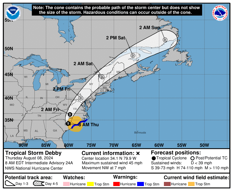
As of 7am CDT: Debby had max winds at 45 mph and was moving to the northwest. It is starting to pick up the pace at 7 mph. A continued acceleration is expected and Debby will be in the Mid-Atlantic and Northeast Friday and Atlantic Canada on Saturday. Debby will continue to weaken and should be a depression later today.
Numerous flash flooding warnings are in effect at this time across portions of the Carolinas. Considerable flooding from Winston-Salem to Raleigh-Durham to Fayetteville, Lumberton and Wilmington. Several rain bands continue to set up in this area. Some areas have picked up 2-4 inches of rain over the past 6 hours with a few more inches expected. Over the past 24 hours – some areas have seen over 6-8 inches of rain.
Scenes across Bladenboro, North Carolina last night during a Flash Flood Emergency. #Debby #NCwx @accuweather pic.twitter.com/MyO4uU3aqR
— Aaron Rigsby (@AaronRigsbyOSC) August 8, 2024
There is still a tornado threat with the band coming in across the southeast. There have been numerous warnings through the night and this morning, and reported damage.
(Likely) tornado damage to this stretch of homes on this road here outside of Raleigh, North Carolina from #Debby
Several roofs caved in, people searching for their belongings and checking to see if everyone is accounted for
(They’re not) pic.twitter.com/NroThDEh0g
— Marissa Parra NBC (@MarParNews) August 8, 2024
Damage at the Springfield middle school on Wiggins Mill road in Wilson county north of Lucama NC. Picture credit fighting crime news and who’s wanted Facebook page @NWSRaleigh @WRAL @wralweather #ncwx #debby pic.twitter.com/BiClAOMdJY
— Stephen (@Stephen122080) August 8, 2024
About the Author (Author Profile)
Owner of Tornado Talk. Radio broadcast meteorologist with The Storm Report. WeatherBrains Panelist. B.S. Meteorology from Penn State University.Subscribe
If you enjoyed this article, subscribe to receive more just like it.


