We Have Tropical Storm Ernesto
Tropical Storm Ernesto has now officially formed, with a center of circulation and deep convection gradually organizing in bands around the storm. The Air Force Hurricane Hunters confirmed this development, reporting a central pressure of 1009 mb and consistent flight-level winds of 40-45 knots. An SFMR reading also showed winds at 39 knots. Currently, there are two reconnaissance planes en route to continue monitoring Ernesto: one from NOAA and another from the Air Force.
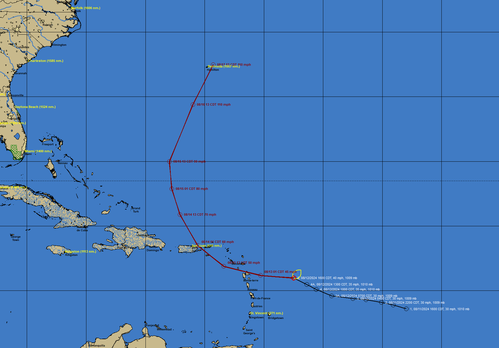
FAST FACTS AT 4 PM ON ERNESTO
———————————————-
LOCATION…16.0N 57.5W
ABOUT 295 MI…475 KM ESE OF ANTIGUA
ABOUT 590 MI…950 KM ESE OF SAN JUAN PUERTO RICO
MAXIMUM SUSTAINED WINDS…40 MPH…65 KM/H
PRESENT MOVEMENT…WNW OR 285 DEGREES AT 28 MPH…44 KM/H
MINIMUM CENTRAL PRESSURE…1009 MB…29.80 INCHES
Track and Intensity: Ernesto is expected to continue moving quickly to the west-northwest under the influence of a strong low- to mid-level ridge located to the north. This path will take the storm across the northern Leeward Islands tonight and near or over the Virgin Islands and Puerto Rico by Tuesday evening. A significant slowdown and a turn to the north are forecast as Ernesto reaches the western Atlantic, influenced by a deep-layer trough pushing off the U.S. east coast.
Gradual strengthening is anticipated over the next few days, particularly after the system moves out of the Caribbean and encounters more favorable conditions. Ernesto could reach hurricane strength later this week as it turns northward over the western Atlantic.
WARNINGS
——–
The current warnings in effect for Tropical Storm Ernesto include:
– Tropical Storm Warnings are in effect for St. Kitts, Nevis, Montserrat, Antigua, Barbuda, Anguilla, Guadeloupe, St. Martin, St. Barthelemy, Sint Maarten, the British Virgin Islands, the U.S. Virgin Islands, Puerto Rico, Vieques, and Culebra. These warnings indicate that tropical storm conditions are expected within these areas within the next 36 hours.
Residents in these areas should prepare for tropical storm conditions, including strong winds, heavy rainfall, potential flash flooding, and storm surge impacts.
FORECASTS FOR ANTILLES
———————-
St. Thomas: Expected to experience maximum sustained winds of 54 mph with gusts up to 65 mph, beginning around 6:30 PM CDT on August 13. Wind speeds will gradually decrease after peaking around 10:30 PM. Light rain and minor damage are anticipated.
San Juan, PR: Winds of 47 mph with gusts up to 57 mph are expected to begin around 11:30 PM on August 13, peaking around 1:00 AM on August 14. The area could see up to 10 inches of rain, particularly in the higher elevations, leading to potential flash flooding and mudslides.
Guadeloupe: Winds of 45 mph with gusts up to 54 mph are forecast to begin early on August 13, with the strongest winds expected around 6:30 AM. Minor damage is expected, with up to 4-6 inches of rain possible.
St. Martin: Maximum sustained winds of 44 mph with gusts up to 53 mph are forecast, starting around noon on August 13. The strongest winds are expected by late afternoon, with minor damage and localized flooding possible.
BERMUDA
——-
Bermuda is expected to experience a major impact from Tropical Storm Ernesto, with the most severe conditions forecasted for Saturday, August 17th. Winds could reach sustained speeds of 109 mph with gusts up to 132 mph, particularly from the northeast. These conditions are anticipated to begin Friday afternoon with tropical storm-force winds, intensifying to hurricane-force winds by early Saturday morning. The storm’s peak intensity is expected around 10 AM CDT, causing considerable structural damage, widespread power outages, and making several roads and access routes impassable due to large debris.
GENERAL IMPACTS
—————
Rainfall: Ernesto is expected to produce 4 to 6 inches of rain across the Leeward and Virgin Islands, with up to 10 inches possible in Puerto Rico. This heavy rainfall may result in considerable flash flooding and mudslides, particularly in mountainous areas.
Winds: Tropical storm conditions are expected in the warning areas for the Leeward Islands beginning late tonight, with these conditions spreading to the Virgin Islands and Puerto Rico by Tuesday evening.
Storm Surge: A storm surge of 1 to 3 feet above normal tide levels is expected along the eastern coast of Puerto Rico, the U.S. and British Virgin Islands, and the northern Leeward Islands. This surge will be accompanied by dangerous waves.
Surf: Swells generated by Ernesto will affect portions of the Leeward Islands starting late tonight, causing life-threatening surf and rip current conditions.
Sounding and Reconnaissance Information: The latest sounding data from extra balloon launches by the National Weather Service in San Juan has provided valuable insights into the atmospheric environment surrounding Ernesto. These special soundings, along with data from reconnaissance flights, confirm the expected northward turn of Ernesto after it crosses Puerto Rico.
FREQUENT UPDATES
—————-
We will have two to three updates on Ernesto for the remainder of its life, on top of our normal Spann and weekend videos and midday updates.
About the Author (Author Profile)
Bill Murray is the President of The Weather Factory. He is the site's official weather historian and a weekend forecaster. He also anchors the site's severe weather coverage. Bill Murray is the proud holder of National Weather Association Digital Seal #0001 @wxhistorianSubscribe
If you enjoyed this article, subscribe to receive more just like it.


