Generally Dry Pattern Continues; Seasonal Temperatures
QUIET SUMMER PATTERN: This will be another dry day for Alabama with highs in the low to mid 90s this afternoon. The weather won’t change much through mid-week with only isolated showers tomorrow and Thursday. We will mention a slightly higher coverage of scattered showers and storms on Friday with the approach of a surface front, but even then the chance of any one spot seeing a shower will be in the 20-25 percent range. Afternoon highs will stay in the 91-95 degree range for most communities.
The front will drop into South Alabama and dissipate over the weekend; any showers Saturday and Sunday should be few and far between, and mainly over the southern counties of the state. Otherwise expect a partly to mostly sunny sky both days with highs generally in the low 90s.
NEXT WEEK: Still no sign of any major, widespread rain event for the Deep South through the week. We could certainly see a few isolated showers or storms on a few days, but many places will stay dry. And, temperatures remain near average for mid-August with highs mostly between 90 and 94 degrees. See the video briefing for maps, graphics, and more details.

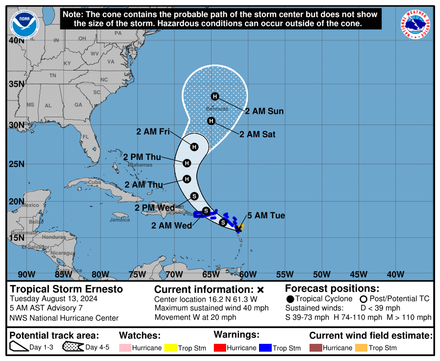
ERNESTO: Tropical Storm Ernesto early this morning has winds of 40 mph, and is centered about 350 miles east/southeast of San Juan, Puerto Rico. The system is moving to the west at 20 mph.
Ernesto will be near Puerto Rico late tonight; a tropical storm warning is in effect there. A sharp turn to the north is expected tomorrow in response to an upper trough to the west, keeping Ernesto well east of the U.S. However, it is forecast to be very close to Bermuda Saturday as a category two hurricane.
The rest of the Atlantic basin is very quiet.
ON THIS DATE IN 1987: A succession of thunderstorms produced rainfall that was unprecedented in 116 years of precipitation records at Chicago, Illinois during an 18 hour period from the evening of the 13th to the early afternoon of the 14th. The resulting flash flood was the worst ever to strike the Chicago metropolitan area, causing three deaths and water damage that amounted to 221 million dollars.
ON THIS DATE IN 2004: Hurricane Charley made landfall near the island of Cayo Costa, Florida as a 150 mph Category 4 hurricane. An hour later, the hurricane struck Punta Gorda as a 145 mph storm and then passed up through Port Charlotte and the Charlotte Harbor. However, the eye had shrunk before landfall, limiting the most powerful winds to an area within 7 miles of the center. Charley was initially expected to hit further north in Tampa, and caught many Floridians off-guard due to a sudden change in the storm’s track as it approached the state. Along its path, Charley caused 10 deaths and $16.9 billion in damage to insured residential property, making it the second costliest hurricane in United States history at the time.
Look for the next video briefing here by 3:00 this afternoon… enjoy the day!
Category: Alabama's Weather, ALL POSTS, Weather Xtreme Videos
About the Author (Author Profile)
James Spann is one of the most recognized and trusted television meteorologists in the industry. He holds the AMS CCM designation and television seals from the AMS and NWA. He is a past winner of the Broadcast Meteorologist of the Year from both professional organizations.Subscribe
If you enjoyed this article, subscribe to receive more just like it.


