Ernesto Strengthens as it Approaches the Virgin Islands: Latest Updates and Forecasts
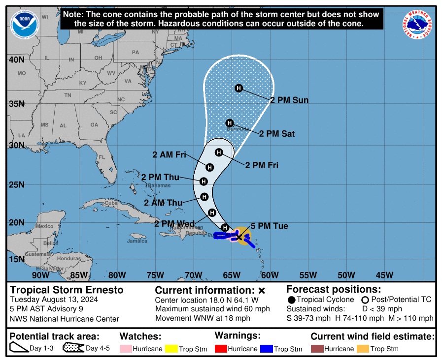
Tropical Storm Ernesto continues to gradually increase in organization as it moves west-northwest at 18 mph toward the Virgin Islands and Puerto Rico. As of 5:00 PM AST on August 13, 2024, the storm’s center is located near 18.0N, 64.1W, approximately 65 miles east-southeast of St. Thomas and 135 miles east-southeast of San Juan, Puerto Rico. Maximum sustained winds are at 60 mph with higher gusts, and the minimum central pressure has dropped to 1001 mb.
Recent observations and aircraft reconnaissance indicate that Ernesto is strengthening as it approaches the Virgin Islands. The Air Force Reserve Hurricane Hunter aircraft measured peak 850-mb flight-level winds of 57 kt and SFMR winds of 45-50 kt. Satellite imagery shows Ernesto becoming better organized, with an inner core starting to develop. This suggests that Ernesto may reach hurricane strength tonight as it moves near or over the Virgin Islands.
Ernesto is expected to continue its west-northwestward motion tonight, with a turn toward the northwest and a decrease in forward speed. The storm is forecast to pass near or over the Virgin Islands this evening, then move northeast and north of Puerto Rico tonight and Wednesday. Ernesto will then move over the western Atlantic, with the center approaching Bermuda by Friday. The storm is expected to strengthen into a hurricane tonight and continue intensifying, possibly reaching just below major hurricane strength within 60-72 hours.
A Hurricane Watch is in effect for the U.S. Virgin Islands, British Virgin Islands, Vieques, and Culebra. A Tropical Storm Warning is in effect for St. Kitts, Nevis, Anguilla, St. Martin, St. Barthelemy, Sint Maarten, Saba, Sint Eustatius, British Virgin Islands, U.S. Virgin Islands, Puerto Rico, Vieques, and Culebra.
Forecast for San Juan, Puerto Rico (TJSJ):
San Juan is expected to receive a minor impact from Tropical Storm Ernesto. Strong wind gusts of up to 55 mph are possible, with maximum sustained winds of 46 mph expected around 1 AM CDT on August 14. Westerly tropical storm force winds should start affecting the area by midnight CDT, with winds decreasing below tropical storm force by 6 AM CDT. No significant wind damage is expected, but residents should prepare for gusty conditions and potential power outages.
Forecast for the Virgin Islands:
The Virgin Islands are expected to experience deteriorating weather conditions this evening into Wednesday morning, with gusts up to 70-80 mph in the British Virgin Islands and 55-75 mph in the U.S. Virgin Islands. Heavy rainfall of 6-8 inches is expected, with isolated areas receiving up to 10 inches, leading to a significant threat of flooding and mudslides.
A storm surge of 1-3 feet is anticipated for the U.S. Virgin Islands, as well as the British Virgin Islands, accompanied by large and destructive waves. Dangerous swells and rip currents are expected to impact the Leeward Islands, Virgin Islands, and Puerto Rico, reaching the Bahamas by Thursday.
Forecast for Bermuda, UK:
Bermuda is expected to receive a significant impact from Tropical Storm Ernesto. Dangerous wind gusts of up to 90 mph are possible, with maximum sustained winds of 75 mph expected around 11 AM CDT on August 17. Easterly tropical storm force winds should begin affecting the area by Friday evening, with hurricane force winds arriving by Saturday morning. The storm could cause considerable roof damage, power outages, and impassable roads due to fallen debris.
There is still uncertainty regarding Ernesto’s potential impact on Atlantic Canada. Some models suggest a direct hit on northeastern Nova Scotia, Cape Breton Island, and Newfoundland, while others indicate a miss. Residents in these areas should closely monitor the storm’s progress.
Ernesto is a strengthening tropical storm with the potential to become a hurricane as it passes near or over the Virgin Islands tonight and then moves toward Bermuda by the weekend. Residents in affected areas should complete preparations, heed local warnings, and stay informed of updates as the storm progresses.
About the Author (Author Profile)
Bill Murray is the President of The Weather Factory. He is the site's official weather historian and a weekend forecaster. He also anchors the site's severe weather coverage. Bill Murray is the proud holder of National Weather Association Digital Seal #0001 @wxhistorianSubscribe
If you enjoyed this article, subscribe to receive more just like it.


