Hurricane Ernesto Continues to Impact Bermuda While Slowly Moving Away
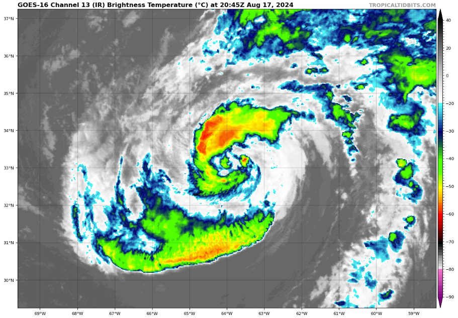
As of 5:00 PM AST on Saturday, Hurricane Ernesto is beginning to inch away from Bermuda, but the island is still experiencing significant tropical storm conditions. The center of Ernesto is located approximately 85 miles northeast of Bermuda, moving slowly north-northeastward at 6 mph. Despite this slow movement, Ernesto’s outer rainbands continue to lash Bermuda with strong winds, heavy rain, and coastal flooding. Wind speeds have slightly decreased, with maximum sustained winds now at 75 mph, but hurricane-force gusts remain possible within the strongest rainbands.
Over the next 12 hours, Ernesto is expected to maintain its slow movement before accelerating to the north-northeast on Sunday as it interacts with an approaching trough. The hurricane is forecast to remain near or at its current strength as it moves over the warm waters of the Atlantic. By late Monday or Monday night, Ernesto is expected to pass near southeastern Newfoundland, potentially bringing strong winds, heavy rainfall, and rough seas to the region. The storm is projected to become post-tropical by Monday night or Tuesday morning as it moves over colder waters and encounters higher wind shear.
Ernesto’s impacts on Bermuda are not yet over. The island can expect continued strong winds, with tropical storm conditions persisting through tonight. Additional rainfall of 1 to 2 inches is anticipated, bringing the storm total to 7 to 9 inches. This could lead to life-threatening flash flooding, particularly in low-lying areas. Coastal flooding and large, destructive waves remain a concern as onshore winds continue to batter the island’s coastlines.
Beyond Bermuda, Ernesto is generating swells that are affecting parts of the Bahamas, the U.S. East Coast, and Atlantic Canada. These swells are creating dangerous surf and rip current conditions, which are expected to persist into the early part of next week. Beachgoers in these areas should exercise caution and heed any warnings from local authorities.
Here are some notes from the surface observations made at LF Wade International during Ernesto:
– Wind Speeds and Gusts: The most significant weather feature was the intense wind speeds and gusts recorded at the airport. Winds reached sustained speeds of up to 58 mph, with gusts as high as 84 mph at 1:55 am on August 17th as the eye of Hurricane Ernesto approached. Winds shifted from easterly to westerly as the hurricane moved over the island, indicating the passage of the eye.
– Pressure Drops: The lowest recorded sea level pressure was 969.98 mb at 8:07 am on August 17th. This sharp drop in pressure, recorded during the height of the storm, is indicative of the close passage of the hurricane’s eye over Bermuda.
– Visibility and Rain: Visibility was severely reduced due to heavy rain and mist, dropping to as low as 0.50 miles during the height of the storm. Heavy rain accompanied by mist was recorded for several hours, especially from 2:55 am to 6:55 am on August 17th.
– Temperature and Humidity: Despite the storm, temperatures remained steady around 77-79°F, with relative humidity consistently at 100%. This high humidity level, combined with the heavy rainfall, contributed to the misty conditions observed throughout the storm.
– Cloud Cover: The sky was consistently overcast with low clouds during the storm, with broken clouds at around 500-800 feet and overcast layers as low as 400 feet, further contributing to the poor visibility.
About the Author (Author Profile)
Bill Murray is the President of The Weather Factory. He is the site's official weather historian and a weekend forecaster. He also anchors the site's severe weather coverage. Bill Murray is the proud holder of National Weather Association Digital Seal #0001 @wxhistorianSubscribe
If you enjoyed this article, subscribe to receive more just like it.


